Kaiparowits Plateau
Coordinates: 37°37′19″N 111°39′54″W / 37.622°N 111.665°W

The Kaiparowits Plateau is a large, elevated landform located in southern Utah, in the southwestern United States. Along with the Grand Staircase and the Canyons of the Escalante, it makes up a significant portion of the Grand Staircase-Escalante National Monument. Its extension to the southeast, Fiftymile Mountain, runs nearly to the Colorado River and Lake Powell, and is a prominent part of the northern skyline from the Glen Canyon National Recreation Area.
Geography
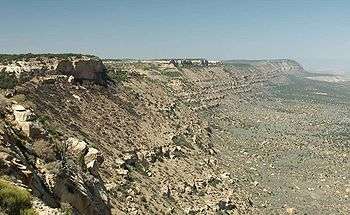
Roughly triangular in shape, the Kaiparowits Plateau extends for over 50 miles (80 km) from near the town of Escalante in Garfield County, to the south and southwest through Kane County and nearly to the border with Arizona. At its southeastern end the plateau rises from Lake Powell nearly 4000 feet (1200 m) to an elevation of 7584 feet (2311 m). The northeastern edge of the plateau is defined by the Straight Cliffs, below which are the broad sandstone flats of the Escalante River. The western edge of the plateau is at the Paria River, Cottonwood Canyon, and the Cockscomb.
The southern end of the plateau is deeply dissected by tributaries of the Colorado River, including Rock, Last Chance, Warm, Wahweap, and Coyote Creeks. These canyons are now major side channels of Lake Powell. An extension of the plateau's high terrain is known as Smoky Mountain, location of one of the few roads on the plateau. The northwestern end of the plateau is less well defined, essentially merging with the Aquarius Plateau. Canaan Peak, just south of Highway 12 and the town of Escalante, rises to 9233 feet (2814 m). Overall, the plateau covers an area of approximately 1650 square miles (4225 km²),[1] much of it covered by pinyon-juniper woodland.
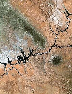
This topography is well illustrated in a synthetic aerial image (here, 450 kB), which looks northwest from a point near Navajo Mountain. The Kaiparowits Plateau is the darker area to the left, while the Escalante River Basin is the lighter area to the right. The Colorado River (as Lake Powell) runs across the bottom of the image, and at the upper right is the Aquarius Plateau and Boulder Mountain.
Geology
During the later part of the Cretaceous geologic period, the area that is now the Kaiparowits Plateau was located near the western shore of the Western Interior Seaway.[1] The interior of the plateau was an area of peat swamps, while what is now the Straight Cliffs were at the shoreline. Further to the west was an area known as the Sevier Highlands. Erosion from the Highlands deposited approximately 1500 feet (500 m) of what is now known as the Straight Cliffs Formation, a layer of sandstone that makes up the base of the plateau. Remnants of the peat are now seen as beds of coal within this layer. Later deposits during the Cretaceous period formed higher sandstone layers, known as the Wahweap and Kaiparowits Formations. Further deposition during later epochs formed layers that are now seen at the surface of the plateau, including the limestone layers of the Wasatch Formation.
Fossils
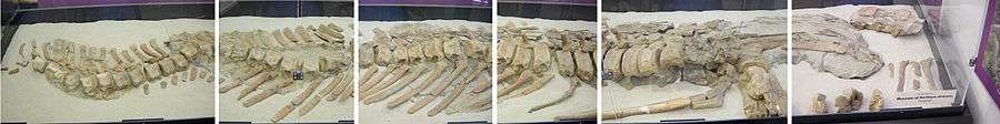
The sandstone layers of the Kaiparowits Plateau have become a unique source of fossilized remains of the Late Cretaceous Period, vital to understanding the evolution of dinosaur and early mammalian species.[2] These layers represent not only an unbroken sequence of the period between 70 and 82 million years ago, but have also preserved fine details of the bones, teeth, egg shells, and even the tracks of the animals that lived then. The skull of a ceratopsid, a horned dinosaur, was unearthed from the Wahweap Formation in 1998.[3] A species of Struthiomimus, a toothless (yet carnivorous) dinosaur, was identified in the Kaiparowits Formation. As recently as 2007, the characterization of an unusual species of Gryposaurus, a duck-billed dinosaur, was announced.[4] Fossils of the giant crocodilian Deinosuchus have also been found.[5]
Coal mining
Early settlers of the region mined certain parts of the plateau for coal in the 1870s and 1880s. The Spencer mine opened in 1913, reportedly to fuel gold mining activities along the Paria River.[6]:67–71
In 1965, the Southern California Edison Company proposed the construction of a 3000 megawatt coal-fired generation plant within the Kaiparowits Plateau.[7] [8] This plant was intended to be fed by large coal deposits in the plateau, which may have yielded up to 4 billion tons of fuel. The electricity produced would have gone to the growing populations near Los Angeles, San Diego, and Phoenix. Initially hailed as an economic boon to this isolated area of southern Utah, the proposal met with growing opposition from federal regulatory agencies and from environmental groups, who had only recently experienced the scenic canyons of the Colorado River and its tributaries being inundated by Lake Powell, behind the Glen Canyon Dam. After ten years of dispute and facing rising construction costs, the proposal was abandoned in 1975.
Sources and further reading
- 1 2 Geology and Coal Resources of the Kaiparowits Plateau
- ↑ Page (Arizona) Paleontology Science Center
- ↑ Fossil Discoveries in the Grand Staircase-Escalante National Monument (PDF)
- ↑ Newspaper account of the discovery of Gryposaurus monumentensis
- ↑ "FIRST REPORT OF THE HYPER-GIANT CRETACEOUS CROCODYLIAN DEINOSUCHUS FROM UTAH". gsa.confex.com. Retrieved 2016-03-27.
- ↑ Doelling, H. H.; Graham, R. L. (1972). Southwestern Utah Coal Fields: Alton, Kaiparowits Plateau and Kolob-Harmony. Utah Geological and Mineralogical Survey.
- ↑ Final Environmental Impact Statement, Proposed Kaiparowits Project. Prepared by US Bureau of Land Management. 1976. OCLC 2063464.
- ↑ "Kaiparowits". Utah History Encyclopedia.
| Wikimedia Commons has media related to Kaiparowits Plateau. |
External links
- TopoQuest topographic map
- Other synthetic aerial images for Kane County, Utah
- Synthetic aerial images for Garfield County, Utah