Utah State Route 12
| ||||
|---|---|---|---|---|
| A Journey Through Time Scenic Byway | ||||
 | ||||
| Route information | ||||
| Defined by Utah Code §72-4-107 | ||||
| Maintained by UDOT | ||||
| Length: | 122.863 mi[1] (197.729 km) | |||
| Existed: | 1914 as a state highway; 1920s as SR-12 – present | |||
| Tourist routes: |
| |||
| Major junctions | ||||
| West end: |
| |||
|
Hole in the Rock Rd. near Escalante | ||||
| East end: |
| |||
| Highway system | ||||
| ||||

State Route 12 or Scenic Byway 12 (SR-12), also known as "Highway 12 — A Journey Through Time Scenic Byway", is a state highway designated an All-American Road located in Garfield County and Wayne County, Utah, United States.
Route description
Proceeding west to east for 122 miles (nearly 200 km), the highway starts south of Panguitch at an intersection with US-89, crosses part of Dixie National Forest and Bryce Canyon National Park, continues through the small towns of Tropic, Cannonville, and Henrieville. It crosses various parts of Grand Staircase-Escalante National Monument (GS-ENM), continues northeast through Escalante and over the Escalante River, then north through more of GS-ENM, Boulder, the Aquarius Plateau, Grover, ending in Torrey at an intersection with SR-24, five miles (8 km) west of Capitol Reef National Park. The 30-mile (48 km) long portion of the highway that ascends and descends Boulder Mountain on the Aquarius Plateau is known as Boulder Mountain Highway.
Traffic volume
The Average Daily Traffic (AADT) on SR-12 is at its greatest at its western junction with US-89, where the count for 2005 was 2,430. At its other end, at the junction with SR-24, the traffic bottoms out at 435.[2]
History
The road from Bryce Canyon Junction to Tropic was added to the state highway system in 1914, and in 1923 a branch from Tropic Junction to Bryce Canyon was built as a forest road.[3] The State Road Commission numbered the route to Bryce Canyon SR-12 in the 1920s,[4] and in 1927 the state legislature assigned it to both branches, to Bryce Canyon and Tropic,[5] but split off the branch to Tropic as State Route 54 in 1931. That same year, a new State Route 120 was created, continuing the road from Tropic to Henrieville,[6] and in 1935 it became part of SR-54.[7] Another road was also added to the state highway system in 1914, connecting SR-22 at Widtsoe with Escalante,[8] and it was numbered State Route 23 in 1927.[9] An extension took SR-23 northeast to Boulder in 1941,[10] and in 1947 SR-54 absorbed SR-23, with the Widtsoe-Escalante road dropped in favor of Henrieville-Escalante.[11] State Route 117, running southeast from SR-24 near Teasdale to Grover, became a state highway in 1931,[12] and was extended south to Boulder in 1957, becoming part of SR-54 in 1966.[13] In 1969, SR-54 became part of SR-12, but most of former SR-117 was dropped, leaving SR-12 to stretch from Bryce Canyon Junction to the north limit of Boulder (at the Dixie National Forest boundary), with a short spur to Bryce Canyon. This spur became a new SR-63 in 1975, and in 1985 the route was extended back north from Boulder to SR-24, using a different route than old SR-117 north of Grover.[3]
Major intersections
| County | Location | mi[1] | km | Destinations | Notes |
|---|---|---|---|---|---|
| Garfield | Bryce Canyon Junction | 0.000 | 0.000 | ||
| | 10.713 | 17.241 | East Fork of the Sevier Scenic Backway | ||
| Tropic Junction | 13.598 | 21.884 | Former SR-22 | ||
| Cannonville | 25.657 | 41.291 | Cottonwood Canyon Scenic Backway – Kodachrome Basin State Park | ||
| | 54.643 | 87.939 | Main Canyon Road | Former SR-23 | |
| Escalante | 58.968 | 94.900 | Smokey Mountain Scenic Backway | ||
| 59.830 | 96.287 | Posey Lake Scenic Backway | |||
| | 64.392 | 103.629 | Hole-in-the-Rock Scenic Backway | ||
| | 83.270 | 134.010 | Hell's Backbone Road | ||
| Boulder | 86.352 | 138.970 | Burr Trail Scenic Backway | ||
| Wayne | | 118.179 | 190.191 | Teasdale | Former SR-117 |
| | 122.863 | 197.729 | |||
| 1.000 mi = 1.609 km; 1.000 km = 0.621 mi | |||||
See also
Gallery
SR-12 goes north up the canyon in the upper left of the photo after crossing the Escalante River. 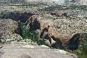
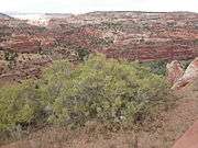
The canyons after the Escalante River. 
Moonrise over SR-12 in Grand Staircase-Escalante National Monument 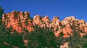
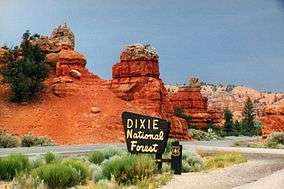
Red Canyon, in Utah's Dixie National Forest, is near the western end of Route 12. 
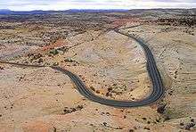
An overlook from the eastern portion of Highway 12. 
Calf Creek Canyon runs near Route 12. 
The bridge on Hell's Backbone Road. 
Red Canyon Scenic Drive. 
State Route 12 in Utah - Panorama looking north and east from Head of the Rocks Overlook.
References
- 1 2 Utah Department of Transportation, Highway Reference Information: SR-12, updated 2008-05-01. Retrieved July 2008.
- ↑ UDOT Traffic Counts, page 6
- 1 2 Utah Department of Transportation, Highway Resolutions: "Route 12". (9.72 MB), updated September 2007, accessed May 2008
- ↑ State Road Commission, Utah State Trunk Lines, 1923
- ↑ Utah State Legislature (1927). Chapter 21: Designation of State Roads. Session Laws of Utah.
12. From Hillsdale, about 7 miles south of Panguitch, southeasterly via Tropic Junction; to Bryce Canyon; also from Tropic Junction to Tropic.
- ↑ Utah State Legislature (1931). Chapter 55: Designation of State Roads. Session Laws of Utah.
(54) From Tropic junction on route 12 to Tropic." "(120) From Tropic southerly via Cannonville to Henrieville.
- ↑ Utah State Legislature (1935). Chapter 37: Designation of State Roads. Session Laws of Utah.
- ↑ Utah Department of Transportation, State Route History. Retrieved July 2007.
- ↑ Utah State Legislature (1927). Chapter 21: Designation of State Roads. Session Laws of Utah.
23. From Widtsoe easterly to Escalante.
- ↑ Utah State Legislature (1941). Chapter 34. Session Laws of Utah.
- ↑ Utah State Legislature (1947). Chapter 49. Session Laws of Utah.
Route 54. From Tropic Junction on route 12 via Tropic, Cannonville, Henrieville, and Escalante to Boulder.
- ↑ Utah State Legislature (1931). Chapter 55: Designation of State Roads. Session Laws of Utah.
(117) From junction with route 24 east of Bicknell, southerly via Teasdale to Grover.
- ↑ Utah Department of Transportation, Highway Resolutions: "Route 117". (1.56 MB), updated November 2007, accessed May 2008
External links
- Map and more from the DOT's American Byways website
- State of Utah's website for the highway
- Historic American Engineering Record (HAER) No. UT-83, "Red Canyon Tunnel, Through Rock Fin on State Highway 12, 5 miles east of U.S. 89, Panguitch, Garfield County, UT", 3 photos, 1 color transparency, 2 photo caption pages
- HAER No. UT-80, "Escalante River Bridge, Spanning Escalante River at State Route 12, 9.5 miles East of Escalante, Escalante, Garfield County, UT", 11 photos, 16 data pages, 1 photo caption page
| Wikimedia Commons has media related to Utah State Route 12. |