Kallang River

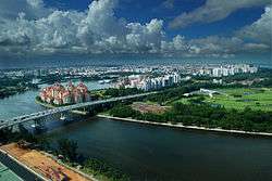
The Kallang River (Chinese: 加冷河, Malay: Sungei Kallang) flows for 10 kilometres from the Lower Peirce Reservoir to the coast at Nicoll Highway, making it the longest river in Singapore. The river mouth was traditionally at Kallang Basin, although extensive land reclamation around the area meant the river only flows into the open sea via the Marina Channel between Marina Centre and Marina East.
History
In pre-colonial times, the original inhabitants of Singapore, the aboriginal biduanda orang kallang, lived in the swamps at the mouth of the Kallang River, and fished from their boats, seldom venturing out into the open sea. At the time of Sir Stamford Raffles landing in Singapore in 1819, half of the population of 1,000 were orang kallang.
Kallang River was also the place, where in the early days the Bugis traders from Sulawesi (Celebes) unloaded their cargoes of spices and tortoise shells, gold dust and slaves from their palari or their leteh-leteh. These sailing boats were a common sight off the sea front even up to the 1960s.
Today, this long, winding river has little or no industry except for a short distance, although a new industrial estate at Kallang Basin, near Kallang Bahru, has been built.
Redevelopment
Kallang River is now part of the water catchment area for the Marina Reservoir. A dam, the Marina Barrage, was built at the mouth of the Marina Channel at Marina South. With the completion of the Marina Barrage in 2008, the entire region comprising the basins of the Singapore River, Rochor River, Geylang River and Kallang River has transformed into a water catchment area.
In April 2006, the Singapore government announced plans to give a 200-metre stretch of the Kallang River at Kolam Ayer a S$2.5 million facelift.
The "demonstration project" by the National Parks Board (NParks) and the Public Utilities Board (PUB) is part of the Active, Beautiful and Clean Waters Programme to transform rivers and reservoirs into vibrant community hubs, and to get Singaporeans to cherish and take care of their waterways. NParks and the PUB reviewed some of the world's best rivers such as the Charles River in the United States and the Cheonggye Stream in Seoul to draw inspiration and learn best practices.
By August 2007, the Kolam Ayer stretch of the river was transformed to include more greenery, floating decks, pathways and boardwalks for recreational activities. A water wheel was introduced as the centrepiece of the project. The water level was kept at a constant level — 3 metres deep — making activities such as kayaking and dragon boating possible.
Kallang River @ Bishan-Ang Mo Kio Park
The upstream of the Kallang River is located at Bishan-Ang Mo Kio Park. Officially opened on 17 March 2012 by Prime Minister Lee Hsien Loong, the meandering river's capacity is now 40% more than when it was a canal. The river helps to slow the flow of rainwater so that downstream waterways have more time to drain. Bio-engineering techniques such as soil bioengineering and intensive hydraulic calculations were applied to create this. Besides slowing down rainwater, it now also offers residents a new recreational experience – soft planted river banks encourage people to get close to the water.
References
| Wikimedia Commons has media related to Kallang River. |
- Norman Edwards, Peter Keys (1996), Singapore - A Guide to Buildings, Streets, Places, Times Books International, ISBN 9971-65-231-5
- Today, Making a splash with $2.5m, 17 April 2006,
Coordinates: 1°18′N 103°52′E / 1.300°N 103.867°E