Kamijima, Ehime
| Kamijima 上島町 | ||
|---|---|---|
| Town | ||
| ||
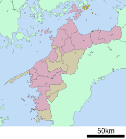 Location of Kamijima in Ehime Prefecture | ||
 Kamijima Location in Japan | ||
| Coordinates: 34°15′N 133°12′E / 34.250°N 133.200°ECoordinates: 34°15′N 133°12′E / 34.250°N 133.200°E | ||
| Country | Japan | |
| Region | Shikoku | |
| Prefecture | Ehime Prefecture | |
| District | Ochi | |
| Area | ||
| • Total | 30.38 km2 (11.73 sq mi) | |
| Population (March 31, 2006) | ||
| • Total | 8,116 | |
| • Density | 267.15/km2 (691.9/sq mi) | |
| Symbols | ||
| • Tree | Quercus phillyraeoides (姥目樫 Ubamegashi) | |
| • Flower | Sakura (桜) | |
| Time zone | Japan Standard Time (UTC+9) | |
| City hall address |
210 Shimoyuge, Yuge, Kamijima-chō, Ochi-gun, Ehime-ken 794-2592 | |
| Website |
www | |

Kamijima (上島町 Kamijima-chō) is a town located in Ochi District, Ehime Prefecture, Japan.
On October 1, 2004 the town was formed from the merger of the following towns and villages: Ikina, Iwagi, Uoshima, and Yuge. The name Kamijima literally means "upper island"; the town consists of a number of islands in the Seto Inland Sea.
As of March 31, 2006, the town has an estimated population of 8,116 and a density of 267.15 persons per km². The total area is 30.38 km².
External links
 Media related to Kamijima, Ehime at Wikimedia Commons
- Kamijima official website (Japanese)
| Core city | ||
|---|---|---|
| Cities | ||
| Iyo District | ||
| Kitauwa District | ||
| Nishiuwa District | ||
| Kamiukena District | ||
| Minamiuwa District | ||
| Ochi District | ||
| Kita District | ||
This article is issued from Wikipedia - version of the 11/7/2015. The text is available under the Creative Commons Attribution/Share Alike but additional terms may apply for the media files.