Kapuskasing Airport
| Kapuskasing Airport | |||||||||||||||
|---|---|---|---|---|---|---|---|---|---|---|---|---|---|---|---|
 | |||||||||||||||
|
IATA: YYU – ICAO: CYYU – WMO: 71831 | |||||||||||||||
| Summary | |||||||||||||||
| Airport type | Public | ||||||||||||||
| Operator | Corporation of the Town of Kapuskasing | ||||||||||||||
| Location | Kapuskasing, Ontario | ||||||||||||||
| Time zone | EST (UTC−05:00) | ||||||||||||||
| • Summer (DST) | EDT (UTC−04:00) | ||||||||||||||
| Elevation AMSL | 743 ft / 226 m | ||||||||||||||
| Coordinates | 49°24′42″N 082°28′06″W / 49.41167°N 82.46833°WCoordinates: 49°24′42″N 082°28′06″W / 49.41167°N 82.46833°W | ||||||||||||||
| Map | |||||||||||||||
 CYYU Location in Ontario | |||||||||||||||
| Runways | |||||||||||||||
| |||||||||||||||
| Statistics (2010) | |||||||||||||||
| |||||||||||||||
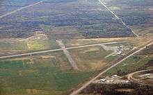
Aerial view of Kapuskasing Airport
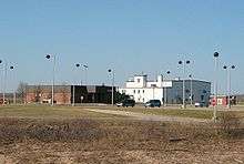
Kapuskasing Airport, (IATA: YYU, ICAO: CYYU), is located 2 nautical miles (3.7 km; 2.3 mi) west of the town of Kapuskasing in northern Ontario, Canada. The airport handles scheduled passenger service through Bearskin Airlines, which flies to Timmins and points beyond and serves as an Air Canada connector. It is an Airport of Entry, providing customs services for general aviation flights arriving directly from the United States.
General Motors uses the airport's runways for cold-weather testing of ground vehicles. It is also used for emergency medical flights.
Airlines and destinations
| Airlines | Destinations |
|---|---|
| Bearskin Airlines | North Bay, Sudbury, Thunder Bay, Timmins |
References
- ↑ Canada Flight Supplement. Effective 0901Z 15 September 2016 to 0901Z 10 November 2016
- ↑ Synoptic/Metstat Station Information
- ↑ Total aircraft movements by class of operation
External links
- Past three hours METARs, SPECI and current TAFs for Kapuskasing Airport from Nav Canada as available.
| By name | |
|---|---|
| By location indicator | |
| By province/territory | |
| By region | |
| National Airports System | |
| Related | |
| |
This article is issued from Wikipedia - version of the 12/4/2016. The text is available under the Creative Commons Attribution/Share Alike but additional terms may apply for the media files.