Karaburun
| Karaburun | |
|---|---|
| Town | |
|
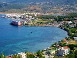
General view of Karaburun town center along Bodrum Cove | |
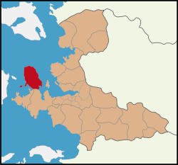 Location of Karaburun within İzmir Province, Turkey. | |
 Karaburun Location of Karaburun within İzmir Province, Turkey. | |
| Coordinates: 38°38′N 26°31′E / 38.633°N 26.517°ECoordinates: 38°38′N 26°31′E / 38.633°N 26.517°E | |
| Country |
|
| Region | Aegean |
| Province | İzmir |
| Government | |
| • Mayor | Ahmet Cakir(CHP) |
| Area[1] | |
| • District | 484.33 km2 (187.00 sq mi) |
| Elevation | 0-50 m (−160 ft) |
| Population (2012)[2] | |
| • Urban | 2,722 |
| • District | 8,799 |
| • District density | 18/km2 (47/sq mi) |
| Time zone | EET (UTC+2) |
| • Summer (DST) | EEST (UTC+3) |
| Postal code | 35x xx |
| Area code(s) | 0232 |
| Licence plate | 35 |
| Website | http://www.karaburun.bel.tr/ |
Karaburun is a district and the center town of the same district in Turkey's İzmir Province. The district area roughly corresponds to the peninsula of the same name (Karaburun Peninsula) which spears north of the tourism resorts of neighboring Çeşme and its dependencies and west of the city of İzmir. In fact, the district area is one of the westernmost points of Anatolia. Karaburun town is situated close to the northern tip of the peninsula and checks the entry of the Gulf of İzmir with the town of Foça, another important tourism resort, across the waters. The district's administrative zone is bordered by the districts of Çeşme and Urla in its south and faces the Greek island of Chios to its west.
Karaburun region is comparatively much less visited than Çeşme located in its south, its rate of urbanization at 20 per cent is the lowest across İzmir Province, although it provides an anticlimax to its southern neighbor and the associated attractions especially for those who want to escape the trails of mass tourism. The coasts of the peninsula have beautiful bays and pebble or sand beaches as yet often undiscovered by outsiders, although there is one German vacation village slightly to the north of the district center. Taken as a whole, in contrast with Çeşme, agriculture, fishing and livestock breeding, instead of tourism, remain the principal activities on which the district's economy is based. Karaburun's flora and fauna present particularities distinguishing it from the Anatolian mainland. Karaburun's name echoes in Turkey a very high variety of flower breeds present across its area, and especially narcissus and hyacinth.

Main features
The distance between Karaburun and İzmir center by way of land is 100 km (approximately 60 miles) and there are regular bus services and a three-lane modern highway until the toll near Çeşme. The rest of the road is narrow and curvy in some places and it may take up to two hours to reach Karaburun from İzmir. The country road is traced northwards along the eastern coast of the peninsula to reach Mordoğan first, which is, aside from Karaburun, the district's only other depending township with own municipality. After Karaburun, the same road continues towards the tip of the peninsula from where it heads west to reach the village of Küçükbahçe.
History
The oldest name known for the region was Mimas, in reference to the son of Gaia who was one of the Giants slain by Hephaistos during the war between Gods and Giants in Greek mythology. Homer mentions the "windy Mimas" mountain (present-day Bozdağ) in his Odyssey. The Mimas mountain is also associated with Iris, Leto and Narcissus. In Ionian through to Byzantine times, the region also carried the names Stelar or Stylarius, Caleberno by the Genoese and Ahırlı during the Ottoman era. There are different possibilities for the name Karaburun. One that is mentioned in the municipality web site is that it would be a modified form of Caleberno. Another possibility may have to do with the very translation of the Turkish name, which means "black cape", a fitting description especially for sailors who approach Karaburun Peninsula from open sea. The region is rich in history although its only sizeable urban center from ancient Greek, Byzantine through to Ottoman times was in Erythrai. Today the village of Ildırı stands in the ancient town's location and the village depends Çeşme. Traces of smaller settlements can also be traced back to the Bronze Age.
Karaburun is the most recently constituted district of İzmir, although the town of Karaburun was made into a municipality already in 1902.
Economy
Agriculture, fishing and livestock breeding remain the principal activities on which Karaburun's economy is based. The average yearly income level per inhabitant for the district was calculated at 3,673 US Dollars in 2007. Karaburun's trade relations with the outside world abroad remain modest, with total exports recorded as 26,319 US Dollars realized in 2007, mostly flowers, with also some exports of olive and olive oil and artichokes. Underground reserves include marble quarries, deposits of basalt, slate for constructions and clay for ceramics. Mercury was also mined in the past. The district's total number of companies stood at 525 the same year. There was only one bank operating through one branch in Karaburun in 2007.
| Villages | Distance to Karaburun (km) | Population |
| Ambarseki | 4 | 252 |
| Bozköy | 7 | 176 |
| Eğlenhoca | 12 | 342 |
| Hasseki | 12 | 91 |
| İnecik | 13 | 560 |
| Küçükbahçe | 33 | 773 |
| Kösedere | 11 | 619 |
| Parlak | 22 | 184 |
| Saip | 3 | 220 |
| Salman | 24 | 162 |
| Sarpıncık | 15 | 178 |
| Tepeboz | 8 | 31000 |
| Yayla | 13 | 127 |
The total number of residences in Karaburun district was counted as 8,912, an important part constituted by secondary residences owned by seasonal inhabitants. The total accommodation capacity of the district is 982 beds, in which the depending municipality of Mordoğan has a sizable share. The level of literacy in Karaburun nears hundred per cent, and the district is advantaged by the rather comfortable number of students, 12 in 2007, per teacher. There was one doctor for 1,447 patients in Karaburun in 2007.
Other information
Nearer to Karaburun is the abandoned village of Sazak whose inhabitants were subject to the 1923 Population exchange between Greece and Turkey in the frame of the Treaty of Lausanne. Sazak today is a ghost town rarely visited by tourists from Karaburun.
The whole district is very quiet during winter when the population of Karaburun center falls back to the usual 2500, with the owners of summer houses gone. Nevertheless, its spectacular gorges and heights makes the peninsula a favorite destination among trekkers in all seasons.
There is talk since years on starting ferry services from İzmir to these two centers of the peninsula, which would be quite practical by allowing visitors to avoid the difficult end-portion of the land route, but the project meets the opposition of the dolmuş lobby.
See also
References
- ↑ "Area of regions (including lakes), km²". Regional Statistics Database. Turkish Statistical Institute. 2002. Retrieved 2013-03-05.
- ↑ "Population of province/district centers and towns/villages by districts - 2012". Address Based Population Registration System (ABPRS) Database. Turkish Statistical Institute. Retrieved 2013-02-27.
External links
- Report: "Karaburun, 30 p." Check
|url=value (help) (PDF) (in Turkish). İzmir Chamber of Commerce. 2007. External link in|publisher=(help)
Sources
| Wikimedia Commons has media related to Karaburun. |
- Şevket Işık (2002). Karaburun Yarımadasının tarihsel coğrafyası (Historio-geography of Karaburun Peninsula) ISBN 975-483-543-8 (in Turkish). Ege University.
- Rosie Ayliffe and co. (2003). The rough guide to Turkey ISBN 1-84353-071-6. Rough Guides.
| Municipalities: | ||
|---|---|---|
| Villages: |
| |
