Karakoram Highway
Coordinates: 35°36′N 74°39′E / 35.600°N 74.650°E
| |
|---|---|
|
Karakoram Highway شاہراہ قراقرم | |
| Route information | |
|
Part of | |
| Maintained by National Highway Authority (Pakistan) and Transport Department of Xinjiang Uyghur Autonomous Region (China) | |
| Length: |
1,300 km (800 mi) Pakistan: 887 km (551 mi) China: 413 km (257 mi) |
| Existed: | 1966 – present |
| History: | Completed in 1979, open to the public since 1986 |
| Major junctions | |
| North end: |
|
|
| |
| South end: |
|
| Location | |
| Major cities: | Haripur, Abbottabad, Mansehra, Battagram, Besham, Dasu, Chilas, Gilgit, Aliabad, Gulmit, Sust, Tashkurgan, Upal, Kashgar |
| Highway system | |
| Roads in Pakistan | |

| Karakoram Highway | |||||||
| Chinese name | |||||||
|---|---|---|---|---|---|---|---|
| Simplified Chinese | 喀喇昆仑公路 | ||||||
| |||||||
| Urdu name | |||||||
| Urdu |
شاہراہ قراقرم śāharāha qarāqaram | ||||||
The N-35 or National Highway 35 (Urdu: قومی شاہراہ 35), known more popularly as the Karakoram Highway (Urdu: شاہراہ قراقرم) and China-Pakistan Friendship Highway, is a is a 1300 km national highway in Pakistan which extends from Hasan Abdal in Punjab province of Pakistan to the Khunjerab Pass in Gilgit-Baltistan, where it crosses into China and becomes China National Highway 314. The highway connects the Pakistani provinces of Punjab, Khyber Pakhtunkhwa and Gilgit-Baltistan with China's Xinjiang Uyghur Autonomous Region. The highway is a popular tourist attraction, and is one of the highest paved roads in the world, passing through the Karakoram mountain range, at 36°51′00″N 75°25′40″E / 36.85000°N 75.42778°E an elevation of 4,693 metres (15,397 ft).[1] [2][3] Due to its high elevation and the difficult conditions in which it was constructed, it is referred to as the Eighth Wonder of the World.[4][5][6] The highway is also a part of the Asian Highway AH4.
History


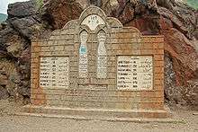
The Karakoram Highway, also known as the Friendship Highway in China, was built by the governments of Pakistan and China. It was started in 1959 and was completed and opened to the public in 1979. About 810 Pakistanis and about 200 Chinese workers lost their lives,[7] mostly in landslides and falls, while building the highway. The Chinese workers who died during the construction are buried in the Chinese cemetery in Gilgit. The route of the KKH traces one of the many paths of the ancient Silk Road.
On the Pakistani side, the road was constructed by FWO (Frontier Works Organisation), employing the Pakistan Army Corps of Engineers. The Engineer-in-Chief's Branch of the Pakistani Army completed a project documenting the history of the highway. The book History of Karakoram Highway was written by Brigadier (Retired) Muhammad Mumtaz Khalid in two volumes. In the first volume the author discusses the land and the people, the pre-historic communication system in the Northern Areas, the need for an all-weather road link with Gilgit, and the construction of Indus Valley Road. The second volume records events leading to the conversion of the Indus Valley Road to the Karakoram Highway, the difficulties in its construction, and the role of Pakistan Army Corps of Engineers and their Chinese counterparts in its construction.[8]
The highway
The highway, connecting the Gilgit–Baltistan region of Kashmir to the ancient Silk Road, runs approximately 1,300 km (810 mi) from Kashgar, a city in the Xinjiang region of China, to Abbottabad, of Pakistan. An extension of the highway southwest from Abbottabad, in the form of the N-35 highway, meets the Grand Trunk Road, N-5, at Hassanabdal, Pakistan.
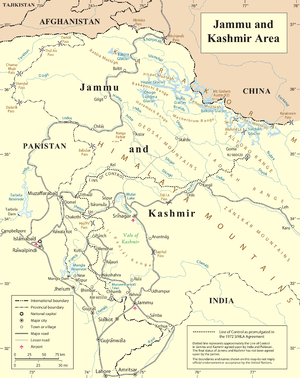
The highway cuts through the collision zone between the Eurasian and Indian plates, where China, Tajikistan, Afghanistan, and Pakistan come within 250 kilometres (160 mi) of each other. Owing largely to the extremely sensitive state of the Kashmir conflict between India and Pakistan, the Karakoram Highway has strategic and military importance to these nations, but particularly Pakistan and China.
On 30 June 2006, a memorandum of understanding was signed between the Pakistani National Highway Authority (NHA) and China's State-owned Assets Supervision and Administration Commission (SASAC) to rebuild and upgrade the Karakoram Highway. According to SASAC, the width will be expanded from 10 to 30 metres (33 to 98 ft), and its transport capacity will be increased three times its current capacity. In addition, the upgraded road will be designed to particularly accommodate heavy-laden vehicles and extreme weather conditions.
China and Pakistan are planning to link the Karakoram Highway to the southern port of Gwadar in Balochistan through the Chinese-aided Gwadar-Dalbandin railway, which extends to Rawalpindi.
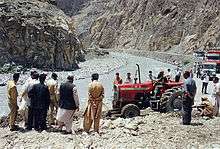
On 4 January 2010, the KKH was closed in the Hunza Valley, eliminating through traffic to China except by small boats. A massive landslide 15 kilometres (9.3 mi) upstream from Hunza's capital of Karimabad created the potentially unstable Attabad Lake, which reached 22 kilometres (14 mi) in length and over 100 metres (330 ft) in depth by the first week of June 2010 when it finally began flowing over the landslide dam. The landslide destroyed parts of villages while killing many inhabitants. The subsequent lake displaced thousands and inundated over 20 kilometres (12 mi) of the KKH including the 310 metres (1,020 ft) long KKH bridge 4 kilometres (2.5 mi) south of Gulmit.[9][10][11]
It is highly questionable whether the lake, which reached 27 kilometres (17 mi) in length in 2011, will drain. Goods from and to further north are transported over the lake by small vessels, to be reloaded onto trucks at the other end.[12] In July 2012 Pakistan began constructing a revised route around the lake at a higher elevation with five new tunnels, with total length of 7.12 km, and two new bridges. The work was contracted out to the China Road & Bridge Corporation (CRBC) and was completed in September 2015—see Karakorum Highway Realignment (China-Pakistan Friendship Tunnels) below.[13]
Pakistani section
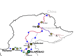
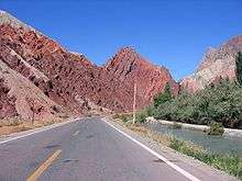
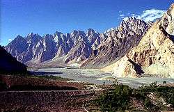
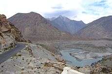
At 806 kilometres (501 mi) in length, the Pakistani section of the highway starts at Abbottabad, although the N-35 of which KKH is now part, officially starts from Hassanabdal. The highway meets the Indus River at Thakot and continues along the river until Jaglot, where the Gilgit River joins the Indus River. This is where three great mountain ranges meet: the Hindukush, the Himalaya, and the Karakoram. The western end of the Himalayas, marked by the ninth highest peak in the world, Nanga Parbat, can be seen from the highway. The highway passes through the capital of Gilgit–Baltistan, Gilgit, and continues through the valleys of Nagar and Hunza, along the Hunza River. Some of the highest mountains and famous glaciers in the Karakoram can be seen in this section. The highway meets the Pakistani-Chinese border at Khunjerab Pass.
Karakoram Highway reconstruction
As part of the $46 billion China Pakistan Economic Corridor, reconstruction and upgrade works on the Pakistani portion of the Karakoram Highway (KKH) are underway. The KKH spans the 887 kilometre long distance between the China-Pakistan border and the town of Burhan, near Hasan Abdal. At Burhan, the existing M1 motorway will intersect the Karakoram Highway at the Shah Maqsood Interchange. From there, access onwards to Islamabad and Lahore continues as part of the existing M1 and M2 motorways, while Burhan will also be at intersection of the Eastern Alignment, and the Western Alignment which will lead towards the port city of Gwadar.
Karakorum Highway Realignment (China-Pakistan Friendship Tunnels)
A large section of the highway was damaged by landslides in 2010 that created Attabad Lake. The resulting landslides cut off both the Indus River and Karakoram Highway resulting in the formation of the reservoir. Prior to completion of the bypass, all vehicular traffic had to be loaded onto barges to traverse the new reservoir. Construction of the tunnels began in 2012 and required 36 months for completion. The 24 km long series of bridges and tunnels was inaugurated on 15 September 2015 at a cost of $275 million and was hailed as a major accomplishment.[14][15] The route comprises 5 tunnels and several bridges. The longest tunnel is 3360m, followed by 2736m, 435m, 410m and 195m, while the Shishkat Great Bridge on Hunza River is 480m long. The realignment restored the road link between Pakistan and China.
Chinese section
The Chinese section of the Karakoram Highway follows the north-south Sarykol ("Yellow Lake") valley just west of the Tarim Basin. The road from Kashgar goes southwest about 80 kilometres (50 mi) and then turns west to enter the Gez (Ghez) River canyon between Chakragil mountain on the north and Kongur mountain on the south. From the Gez canyon the population becomes Kirgiz. Having climbed up to the valley, the road turns south past Kongur, Karakul Lake, and Muztagh Ata on the east. Below Muztagh Ata, a new road goes west over the Kulma Pass to join the Pamir Highway in Gorno-Badakhshan, Tajikistan. The main road continues over a low pass (where the population becomes Tajik) and descends to Tashkurgan. Further south, a valley and jeep track leads west toward the Wakhjir Pass to the Wakhan Corridor. Next the road turns west to a checkpost and small settlement at Pirali, and then the Khunjerab Pass, beyond which is Pakistan, the Khunjerab River and Hunza.

Major towns
- Haripur
- Abbottabad
- Mansehra
- Battagram
- Besham
- Dasu
- Chilas
- Gilgit
- Aliabad
- Gulmit
- Sust
- Tashkurgan (China)
- Upal (China)
- Kashgar, Chinese railhead, 1,435 mm (4 ft 8 1⁄2 in) gauge
Tourism
In recent years the highway has sought to become a 'niche' adventure tourism destination although Pakistan attracts very few international tourists. Only Pakistanis and overseas citizens of Pakistani origin tend to visit these areas, and that too in small numbers. As of 2014, no Western tourist agency offers organised tours to the KKH. Western diplomats based in Pakistan are prohibited by their governments from making personal trips to these areas. The KKH was however ranked in 2006 as the "third best" tourist destination in Pakistan by The Guardian.[16] The road has given mountaineers and cyclists easier access to the many high mountains, glaciers, and lakes in the area. The highway provides access to Gilgit and Skardu from Islamabad by road. These are the two major hubs for mountaineering expeditions in the Gilgit–Baltistan region of Pakistan-administered Kashmir.[17] The Gilgit–Baltistan Administration of Pakistan-administered Kashmir and the Xinjiang Administration of China have signed an agreement to issue border passes to their permanent residents. This pass is valid for a calendar year and is used to travel through Khunjerab Pass only. Karakoram Highway is now one of the most beautiful destination in the world. KKH provides crosss country road trip from Hassan Abdal Pakistan to Kashghar. [18]
Mountains and glaciers
Karakoram Highway provides the pathway to expeditions for almost all peaks in Gilgit–Baltistan, Kashmir and several peaks in Xinjiang China. The region includes some of the world's largest glaciers like the Baltoro Glacier. Five of the Eight-thousanders (mountains taller than 8,000 metres (26,000 ft)) of the world that are in Pakistan are accessible by the highway. The notable mountains that can be directly seen while travelling on the highway are:
- Nanga Parbat, Gilgit–Baltistan, 9th highest of the world at 8,126 metres (26,660 ft)
- Rakaposhi, Gilgit–Baltistan, 27th highest of the world at 7,788 metres (25,551 ft)
- Diran, Gilgit–Baltistan, most dangerous mountain in Pakistan
- Shishpar, Gilgit–Baltistan,
- Ultar Peak, Gilgit–Baltistan,
- Tupopdan, Gilgit–Baltistan,also known as Cathedral Peaks near Passu
Many glaciers can be seen while travelling on the highway:
- Minapin Glacier
- Passu Glacier
- Ghulkin Glacier
- Khunjerab Glacier
Rivers and lakes
Several rivers and lakes are made accessible by the highway. These include:
- Indus River
- Hunza River
- Gilgit River
- Khunjerab River
- Karakul Lake in Xinjiang (China)
Rock art and petroglyphs

There are more than 50,000 pieces of rock art and petroglyphs all along the highway that are concentrated at ten major sites between Hunza and Shatial. The carvings were left by invaders, traders, and pilgrims who passed along the trade route, as well as by locals. The earliest date back to between 5000 and 1000 BC, showing single animals, triangular men, and hunting scenes in which the animals are larger than the hunters. These carvings were pecked into the rock with stone tools and are covered with a thick patina that yields their age.
Travel
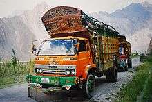
There are several transport companies in Pakistan that offer bus service between major towns of the highway and from Rawalpindi and Lahore. The largest company is Northern Areas Transport Corporation (NATCO). Other companies are Masherbrum Travel, Silk Route Travel, K-2 movers, Anchan Travel, and Saeed Travel.
Bus service between Gilgit and Kashghar
On 1 June 2006, a daily bus service began between Gilgit, Gilgit–Baltistan, and Kashghar, Xinjiang, through the Sust and Tashkorgan border area.[19]
Weather
The KKH is best travelled in the spring or early autumn. Heavy snow during harsh winters can shut the highway down for extended periods. Heavy monsoon rains around July and August cause occasional landslides that can block the road for hours or more. The border crossing between China and Pakistan at Khunjerab Pass is open only between 1 May and 31 December.
See also
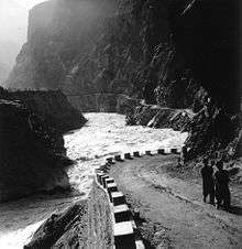
 Landslides often disturb the traffic for several hours. 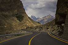 Karakoram Highway ahead of Juglot, Gilgit
|
References
- ↑ Karakoram Hindu Kush
- ↑ Lonely Planet Karakoram Archived 11 October 2012 at the Wayback Machine.
- ↑ It can be argued that the Chile Route 27 is international since it connects to Argentina, and it is 4,810 metres (15,780 ft)
- ↑ World record highways – Karakoram
- ↑ Mahnaz Z. Ispahani (June 1989). Roads and Rivals: The Political Uses of Access in the Borderlands of Asia (First ed.). Cornell University Press. p. 191. ISBN 978-0801422201.
- ↑ Tanveer Naim (2010). "South Asia". UNESCO Science Report (Report). UNESCO. p. 342. ISBN 978-9231041327. Retrieved 18 July 2013.
- ↑ 25th Anniversary of the Karakoram Highway (1978–2003)". Pakistan Post Office, 16 May 2006. Retrieved on 10 July 2006.
- ↑ History of KKH by Brigadier (Retired) Muhammad Mumtaz Khalid
- ↑ Thousands at risk due to Hunza river blockade
- ↑ Search Results rising water threatens villages in hunza ss | Latest news, Breaking news, Pakistan News, World news, business, sport and multimedia | DAWN.COM
- ↑ Blockage of Hunza river, Landslide blog written by Shakeelgilgity, Gilgit-Baltistan
- ↑ Landslide cuts crucial China-Pak road link, hits military supplies – Indian Express
- ↑ Khan, Asghar; Khan, Zulfiqar Ali (27 June 2015). "KKH Re-Alignment: 94% work on the project completed so far, remaining to be completed by Sep. 25 this year". Pamir Times. Archived from the original on 27 June 2015.
- ↑ http://www.dawn.com/news/1206911
- ↑ http://tribune.com.pk/story/956452/pm-inaugurates-tunnel-over-attabad-lake-in-g-b/
- ↑ Windsor, Antonia (17 October 2006). "Out of the rubble". The Guardian. London. Retrieved 7 May 2010.
- ↑ Pakistan and the Karakoram Highway, Owen Bennett-Jones, Lindsay Brown, and John Mock, Lonely Planet Publications; 6 Rev Ed edition (30 Sep 2004), ISBN 0-86442-709-3
- ↑ Karakoram Highway, Road Trip. "Karakoram Highway Cross Country Road Trip". www.skardu.pk. Skardu.pk. Retrieved 23 November 2016.
- ↑ "Kashghar-Gilgit bus service planned". DAWN Newspaper. 23 March 2006. Archived from the original on 15 February 2009.
- ↑ India-China Bhai Bhai revisited
External links
| Wikivoyage has a travel guide for Karakoram Highway. |
| Wikimedia Commons has media related to Karakoram Highway. |
- Video of Karakoram Highway.
- Urdu: Safar Hai Shart A documentary on Karakoram Highway 8th wonder of the world
- History of KKH by Brigadier (Retired) Mumtaz Khalid (Pakistan Army Corps of Engineers)
- Blankonthemap The Northern Kashmir WebSite
- Northern Areas Development Gateway
- Pakistan's Northern Areas
- Karakoram Highway Map
- A good brief description of the highway
- Photographic Account of Journey through KKH
- Karakoram Highway Road Trip Cross Country Adventure In Gilgit Baltistan
| National Highways |
| |||||||
|---|---|---|---|---|---|---|---|---|