Karasjok
| Karasjok kommune Kárášjoga gielda | |||
|---|---|---|---|
| Municipality | |||
 | |||
| |||
 Karasjok within Finnmark | |||
| Coordinates: 69°28′55″N 25°6′18″E / 69.48194°N 25.10500°ECoordinates: 69°28′55″N 25°6′18″E / 69.48194°N 25.10500°E | |||
| Country | Norway | ||
| County | Finnmark | ||
| Administrative centre | Karasjok | ||
| Government | |||
| • Mayor (2015) | Svein Atle Somby (Ap) | ||
| Area | |||
| • Total | 5,452.94 km2 (2,105.39 sq mi) | ||
| • Land | 5,209.45 km2 (2,011.38 sq mi) | ||
| • Water | 243.49 km2 (94.01 sq mi) | ||
| Area rank | 2 in Norway | ||
| Population (2014) | |||
| • Total |
2,698 | ||
| • Rank | 287 in Norway | ||
| • Density | 0.49/km2 (1.3/sq mi) | ||
| • Change (10 years) | -5.8 % | ||
| Demonym(s) | Karasjoking[1] | ||
| Time zone | CET (UTC+1) | ||
| • Summer (DST) | CEST (UTC+2) | ||
| ISO 3166 code | NO-2021 | ||
| Official language form |
Bokmål and Northern Sami | ||
| Website |
www | ||
|
| |||

Karasjok (![]() pronunciation ) or Kárášjohka (Northern Sami) Kaarasjoki (Finnish) is a municipality in Finnmark county, Norway. The administrative centre of the municipality is the village of Karasjok. Other villages include Dorvonjárga, Šuoššjávri, and Váljohka
pronunciation ) or Kárášjohka (Northern Sami) Kaarasjoki (Finnish) is a municipality in Finnmark county, Norway. The administrative centre of the municipality is the village of Karasjok. Other villages include Dorvonjárga, Šuoššjávri, and Váljohka
General information
The municipality of Karasjok was established on 1 January 1866 when it was separated from the old Kistrand municipality. Initially, the population of Karasjok was 515. The municipal borders have not changed since that time.[2]
Name
Karasjok is a Norwegianized form of the Northern Sami language name Kárášjohka. The meaning of the first element could be káráš from Northern Sami which could mean "food plate of wood", or from Finnish, kara, "something that sticks". The last element is johka which means "river".[3]
The name of the municipality was Karasjok until 1990 when it was changed to Kárášjohka-Karasjok.[4] It was the third municipality in Norway to get a Sami name. In 2005, the name was again changed, such that either Kárášjohka or Karasjok can be used.[5]
Coat-of-arms
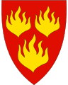
The coat-of-arms is from modern times. They were granted on 27 June 1986. The three gold-colored flames on a red background. The flames were chosen as a symbol for the importance of fire to the local (nomadic) Sami people. The fire brings both heat and thus survival during the harsh winters, but it is also a major threat, both in the tents as well as in the large pine forests. The fire is also the point around which people gather and it is a guard against dangers. The flag contains three flames also because Kárásjoga-Karasjok is a place where three peoples live: the Sami, Norwegians, and Kvens.[6][7]
Churches
The Church of Norway has one parish (sokn) within the municipality of Karasjok. It is part of the Indre Finnmark deanery in the Diocese of Nord-Hålogaland.
| Parish (Sokn) | Church Name | Location of the Church | Year Built |
|---|---|---|---|
| Karasjok | Karasjok Church | Karasjok | 1974 |
| Old Karasjok Church | Karasjok | 1807 | |
| Suosjavrre Chapel | Šuoššjávri | 1968 | |
| Valjok Church | Váljohka | 1932 |
Transportation
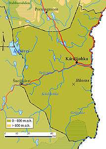
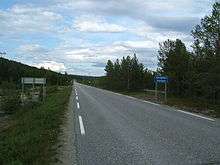
There is an official border crossing between Dorvonjárga (Norway) and Karigasniemi (Finland), over the Anarjohka river. The European route E06 highway passes through the municipality from Lakselv to Tana bru and Kirkenes in the east. The nearest airport is Lakselv Airport, about 80 kilometres (50 mi) from Karasjok village.
Government
All municipalities in Norway, including Karasjok, are responsible for primary education (through 10th grade), outpatient health services, senior citizen services, unemployment and other social services, zoning, economic development, and municipal roads. The municipality is governed by a municipal council of elected representatives, which in turn elect a mayor.
Municipal council
The municipal council (Kommunestyre) of Karasjok is made up of 19 representatives that are elected to every four years. Currently, the party breakdown is as follows:[8]
| Party Name | Name in Norwegian | Number of representatives | |
|---|---|---|---|
| Labour Party | Arbeiderpartiet | 7 | |
| Conservative Party | Høyre | 1 | |
| Christian Democratic Party | Kristelig Folkeparti | 1 | |
| Centre Party | Senterpartiet | 6 | |
| Local Lists | Lokale lister | 4 | |
| Total number of members: | 19 | ||
Geography
The municipality is situated along the upper river basin of the Deatnu / Tana river and its tributaries: Anárjohka and Kárášjohka. It includes large tracts of the high Finnmarksvidda plateau. Lakes in the region include Čorotjávri, Gásadatjávri, Iešjávri, and Idjajávri. The river valley, unlike the plateau, is covered with pine and birch forests. The southern part of the municipality is part of the Øvre Anárjohka National Park.
Climate
| Karasjok | ||||||||||||||||||||||||||||||||||||||||||||||||||||||||||||
|---|---|---|---|---|---|---|---|---|---|---|---|---|---|---|---|---|---|---|---|---|---|---|---|---|---|---|---|---|---|---|---|---|---|---|---|---|---|---|---|---|---|---|---|---|---|---|---|---|---|---|---|---|---|---|---|---|---|---|---|---|
| Climate chart (explanation) | ||||||||||||||||||||||||||||||||||||||||||||||||||||||||||||
| ||||||||||||||||||||||||||||||||||||||||||||||||||||||||||||
| ||||||||||||||||||||||||||||||||||||||||||||||||||||||||||||
In this far northeastern part of Norway, the climate is much more continental and dry compared to the typical coastal climate in Norway.
Situated in a river valley on this plateau, Karasjok has recorded the coldest official temperature ever in Norway: −51.4 °C (−60.5 °F) on 1 January 1886. The warmest temperature ever recorded in the summer is 32.4 °C (90.3 °F). In January 1999, there was also a cold shock, the "official" temperature recording was −51.2 °C (−60.2 °F), but unofficially a temperature of −56 °C (−68.8 °F) was recorded. The warmest month on record was July 1941, with a mean (24hr) temperature of 17.9 °C (64.2 °F); the coldest month was February 1966 with a mean of −27.1 °C (−16.8 °F).
Birdlife
The birdlife to be found in this municipality is characteristic for the region. The inland habitats of Finnmarksvidda are known for their rich bird life with species like Bluethroat preferring areas with scrub. The Tana river also flows through Karasjok and many of the species found in higher areas use it as a migration route.
Economy
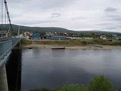
Most people live in the village of Karasjok (Kárášjohka). The village is the seat of the Sámediggi, the Sami Parliament of Norway, as well as of the Sami broadcasting, and several Sami institutions (public and private) are found here. About 80% of the population is Sami speaking, and Sami and Norwegian have equal status in the municipality.
Tourism
The attractions include the Sami parliament, Samediggi, the Sami museum, and the Old Karasjok Church, dating from 1807. The Sami parliament was opened in 1989, by King Olav V, the first Sami parliament president was Ole Henrik Magga, from Kautokeino. He was the president for more than eight years. The Old Karasjok Church is the oldest Lutheran church in Finnmark county, and the only building in the municipality to survive World War II damage. The church is today too small, so a new, larger, wooden Karasjok Church, inspired by Sami architecture, has been built. Karasjok is also the place to look for duodji, Sami handicraft.
References
- ↑ "Navn på steder og personer: Innbyggjarnamn" (in Norwegian). Språkrådet. Retrieved 2015-12-01.
- ↑ Jukvam, Dag (1999). "Historisk oversikt over endringer i kommune- og fylkesinndelingen" (PDF) (in Norwegian). Statistisk sentralbyrå.
- ↑ Store norske leksikon. "Kárášjohka/Karasjok" (in Norwegian). Retrieved 2013-03-31.
- ↑ "Ot.prp. nr. 111 (2001-2002)" (in Norwegian). Regjeringen.no.
- ↑ "Endring av skrivemåten for tospråklige kommuner. Endring av skrivemåten for tospråklige kommunenavn, Kárášjohka-Karasjok" (in Norwegian).
- ↑ Norske Kommunevåpen (1990). "Nye kommunevåbener i Norden". Retrieved 2008-12-10.
- ↑ "Kommunevåpen". Flags of the World. 30 April 2002. Retrieved 2008-12-10. External link in
|publisher=(help) - ↑ "Table: 04813: Members of the local councils, by party/electoral list at the Municipal Council election (M)" (in Norwegian). Statistics Norway. 2015.
External links
 Media related to Karasjok at Wikimedia Commons
 Karasjok travel guide from Wikivoyage
- Karasjok on VisitNorway.com
- Pictures from Karasjok