Kayunga–Galiraya Road
| Kayunga–Galiraya Road | |
|---|---|
| Route information | |
| Length: | 53 mi (85 km) |
| History: |
Expected designation in 2016 Expected completion in 2020 |
| Major junctions | |
| South end: | Kayunga |
| Bbaale | |
| North end: | Galiraya |
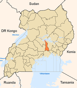
Kayunga–Galiraya Road is a road in the Central Region of Uganda connecting the town of Kayunga to the towns of Bbaale and Galilaya (Galiraya) on the shores of Lake Kyoga.
Location
The road starts at Kayunga, continues north through Bbaale, and ends in Galiraya on the shores of Lake Kyoga, a distance of approximately 85 kilometres (53 mi).[1] The road connects the southern part of Kayunga District to the northern part of the district and forms the main road in the area. It runs in a south to north direction, with River Sezibwa to its west and the Victoria Nile to the road's east. The coordinates of the road near Bbaale are:0°50'49.0"N, 32°52'44.0"E (Latitude:0.846944; Longitude:32.878889).[2]
Upgrading to bitumen
The government of Uganda has earmarked this road for upgrading from gravel to bitumen surface and the building of bridges and drainage channels. In July 2009, the government received funding from the African Development Bank (ADF), to engage consulting engineering firms to conduct detailed feasibility studies.[3][4] The following consulting engineering firms have been shortlisted:[5]
- Aurecon of South Africa
- JBG Gauff Ingeniure of Germany
- TECNIC Consulting Engineers of Spain
- Aarvee Associates of India
- Coda & Partners
As of November 2014, project preparation was ongoing.[6]
See also
References
- ↑ "Approximate Road Distance Between Kayunga And Galiraya With Map". Globefeed.com. Retrieved 2 July 2015.
- ↑ Google (2 July 2015). "Location of Kayunga–Galiraya Road At Bbaale" (Map). Google Maps. Google. Retrieved 2 July 2015.
- ↑ AfDB, . (July 2009). "African Development Fund: Uganda - Road Sector Support Project 3: Project Appraisal Report" (PDF). African Development Bank (AfDB). Retrieved 2 July 2015.
- ↑ UNRA, . (28 July 2009). "Road Sector Support Project (Phase III) In Uganda: Feasibility Study and Detailed Engineering Design". Devex.com. Retrieved 2 July 2015.
- ↑ UNRA, . (4 February 2010). "Shortlisted Bidders for Consultancy Services for Feasibility Studies and Detailed Engineering Design for the Upgrading of Kayunga–Galiraya Road (85Km)" (PDF). Uganda National Roads Authority (UNRA). Retrieved 2 July 2015.
- ↑ Administrator, . (4 November 2014). "UNRA To Begin Works On 16 Roads Next Year". Kampala: Sunrise.ug. Retrieved 2 July 2015.
External links
Capital: Kayunga | ||
| Counties and sub-counties |
|  |
| Towns and villages | ||
| Transport | ||
| Energy | ||
| Health | ||
| Notable landmarks | ||
| Geography | ||
| Education |
| |
| Notable people | ||
Coordinates: 00°50′49″N 32°52′44″E / 0.84694°N 32.87889°E