Kazlų Rūda Municipality
| Kazlų Rūda Municipality Kazlų Rūdos savivaldybė | ||
|---|---|---|
| Municipality | ||
|
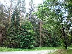
Kazlų Rūda forests | ||
| ||
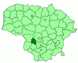 Location of Kazlų Rūda municipality within Lithuania | ||
| Country |
| |
| Ethnographic region | Suvalkija | |
| County | Marijampolė County | |
| Capital | Kazlų Rūda | |
| Elderships | 4 | |
| Area | ||
| • Total | 555 km2 (214 sq mi) | |
| Area rank | 46th | |
| Population (2001 census)[1] | ||
| • Total | 14,900 | |
| • Rank | 55th | |
| • Density | 27/km2 (70/sq mi) | |
| • Density rank | 38th | |
| Time zone | EET (UTC+2) | |
| • Summer (DST) | EEST (UTC+3) | |
| Telephone code | 343 | |
| Major settlements |
| |
| Website |
www | |
.svg.png)
Kazlų Rūda Municipality is one of 60 municipalities in Lithuania.
References
| Municipalities |  | |
|---|---|---|
| Cities | ||
| Towns | ||
| Villages | ||
Coordinates: 54°45′50″N 23°27′50″E / 54.76389°N 23.46389°E
This article is issued from Wikipedia - version of the 5/14/2016. The text is available under the Creative Commons Attribution/Share Alike but additional terms may apply for the media files.