Marijampolė Municipality
| Marijampolė Municipality Marijampolės savivaldybė | ||
|---|---|---|
| Municipality | ||
|
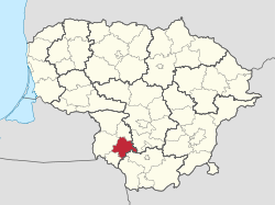
Wetlands and Leciškiai lake | ||
| ||
 Location of Marijampolė municipality within Lithuania | ||
| Country |
| |
| Ethnographic region | Suvalkija | |
| County | Marijampolė County | |
| Capital | Marijampolė | |
| Elderships | 6 | |
| Area | ||
| • Total | 755 km2 (292 sq mi) | |
| Area rank | 44th | |
| Population (2001 census) | ||
| • Total | 70,900 | |
| • Rank | 9th | |
| • Density | 94/km2 (240/sq mi) | |
| • Density rank | 9th | |
| Time zone | EET (UTC+2) | |
| • Summer (DST) | EEST (UTC+3) | |
| Telephone code | 343 | |
| Major settlements |
| |
| Website |
www | |
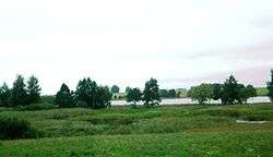
Marijampolė Municipality is one of 60 municipalities in Lithuania.
Marijampolė has a City Council with 27 members. The members of the City Council represent different Lithuanian political parties.
The Marijampolė Municipality is adjacent to the Vilkaviškis District Municipality in the west, Kazlų Rūda Municipality in the north, Kalvarija Municipality in the south, and the Prienai District Municipality and Alytus District Municipality in the east.
The town of Marijampolė and its 6 surrounding communities make up the territory of Marijampolė Municipality. They are: Gudeliai, Igliauka, Liudvinavas, Marijampolė, Sasnava, and Šunskai communities. Marijampolė Municipality covers 755 square kilometres (292 sq mi) of land; 72% of which is an agricultural area, 12.3% is covered by forests; 4.2% – towns and villages, 2% – industrial enterprises and roads, and 6.9% – area used for other purposes.
| Municipalities |  | |
|---|---|---|
| Cities | ||
| Towns | ||
| Villages | ||
Coordinates: 54°33′36″N 23°21′32″E / 54.56000°N 23.35889°E