Kehsi Mansam
| Kehsi Mansam (Kyithi Bansan) | |||||
| State of the Shan States | |||||
| |||||
 | |||||
| Capital | Kehsi | ||||
| History | |||||
| • | Independent from Hsenwi | 1860 | |||
| • | Abdication of the last Myoza | 1959 | |||
| Area | |||||
| • | 1901 | 1,017 km2 (393 sq mi) | |||
| Population | |||||
| • | 1901 | 22,062 | |||
| Density | 21.7 /km2 (56.2 /sq mi) | ||||
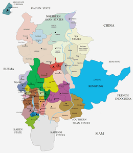
Kehsi Mansam (also known as Kehsi Mangam and as Kyithi Bansan) was a Shan state in what is today Burma. It belonged to the Eastern Division of the Southern Shan States. Its capital was Kehsi town, located by the Nam Heng River. The state included 378 villages and the population was mostly Shan, but there were also some Palaung people (Yins) in the area[1]
History
Kehsi Mansam became independent from Hsenwi State in 1860. It was a tributary of Burma until 1887, when the Shan states submitted to British rule after the fall of the Konbaung dynasty.
Kehsi Mansam included the small substate of Kenglon (Kenglön), located in the southeastern part and almost totally encircled by Kehsi Mansam. In 1926 Kenglon State was incorporated into Kehsi Mansam.[2]
Rulers
The rulers of the state bore the title Myoza.[3]
- 1860 - 1881 Hkun Yawt
- 1881 - 1914 Hkun Yawt Hseng (b. 1844 - d. 1914)
- 1914 - 19.. Hkun Long (b. 1881 - d. 19..)
References
- ↑ Imperial Gazetteer of India, v. 15, p. 196.
- ↑ "WHKMLA : History of the Shan States". 18 May 2010. Retrieved 21 December 2010.
- ↑ Ben Cahoon (2000). "World Statesmen.org: Shan and Karenni States of Burma". Retrieved 21 December 2010.
External links
Coordinates: 22°1′30″N 98°1′0″E / 22.02500°N 98.01667°E