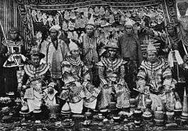
Karenni States
| Karenni States | |||||
| Princely States of British Burma | |||||
| |||||
 | |||||
| Government | Monarchy | ||||
| History | |||||
| • | Independence of the feudatory Karenni predecessor state. | 18th century | |||
| • | Abdication of the Kayah rulers | 1959 | |||
| Area | |||||
| • | 1901 | 8,106 km2 (3,130 sq mi) | |||
| Population | |||||
| • | 1901 | 45,795 | |||
| Density | 5.6 /km2 (14.6 /sq mi) | ||||
| History of Myanmar |
|---|
_peacock.svg.png) |
|
|
|
|
The Karenni States, also known as Karen States, was the name formerly given to the states inhabited mainly by the Red Karen, in the area of present-day Kayah State, northern Burma. They were located south of the Federated Shan States and east of British Burma.
The British government recognised and guaranteed the independence of the Karenni States in an 1875 treaty with Burmese King Mindon Min, by which both parties recognised the area as belonging neither to Burma nor to Great Britain. Consequently, the Karenni States were never fully incorporated into British Burma. The Karenni states formed for a time the "Kayah State" in post-independent Burma,[1] but on 29 April 1959 both the Shan and the Kayah rulers formally surrendered their ruling powers to the Burmese government.[2]
History
There are no historical data on the Karenni States before the 19th century. According to local tradition in the early times of the Karenni states there was a principality led by a "Sawphya" that was under the over lordship of a Shan prince. This state finally became independent in the 18th century. In the 19th century the Karenni state was divided into five principalities (sawphyas).
British rule in Burma
In 1864 a Karenni prince requested the status of British protectorate for his state, but the British authorities did not show any interest. After the death of this prince in 1869 his two sons renewed the petition claiming that they feared Burmese ambitions on their state. The British refused again, but agreed to arbitrate before the King of Burma. Since the Burmese monarchy insisted in their demands on the Karenni territories, the British granted recognition to four states, Kyebogyi, Namekan (Nammekon), Naungpale and Bawlake, which became independent under British protection on 21 June 1875. Kantarawadi state, however, remained independent without official protection.[3]
The Karenni States were recognized as tributary to British Burma in 1892, when their rulers agreed to accept a stipend from the British government. An Assistant Superintendent of the Shan States was based at Loikaw as Agent of the British government. He was exercising control over the local Karenni Rulers, being supervised by the Superintendent at Taunggyi.[3] On 10 October 1922 the administrations of the Karenni states and the Shan states were officially unified to establish the Federated Shan States,[4] under a commissioner who also administered the Wa States. This arrangement survived the constitutional changes of 1923 and 1937. By the 1930s, the Mawchi Mine in Bawlake was one of the most important sources of tungsten in the world.
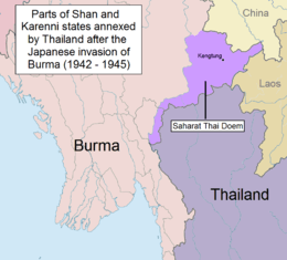
On 27 May 1942, during World War II, nearby Kengtung State was invaded and its capital captured by the Thai Phayap Army.[5] Following a previous agreement between Thai Prime Minister Plaek Phibunsongkhram and the Japanese Empire, in December the same year the Thai administration occupied Kengtung and parts of Möngpan. The annexation by Thailand as Saharat Thai Doem northern province was formalized on 1 August 1943.[2]
Thailand left the territories in 1945, but officially relinquished its claim over the trans-Salween part of Kantarawadi State only in 1946 as part of the condition for admission to the United Nations and the withdrawal of all wartime sanctions for having sided with the Axis powers.[6]
Post-independence Burma
The Constitution of the Union of Burma in 1947 proclaimed that the three Karenni States be amalgamated into a single constituent state of the union, called Karenni State. It also provided for the possibility of secession from the Union after 10 years. In 1952, the former Shan state of Mong Pai was added, and the whole renamed Kayah State, possibly with the intent of driving a wedge between the Karenni in Kayah State and the rest of the Karen people in Karen State, both fighting for independence.
States
There were five Karenni states, divided into two regions.
Western Karenni
The Western Karenni States were the four Karenni states located west of the Salween River:
- Kyebogyi, 350 square miles or 910 square kilometres, population 9,867 in 1901.
- Bawlake, 200 square miles or 520 square kilometres, population 5,701 in 1901.
- Naungpale, 30 square miles or 78 square kilometres, population 1,265 in 1901.
- Nammekon, 50 square miles or 130 square kilometres, population 2,629 in 1901.
Kantarawadi
Kantarawadi State was also known as "Eastern Karenni". It had an area of 2,500 square miles or 6,500 square kilometres and a population of 26,333 in 1901.[3] More than half of its territory was located east of the Salween River, an area that was annexed by Thailand during World War II.
See also
References
- ↑ Map of Shan States c.1910
- 1 2 Shan and Karenni States of Burma
- 1 2 3 Imperial Gazetteer of India, v. 15, p. 36.
- ↑ "Myanmar Divisions". Statoids. Retrieved 10 April 2009.
- ↑ Thailand and the Second World War at the Wayback Machine (archived 27 October 2009)
- ↑ David Porter Chandler & David Joel Steinberg eds. In Search of Southeast Asia: A Modern History. p. 388
External links
Coordinates: 18°30′N 98°00′E / 18.500°N 98.000°E