Hsawnghsup
| Hsawnghsup | |||||
| State of the Shan States | |||||
| |||||
 | |||||
| Capital | Thaungdut | ||||
| History | |||||
| • | State founded | 1757 | |||
| • | Abdication of the last Saopha | 1959 | |||
| Area | |||||
| • | 1901 | 932 km2 (360 sq mi) | |||
| Population | |||||
| • | 1901 | 7,471 | |||
| Density | 8 /km2 (20.8 /sq mi) | ||||
| | |||||
Hsawnghsup was one of the outlying Shan princely states in what is today Burma.
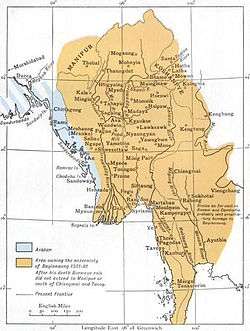
The village of Thaungdut (Hsawnghsup) was formerly the residence of the Sawbwa of Hsawnghsup State. The capital is in the upper end of the Kabaw Valley.[1]
History
Hsawnghsup state was founded in 1757; the first ruler was Sao Kan Po. Little is known of the history of the state before it was annexed to British Burma except that it had been a vassal state of the Kingdom of Burma.[1]
Hsawnghsup formed an exclave located to the northwest of the Shan States, within the Upper Chindwin District of British Burma and bound to the west by the princely state of Manipur. Most of the territory of the state was dense forest.[1] In 1886 the ruler of Hsawnghsup remained loyal to the British during the rebellion of the prince of Wuntho.[2]
Rulers
The rulers of Hsawnghsup bore the title of Saopha.[3]
Saophas
- c.1757 - 1760 Sao Kan Po (d. 1760)
- 1760 - .... Sao Sa
- .... - .... Sao Pon
- .... - 1782 Sao Ti Kyaing
- 1782 - 1813 Sao Haw Nga
- 1813 - 1827 Sao Leik Kan
- 1827 - 1834 Sao Aung Ba -Regent
- 1834 - 22 Oct 1880 Sao Shwe Maung
- 1880 - 1893 Ni Kan
- 1893 - 1899 Sao Kin Mun
- 1899 - 19.. Sao Tun (b. 1860 - d. 19..
References
- 1 2 3 Imperial Gazetteer of India, v. 13, p. 217.
- ↑ The Pacification of Burma, by Sir Charles Haukes Todd Crosthwaite
- ↑ Ben Cahoon (2000). "World Statesmen.org: Shan and Karenni States of Burma". Retrieved 7 July 2014.
External links
- "Gazetteer of Upper Burma and the Shan states"
- The Imperial Gazetteer of India
- "WHKMLA : History of the Shan States". 18 May 2010. Retrieved 21 December 2010.
Coordinates: 24°26′N 94°42′E / 24.433°N 94.700°E