Laihka State
| Laihka (Legya) | |||||
| State of the Shan States | |||||
| |||||
 | |||||
| History | |||||
| • | State founded | 1505 | |||
| • | Abdication of the last Saopha | 1959 | |||
| Area | |||||
| • | 1901 | 3,711 km2 (1,433 sq mi) | |||
| Population | |||||
| • | 1901 | 25,811 | |||
| Density | 7 /km2 (18 /sq mi) | ||||
_(14576785387).jpg)
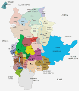
Laihka State (Burmese: Legya) was a state in the central division of the Southern Shan States of Burma, with an area of 3711 km².
The general character of the state was hilly and broken, with a mean altitude of a little under 3000 ft. The main rivers were the Nam Teng, an important tributary of the Salween, and the Nam Pawn. Laihka, located in the plain of the Nam Teng, was the capital where the saopha had his palace (haw).[1] The town of Panglong, where the Panglong Agreement took place, is located close to Laihka.
History
Traditional legends talk about a predecessor kingdom in the area named Hansavadi. Laihka State was founded in 1505 as a state subordinated to Hsenwi State. On the downfall of King Thibaw civil war broke out, and reduced the population to a few hundred. In 1901 it had risen again to 25,811. About seven-ninths of the land under cultivation consisted of wet rice cultivation. A certain amount of upland rice was also cultivated, and cotton, sugarcane and garden produce made up the rest. Laihka, the capital, was noted for its ironwork, both the iron and the implements made being produced at Pang Long in the west of the state. This and lacquerware were the chief exports, as also a considerable amount of pottery. The imports were chiefly cotton piece-goods and salt.[2]
Rulers
The rulers bore the title Myosa until mid nineteenth century.[3]
Myosas
- 1734 - 1794 Khun Lek
- 1794 - 1803 Law Na
- 1803 - 1807 La Hkam
- 1807 - 18.. Hkun Lek
Saohpa
The ritual style was Kambawsa Rahta Mahawunths Thiri Thudamaraza.
- 18.. - 1854 Hkun Lek
- 1854 - 1856 Shwe Ok Hka (Shwe Taung Kyaw)
- 1856 - 1860 Hkun Long
- 1860 - 1862 Sao Hkam Mawng (1st time)
- 1862 - 1866 Hkun Hkawt
- 1866 - 1868 .... (f)
- 1868 - 1879 Sao Hkam Mawng (2nd time)
- 1879 - 1882 Vacant
- 1882 - 1928 Hkun Lai (b. 1858 - d. 1928)
- 1928 - 1952 Sao Num
References
- ↑ Imperial Gazetteer of India, v. 16, p. 118.
- ↑
 This article incorporates text from a publication now in the public domain: Chisholm, Hugh, ed. (1911). "article name needed". Encyclopædia Britannica (11th ed.). Cambridge University Press.
 - ↑ Shan and Karenni States of Burma
External links
Coordinates: 21°16′N 97°39′E / 21.267°N 97.650°E