Kemaliye
| Kemaliye | |
|---|---|
 Kemaliye | |
| Coordinates: 39°15′39″N 38°29′48″E / 39.26083°N 38.49667°ECoordinates: 39°15′39″N 38°29′48″E / 39.26083°N 38.49667°E | |
| Country | Turkey |
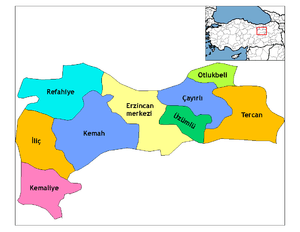
| Province | Erzincan |
| Government | |
| • Mayor | Mustafa Haznedar (AKP) |
| • Kaymakam | Fatih Kaya |
| Area[1] | |
| • District | 1,093.61 km2 (422.25 sq mi) |
| Elevation | 1,130 m (3,710 ft) |
| Population (2012)[2] | |
| • Urban | 2,200 |
| • District | 4,982 |
| • District density | 4.6/km2 (12/sq mi) |
| Post code | 2553x |
| Website |
www |
Kemaliye (formerly Eğin) (Armenian: Ակն, Romanized Old Armenian: Akn, meaning "spring") is both a town in and one of the nine districts of Erzincan Province in the Eastern Anatolia region of Turkey.
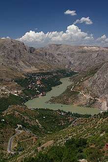
The town is known for its historic architecture, including many Ottoman-era houses. It is also notable for its commanding view of the river Karasu (Euphrates) flowing south through a gorge above the Keban dam.
History
In 1813, James Playfair's "A System of Geography" described Eğin as "[A] little town in the form of an amphitheatre, at the foot of a mountain, in a fruitful tract that reaches to the Euphrates."[3]
The British explorer Francis Rawdon Chesney followed the course of the Euphrates for a survey expedition between 1835 and 1837, and mentions Eğin as "a town of 2700 houses on the right bank". In comparison, he counts about 3000 houses in Erzincan and 2923 families in Malatya. Chesney describes Eğin's situation in a deep valley where the "mountains rise to about 4000 feet on each side of this singular fissure, which is so narrow that it is crossed by a bridge between lofty limestone precipices seeming to overhang the town and as it were to threaten its destruction." [4]
In 1895, the British geographer Charles William Wilson describes Eğin as follows in a travel guide to Asia Minor.[5]
It is a picturesque town, hung in a theatre of rocks so steep and high that there is very short sunlight in the day. An abundant spring, whence the name, rises at the top of the town and supports much vegetation from which the air takes a heavy, moist character. The streets are mere rock ladders. The stone houses standing in the terraced gardens, and orchards, are amongst the best in Anatolia. The bazar is good but there is little outside trade. Cotton cloth (manusa) is manufactured. There is no decent khân and private lodging must be sought. The goitre is a common disease in the district. Of the 10,000 inhabitants, half are Armenians, in whoso largest church is preserved an 11th centy MS. of the Gospels, said to be written by a king of Sasun for his daughter. There are also some good Persian tiles. The spring head and mosque near it are worth seeing. Many of the young men seek work in Constantinople, Smyrna and other towns. They have a high reputation as bankers and money-changers, and are also found as cooks, kaïkjis and hammals at Stambûl. When they have saved enough money they return build a house, and settle down. Egin was one of the places in which the Armenians who emigrated from Vasburagan, with Senekherim, in the 11th centy., settled.
Charles William Wilson (1895). Handbook for Travellers in Asia Minor, Transcaucasia, Persia, Etc. pp. 251–252.
An Ottoman historian Vahakn Dadrian reports that in 1896, the town was evenly divided between Armenians and Muslims (Turks and Kurds). He says that Eğin was notable for its prosperity and had previously escaped the 1895–1896 Hamidian massacres through a ransom payment by the Armenians of 1500 Turkish gold pounds.[6] However, British archaeologist David George Hogarth writing for the 1911 Encyclopædia Britannica noted a massacre of Armenians in Eğin on November 8, 1895.[7]
By 1911, Hogarth described Eğin as an important town in the Mamuretülaziz Vilayet "...picturesquely situated in a theatre of lofty, abrupt rocks, on the right bank of the western Euphrates, which is crossed by a wooden bridge. The stone houses stand in terraced gardens and orchards, and the streets are mere rock ladders."[7]
On 21 October 1922, following the Turkish War of Independence, a decree was issued renaming Eğin as Kemaliye (and Selinti as Gazipaşa) in honor of Mustafa Kemal Pasha. The former name is still known and used locally and sometimes even beyond. Kemaliye was administered as part of Elazığ Province until 1926, and within Malatya Province between 1926 and 1938. In 1938 it was transferred to Erzincan Province.
The 1923 population exchange between Greece and Turkey (Greek: Ἡ Ἀνταλλαγή, Turkish: Mübâdele) stemmed from the "Convention Concerning the Exchange of Greek and Turkish Populations" signed at Lausanne, Switzerland, on 30 January 1923, by the governments of Greece and Turkey, had as result the evacuation of Egin from its Armenian-speaking Greek Orthodox minority population, inhabited there. After a most difficult journey of 8 months and more than a thousand kilometres, they reached the shores of Aegean and were transported (after various stations) in Diavata, near Thessaloniki and Kastaniotissa (new Egin), at the Greek island of Evia.
Notable natives
- Papken Siuni (1873-1896), leader of the Ottoman Bank takeover.
- Siamanto (1878-1915), Armenian writer, poet and national figure arrested on Red Sunday and killed during the Armenian Genocide.
- Nikol Galanderian (1881-1944), Armenian composer of children's songs.
- Hasan Basri Aktan (born 1952), politician; transport minister for Turkey (1999)
- Ahmet Cömert (1926-1990), Turkish boxer, coach, referee, boxing judge and sports official
- Enver Gökçe (born 1920), Turkish poet
- Sait Munzur (born 1959), Turkish cartoonist
- Doğu Perinçek (born 1942), Turkish politician
- Ahmet Kutsi Tecer (1901–1967), Turkish writer, poet and national figure (born in Jerusalem to a father from the village of Apçağa near Eğin)
References
- ↑ "Area of regions (including lakes), km²". Regional Statistics Database. Turkish Statistical Institute. 2002. Retrieved 2013-03-05.
- ↑ "Population of province/district centers and towns/villages by districts - 2012". Address Based Population Registration System (ABPRS) Database. Turkish Statistical Institute. Retrieved 2013-02-27.
- ↑ Playfair, James (1813), A System of Geography, Ancient and Modern, 5, p. 136, retrieved 2 June 2011
- ↑ Chesney, Francis Rawdon (1850). The Expedition for the Survey of the Rivers Euphrates and Tigris. p. 42.
- ↑ Wilson, Charles William (1895). Handbook for Travellers in Asia Minor, Transcaucasia, Persia, Etc. pp. 251–252.
- ↑ Dadrian, Vahakn N. (2003). The History of the Armenian Genocide. Berghahn Books. p. 146. ISBN 1-57181-666-6.
- 1 2
 Hogarth, David George (1911). "Egin". In Chisholm, Hugh. Encyclopædia Britannica. 15 (11th ed.). Cambridge University Press.
External links
| Wikimedia Commons has media related to Kemaliye. |