Tercan
| Tercan | |
|---|---|
|
The Saltukid caravanserai built in the 12th century. | |
 Tercan | |
| Coordinates: 39°46′46″N 40°23′03″E / 39.77944°N 40.38417°ECoordinates: 39°46′46″N 40°23′03″E / 39.77944°N 40.38417°E | |
| Country | Turkey |
| Province | Erzincan |
| Government | |
| • Mayor | Mehmet Yılmaz (MHP) |
| • Kaymakam | Turgay Hakan Bilgin |
| Area[1] | |
| • District | 1,545.54 km2 (596.74 sq mi) |
| Elevation | 1,425 m (4,675 ft) |
| Population (2012)[2] | |
| • Urban | 7,203 |
| • District | 18,613 |
| • District density | 12/km2 (31/sq mi) |
| Post code | 2553x |
| Website |
www |

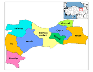
Tercan (formerly Mama Hatun, and Derzene in the Byzantine era) is a town and district of Erzincan Province in the Eastern Anatolia region of Turkey. The district covers an area of 1,592 km2 (615 sq mi) and its total population is 20,072 of which 6,646 live in the town of Tercan.
The town is especially notable for the 12th century complex of buildings built by the Saltukid female ruler Melike Mama Hatun, which comprises her tomb, a mosque, a hammam and an impressive caravanserai which was heavily restored in recent years.
The 17th century Ottoman traveller Evliya Celebi visited the place in 1647, calling it Mamahatun. He wrote about the Saltukid complex and described the town as "a Muslim village containing two hundred houses".[3]
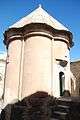 Tomb of Melike Mama Hatun .
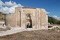 Entrance portal to the tomb complex.
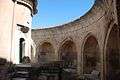 Arches inside the tomb complex.
Sights
- Mama Hatun complex, tomb, caravanserai, mosque and hammam
- Kötür bridge
- Pekeriç fortress
- Abrenk (Vank) church
- Kefrenci temple
See also
References
- ↑ "Area of regions (including lakes), km²". Regional Statistics Database. Turkish Statistical Institute. 2002. Retrieved 2013-03-05.
- ↑ "Population of province/district centers and towns/villages by districts - 2012". Address Based Population Registration System (ABPRS) Database. Turkish Statistical Institute. Retrieved 2013-02-27.
- ↑ Efendi, Evliya; Hammer (Translator), Joseph (1850). Narrative of Travels, Europe, Asia and Africa. London. p. 199.
External links
- (fact sheet) "Mama Hatun Caravanserai, Tercan" Check
|url=value (help). Archnet. - (fact sheet) "Mama Hatun Tomb, Tercan" Check
|url=value (help). Archnet. - Dick Osseman. Photographs: "Tercan" Check
|url=value (help).
This article is issued from Wikipedia - version of the 5/1/2015. The text is available under the Creative Commons Attribution/Share Alike but additional terms may apply for the media files.