Kemi
| Kemi | ||
|---|---|---|
| Town | ||
| Kemin kaupunki Kemi stad | ||
|
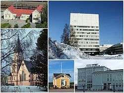
Clockwise, from top: Kemi Railway Station, Kemi City Hall, Karihaara School, Café at the inner harbour, Kemi Church. | ||
| ||
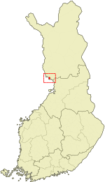 Location of Kemi in Finland | ||
| Coordinates: 65°44′10″N 024°33′49″E / 65.73611°N 24.56361°ECoordinates: 65°44′10″N 024°33′49″E / 65.73611°N 24.56361°E | ||
| Country | Finland | |
| Region | Lapland | |
| Sub-region | Kemi–Tornio sub-region | |
| Charter | 1869 | |
| Government | ||
| • Town manager | Ossi Repo | |
| Area (2011-01-01)[1] | ||
| • Total | 747.44 km2 (288.59 sq mi) | |
| • Land | 95.34 km2 (36.81 sq mi) | |
| • Water | 652.1 km2 (251.8 sq mi) | |
| Area rank | 165th largest in Finland | |
| Elevation | 4 m (13 ft) | |
| Population (2016-03-31)[2] | ||
| • Total | 21,766 | |
| • Rank | 45th largest in Finland | |
| • Density | 228.3/km2 (591/sq mi) | |
| Population by native language[3] | ||
| • Finnish | 98% (official) | |
| • Swedish | 0.1% | |
| • Others | 1.9% | |
| Population by age[4] | ||
| • 0 to 14 | 14.2% | |
| • 15 to 64 | 66.5% | |
| • 65 or older | 19.3% | |
| Time zone | EET (UTC+2) | |
| • Summer (DST) | EEST (UTC+3) | |
| Postal code | 94100 | |
| Municipal tax rate[5] | 20.75% | |
| Website | www.kemi.fi | |
Kemi (Northern Sami: Giepma) is a town and municipality of Finland. It is located very near the city of Tornio. It was founded in 1869 by decree of Russian Emperor Alexander II because of its proximity to a deep water harbour.
Kemi is situated by the Bothnian Bay, at the mouth of river Kemijoki, and it is part of Lapland region. The town has a population of 21,766 (31 March 2016)[2] and covers an area of 747.44 square kilometres (288.59 sq mi) of which 652.1 km2 (251.8 sq mi) is water.[1] The population density is 228.3 inhabitants per square kilometre (591/sq mi).
The main economic activity in Kemi is centred on two large paper and woodpulp mills and on the only chromium mine in Europe (which supplies the Outokumpu ferrochrome plant in Tornio). A polytechnic university of applied sciences is also situated in Kemi.
Kemi also has a claim to fame as the home of the world's largest snow castle (reconstructed every year to a different design). The snowcastle is usually located at the inner harbour of Kemi.
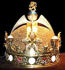
A model of The Crown of Finland (the original was never made for the King of Finland) is kept in the town's gemstone gallery. It also houses replicas of the Imperial State Crown of Great Britain, the Sceptre of the Czar of Russia, the Orbs of Denmark and the diamond necklace of Marie Antoinette, among other items.
Kemi is also the hometown of the power metal band Sonata Arctica.
World War II hostage crisis
During World War II, after Finland signed the Moscow Armistice and found itself involved in the Lapland War with its former German ally, German forces in the beginning of October 1944 captured 132 Finnish civilian hostages from Kemi (as well as 130 from Rovaniemi) and threatened to kill them unless the Finnish army released German POWs captured at the Battle of Tornio. However, the Finns refused to comply and threatened to retaliate by killing the German POWs. The hostages were released unharmed on October 11, 1944, near Rovaniemi.
Sights
- Kemi church
- The SnowCastle of Kemi
- Kemi Gemstone Gallery
- Icebreaker Sampo
- The sailship Jähti
Politics
Results of the Finnish parliamentary election, 2011 in Kemi:
- Left Alliance 28.0%
- True Finns 21.8%
- Social Democratic Party 18.9%
- Centre Party 14.1%
- National Coalition Party 10.7%
- Green League 3.3%
- Christian Democrats 1.5%
- Other parties 1.7%
Economics
In April 2007, the city of Kemi laid off all of its municipal workers for 2 weeks due to the failing economy of the city. Spiraling specialist health care costs and a fleeting industry tax base are stated as the cause for the vote.[6] These are the most drastic temporary dismissals to take place in Finland since 2000.
Transportation
Kemi railway station is an intermediate station on the railway between Lapland and Helsinki. It is operated by VR. The junction of the Kolari and Rovaniemi lines lies to the north of Kemi station.
Finnish national road 4 and European routes E8 and E75 run through the town.
Kemi-Tornio Airport is located 4.5 kilometres (2.8 mi) north of Kemi city centre.
International relations
Twin towns – Sister cities
Kemi is twinned with:
 Tromsø (Norway), since 1940
 Volgograd (Russia), since 1953
 Liptovský Mikuláš (Slovakia)
 Newtownards (United Kingdom)
 Székesfehérvár (Hungary)[7]
 Luleå (Sweden)
Notable residents
- Juhani Paasivirta (1919 – 1993), historian
- Ensio Seppänen (1924 – 2008) sculptor, professor
Gallery
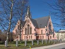 Kemi Church, May 2007
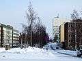 Meripuistokatu street with the Kemi City Hall in the background
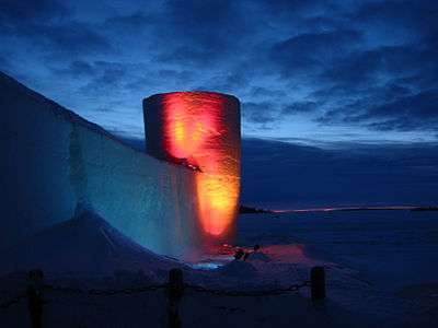 Kemi Snow Castle
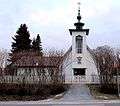 Saint John the Baptist Orthodox Church in Kemi
See also
References
- 1 2 "Area by municipality as of 1 January 2011" (PDF) (in Finnish and Swedish). Land Survey of Finland. Retrieved 9 March 2011.
- 1 2 "Ennakkoväkiluku sukupuolen mukaan alueittain, maaliskuu.2016" (in Finnish). Statistics Finland. Retrieved 31 March 2016.
- ↑ "Population according to language and the number of foreigners and land area km2 by area as of 31 December 2008". Statistics Finland's PX-Web databases. Statistics Finland. Retrieved 29 March 2009.
- ↑ "Population according to age and gender by area as of 31 December 2008". Statistics Finland's PX-Web databases. Statistics Finland. Retrieved 28 April 2009.
- ↑ "List of municipal and parish tax rates in 2011". Tax Administration of Finland. 29 November 2010. Retrieved 13 March 2011.
- ↑ "Northern city of Kemi to lay off all municipal workers for two weeks". Helsingin Sanomat – International Edition. Helsinki: Helsingin Sanomat Oy. 2007-04-24. Retrieved 7 January 2009.
- ↑ Bozsoki, Agnes. "Partnervárosok Névsora Partner és Testvérvárosok Névsora" [Partner and Twin Cities List]. City of Székesfehérvár (in Hungarian). Archived from the original on 2012-12-08. Retrieved 2013-08-05.
External links
| Wikimedia Commons has media related to Kemi. |
- Town of Kemi – Official website
 Kemi travel guide from Wikivoyage
- Kemi SnowCastle – The world's biggest snowcastle
- Sampo Tours – The world's only Arctic Icebreaker for tourist cruises
- Webcam to Snowcastle site (Inner Harbour)
| Municipalities |  | |
|---|---|---|
| Former municipalities | ||