Kendall Park, New Jersey
| Kendall Park, New Jersey | |
|---|---|
| Census-designated place | |
|
Kendall Park along New Road | |
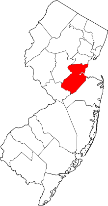
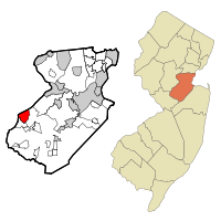 Map of Kendall Park CDP in Middlesex County. Inset: Location of Middlesex County in New Jersey. | |
| Coordinates: 40°24′48″N 74°33′45″W / 40.413404°N 74.562457°WCoordinates: 40°24′48″N 74°33′45″W / 40.413404°N 74.562457°W | |
| Country |
|
| State |
|
| County | Middlesex |
| Township | South Brunswick |
| Named for | Herbert Kendall |
| Area[1] | |
| • Total | 3.704 sq mi (9.594 km2) |
| • Land | 3.702 sq mi (9.589 km2) |
| • Water | 0.002 sq mi (0.006 km2) 0.06% |
| Elevation[2] | 184 ft (56 m) |
| Population (2010 Census)[3] | |
| • Total | 9,339 |
| • Density | 2,522.6/sq mi (974.0/km2) |
| Time zone | Eastern (EST) (UTC-5) |
| • Summer (DST) | Eastern (EDT) (UTC-4) |
| ZIP code | 08824[4] |
| Area code(s) | 732/848 |
| FIPS code | 3430738[1][5] |
| GNIS feature ID | 02389913[1][6] |

Kendall Park is a unincorporated community and census-designated place (CDP) located within South Brunswick Township, in Middlesex County, New Jersey, United States.[7][8][9] As of the 2010 United States Census, the CDP's population was 9,339.[3] Kendall Park has a post office with its own ZIP code (08824) that encompasses the entire CDP, as well as some surrounding areas.[4]
Kendall Park gets its name from its builder, Herbert Kendall, who built a planned community of 1,500 houses between 1956 and 1961.[10] Kendall's development was built in three stages: the initial development in 1956-7 (between New Road and Sand Hill Road), the Constable development in 1959 (south of New Road), followed by the Greenbrook development (north of Sand Hill Road) in 1961. The initial development offered two styles of 3-bedroom, 1½ bath ranch-style homes, mostly built on 1/3 acre lots, typically selling for around $16,000 in 1957. The subsequent sections offered a wider selection of styles, including 4-bedroom ranches and 4-bedroom colonial-style homes. The development of Kendall Park doubled the population of South Brunswick Township and marked the beginning of its transformation from a rural farming area to a suburban bedroom community. Several other nearby tracts developed after Kendall's original development are also part of the CDP.
The Hoagland-Clark House, which dates back to the late 18th century, is a remnant of the earlier era, and was identified by Preservation New Jersey as one of the most vulnerable landmarks in New Jersey.[11]
Geography
According to the United States Census Bureau, the CDP had a total area of 3.704 square miles (9.594 km2), including 3.702 square miles (9.589 km2) of land and 0.002 square miles (0.006 km2) of water (0.06%).[1][12]
Demographics
| Historical population | |||
|---|---|---|---|
| Census | Pop. | %± | |
| 1970 | 7,412 | — | |
| 1980 | 7,419 | 0.1% | |
| 1990 | 7,127 | −3.9% | |
| 2000 | 9,006 | 26.4% | |
| 2010 | 9,339 | 3.7% | |
| Population sources: 1970-1980[13] 1990-2010[7] 2000[14] 2010[3] | |||
Census 2010
At the 2010 United States Census, there were 9,339 people, 3,135 households, and 2,508 families residing in the CDP. The population density was 2,522.6 per square mile (974.0/km2). There were 3,198 housing units at an average density of 863.8 per square mile (333.5/km2). The racial makeup of the CDP was 65.48% (6,115) White, 5.21% (487) Black or African American, 0.18% (17) Native American, 25.08% (2,342) Asian, 0.02% (2) Pacific Islander, 1.73% (162) from other races, and 2.29% (214) from two or more races. Hispanics or Latinos of any race were 6.78% (633) of the population.[3]
There were 3,135 households, of which 43.7% had children under the age of 18 living with them, 68.5% were married couples living together, 8.6% had a female householder with no husband present, and 20.0% were non-families. 17.2% of all households were made up of individuals, and 8.1% had someone living alone who was 65 years of age or older. The average household size was 2.98 and the average family size was 3.39.[3]
In the CDP, 27.7% of the population were under the age of 18, 6.6% from 18 to 24, 23.6% from 25 to 44, 30.3% from 45 to 64, and 11.8% who were 65 years of age or older. The median age was 40.5 years. For every 100 females there were 93.5 males. For every 100 females age 18 and over, there were 91.9 males.[3]
Census 2000
As of the 2000 United States Census[5] there were 9,006 people, 3,013 households, and 2,431 families residing in the CDP. The population density was 934.7/km2 (2,418.4/mi2). There were 3,094 housing units at an average density of 321.1/km2 (830.8/mi2). The racial makeup of the CDP was 79.31% White, 4.53% African American, 0.02% Native American, 13.19% Asian, 0.06% Pacific Islander, 0.97% from other races, and 1.92% from two or more races. Hispanic or Latino of any race were 4.34% of the population.[14]
There were 3,013 households out of which 45.4% had children under the age of 18 living with them, 69.7% were married couples living together, 7.6% had a female householder with no husband present, and 19.3% were non-families. 16.4% of all households were made up of individuals and 7.7% had someone living alone who was 65 years of age or older. The average household size was 2.99 and the average family size was 3.37.[14]
In the CDP the population was spread out with 29.9% under the age of 18, 5.3% from 18 to 24, 32.4% from 25 to 44, 21.6% from 45 to 64, and 10.8% who were 65 years of age or older. The median age was 36 years. For every 100 females there were 94.9 males. For every 100 females age 18 and over, there were 92.3 males.[14]
The median income for a household in the CDP was $74,438, and the median income for a family was $82,324. Males had a median income of $59,955 versus $40,146 for females. The per capita income for the CDP was $26,986. About 2.0% of families and 2.9% of the population were below the poverty line, including 2.1% of those under age 18 and 9.8% of those age 65 or over.[14]
Education
Cambridge, Constable, Greenbrook, and Brunswick Acres are all elementary schools located within Kendall Park that are part of the South Brunswick Public Schools.
St. Augustine of Canterbury School is PreK-8 elementary school operating under the auspices of the Roman Catholic Diocese of Metuchen.[15][16] In 2016, the school was one of ten schools in New Jersey, and one of private schools, recognized as a National Blue Ribbon School by the United States Department of Education, a recognition celebrating excellence in academics.[17][18]
References
- 1 2 3 4 Gazetteer of New Jersey Places, United States Census Bureau. Accessed July 21, 2016.
- ↑ U.S. Geological Survey Geographic Names Information System: Kendall Park Census Designated Place, Geographic Names Information System. Accessed November 29, 2012.
- 1 2 3 4 5 6 DP-1 - Profile of General Population and Housing Characteristics: 2010 Demographic Profile Data for Kendall Park CDP, New Jersey, United States Census Bureau. Accessed November 29, 2012.
- 1 2 Look Up a ZIP Code for Kendall Park, NJ, United States Postal Service. Accessed November 29, 2012.
- 1 2 American FactFinder, United States Census Bureau. Accessed September 4, 2014.
- ↑ US Board on Geographic Names, United States Geological Survey. Accessed September 4, 2014.
- 1 2 New Jersey: 2010 - Population and Housing Unit Counts - 2010 Census of Population and Housing (CPH-2-32), United States Census Bureau, August 2012. Accessed November 29, 2012.
- ↑ GCT-PH1 - Population, Housing Units, Area, and Density: 2010 - County -- County Subdivision and Place from the 2010 Census Summary File 1 for Middlesex County, New Jersey, United States Census Bureau. Accessed November 29, 2012.
- ↑ Locality Search, State of New Jersey. Accessed April 18, 2015.
- ↑ Cheslow, Jerry. "If You're Thinking of Living in: South Brunswick", The New York Times, November 22, 1992. Accessed November 29, 2012.
- ↑ 10 Most Endangered Historic Sites in New Jersey 2010: Hoagland-Clark House, Preservation New Jersey. Accessed November 29, 2012.
- ↑ US Gazetteer files: 2010, 2000, and 1990, United States Census Bureau. Accessed September 4, 2014.
- ↑ Staff. 1980 Census of Population: Number of Inhabitants United States Summary, p. 1-141. United States Census Bureau, June 1983. Accessed January 12, 2012.
- 1 2 3 4 5 DP-1 - Profile of General Demographic Characteristics: 2000 from the Census 2000 Summary File 1 (SF 1) 100-Percent Data for Kendall Park CDP, New Jersey, United States Census Bureau. Accessed November 29, 2012.
- ↑ About St. Augustine School, Saint Augustine of Canterbury School. Accessed November 13, 2016.
- ↑ St. Augustine of Canterbury School, Roman Catholic Diocese of Metuchen. Accessed November 13, 2016.
- ↑ 2016 National Blue Ribbon Schools All Public and Non‐Public, National Blue Ribbon Schools Program. Accessed November 13, 2016.
- ↑ Clark, Adam. "These 10 N.J. schools earn Blue Ribbon honors", NJ Advance Media for NJ.com, September 28, 2016. Accessed November 13, 2016. "The U.S. Department of Education on Wednesday announced that 10 New Jersey schools have been named National Blue Ribbon Schools, a recognition celebrating excellence in academics."