Kendrick Mountain Wilderness
| Kendrick Mountain Wilderness | |
|---|---|
|
IUCN category Ib (wilderness area) | |
 | |
| Location | Coconino County, Arizona, U.S. |
| Nearest city | Flagstaff, Arizona |
| Coordinates | 35°24′49″N 111°51′16″W / 35.41361°N 111.85444°WCoordinates: 35°24′49″N 111°51′16″W / 35.41361°N 111.85444°W |
| Area | 6,510 acres (26.3 km2) |
| Established | 1984 |
| Governing body | Bureau of Land Management |
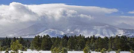
Kendrick Mountain Wilderness is a 6,510-acre (26.3 km2) wilderness area in the U.S. State of Arizona. It lies north of the city of Flagstaff on the Coconino Plateau in Coconino County. Kendrick Mountain Wilderness was designated a protected Wilderness area by Congress in 1984. About two thirds of the wilderness is contained within the Kaibab National Forest. Kendrick Mountain Wilderness contains 10,418-foot (3,175 m) Kendrick Peak, upon which a fire lookout has been located since the early 1900s.
In the year 2000 the Kendrick Wilderness and Kendrick Peak were substantially affected by a 15,000 acre (61 km2) wildfire, known as the "Pumpkin Fire", the results of which are still quite evident to hikers or visitors to the peak. In an effort to return the forest to its "pre-fire" state, cattle are sometimes grazed near the Kendrick Mountain Trail trailhead.
See also
External links
- Kendrick Wilderness provided by Wilderness.net
- Kendrick Wilderness provided by USDA Forest Service