Kenley, Shropshire
| Kenley | |
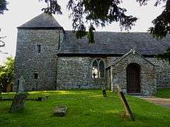 St John the Baptist church, Kenley |
|
 Kenley |
|
| Population | 258 (2011) |
|---|---|
| OS grid reference | SJ561005 |
| Civil parish | Kenley |
| Unitary authority | Shropshire |
| Ceremonial county | Shropshire |
| Region | West Midlands |
| Country | England |
| Sovereign state | United Kingdom |
| Post town | SHREWSBURY |
| Postcode district | SY5 |
| Dialling code | 01694 |
| Police | West Mercia |
| Fire | Shropshire |
| Ambulance | West Midlands |
| EU Parliament | West Midlands |
| UK Parliament | Shrewsbury and Atcham |
|
|
Coordinates: 52°36′04″N 2°38′53″W / 52.601°N 2.648°W
Kenley is a small village and civil parish in the English county of Shropshire. It is located in remote countryside, atop a ridge at around 180 metres (590 ft) above sea level. It is near the larger villages of Acton Burnell, about three miles to the north-west, and Harley, about two miles to the east. The population of the civil parish at the 2011 census was 258.[1]
The name is probably formed from the Old English personal name Cenna with -ley, meaning a clearing in a wood.[2]
To the west are the hamlets of Ruckley and Langley, which form a separate civil parish.
The historian Archibald Alison and statistician William Farr were born in Kenley.
Notable People
- Archibald Alison, (1757-1839), Scots essayist, onetime parish rector.
- Sir Archibald Alison, 1st Baronet, (1792-1867), historian and advocate, his son
- William Farr, (1807-1883), statistician
References
- ↑ "Civil Parish population 2011". Retrieved 27 November 2015.
- ↑ Raven, M. A Guide to Shropshire, 2005, p.102
External links
![]() Media related to Kenley, Shropshire at Wikimedia Commons
Media related to Kenley, Shropshire at Wikimedia Commons
| Unitary authorities | |
|---|---|
| Major settlements | |
| Rivers | |
| Canals | |
| Topics | |