Kennard, Texas
| Kennard, Texas | |
|---|---|
| City | |
|
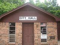
Kennard City Hall building (established 1978) | |
 Location of Kennard, Texas | |
 | |
| Coordinates: 31°21′21″N 95°11′7″W / 31.35583°N 95.18528°WCoordinates: 31°21′21″N 95°11′7″W / 31.35583°N 95.18528°W | |
| Country | United States |
| State | Texas |
| County | Houston |
| Area | |
| • Total | 1.3 sq mi (3.3 km2) |
| • Land | 1.3 sq mi (3.3 km2) |
| • Water | 0.0 sq mi (0.0 km2) |
| Elevation | 361 ft (110 m) |
| Population (2000) | |
| • Total | 317 |
| • Density | 250.5/sq mi (96.7/km2) |
| Time zone | Central (CST) (UTC-6) |
| • Summer (DST) | CDT (UTC-5) |
| ZIP code | 75847 |
| Area code(s) | 936 |
| FIPS code | 48-38884[1] |
| GNIS feature ID | 1360574[2] |

Kennard (/kᵻˈnɑːrd/ kə-NARD) is a city in Houston County, Texas, United States. The population was 317 at the 2000 census. The main street is Texas State Highway 7.
The First Baptist Church of Kennard, established in 1903, has over the years been involved in anti-liquor and anti-gambling campaigns.[3]
Geography
Kennard is located at 31°21′21″N 95°11′7″W / 31.35583°N 95.18528°W (31.355866, -95.185384).[4]
According to the United States Census Bureau, the city has a total area of 1.3 square miles (3.4 km2), all of it land.
Demographics
| Historical population | |||
|---|---|---|---|
| Census | Pop. | %± | |
| 1970 | 448 | — | |
| 1980 | 424 | −5.4% | |
| 1990 | 341 | −19.6% | |
| 2000 | 317 | −7.0% | |
| 2010 | 337 | 6.3% | |
| Est. 2015 | 323 | [5] | −4.2% |
As of the census[1] of 2000, there were 317 people, 123 households, and 83 families residing in the city. The population density was 250.5 people per square mile (96.4/km²). There were 159 housing units at an average density of 125.7/sq mi (48.3/km²). The racial makeup of the city was 74.45% White, 21.77% African American, 0.95% Asian, 1.58% from other races, and 1.26% from two or more races. Hispanic or Latino of any race were 2.84% of the population.
There were 123 households out of which 30.9% had children under the age of 18 living with them, 48.0% were married couples living together, 13.0% had a female householder with no husband present, and 32.5% were non-families. 30.1% of all households were made up of individuals and 13.8% had someone living alone who was 65 years of age or older. The average household size was 2.58 and the average family size was 3.17.
In the city the population was spread out with 28.4% under the age of 18, 12.0% from 18 to 24, 25.2% from 25 to 44, 22.7% from 45 to 64, and 11.7% who were 65 years of age or older. The median age was 33 years. For every 100 females there were 93.3 males. For every 100 females age 18 and over, there were 94.0 males.
The median income for a household in the city was $28,125, and the median income for a family was $37,917. Males had a median income of $24,722 versus $25,625 for females. The per capita income for the city was $19,354. About 16.4% of families and 24.3% of the population were below the poverty line, including 39.7% of those under age 18 and 23.7% of those age 65 or older.
Education
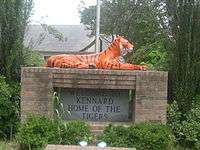
The City of Kennard is served by the Kennard Independent School District. The Kennard High School teams are known as the Tigers.
Climate
The climate in this area is characterized by hot, humid summers and generally mild to cool winters. According to the Köppen Climate Classification system, Kennard has a humid subtropical climate, abbreviated "Cfa" on climate maps.[7]
References
- 1 2 "American FactFinder". United States Census Bureau. Retrieved 2008-01-31.
- ↑ "US Board on Geographic Names". United States Geological Survey. 2007-10-25. Retrieved 2008-01-31.
- ↑ Texas Historical Commission, historical marker, First Baptist Church of Kennard
- ↑ "US Gazetteer files: 2010, 2000, and 1990". United States Census Bureau. 2011-02-12. Retrieved 2011-04-23.
- ↑ "Annual Estimates of the Resident Population for Incorporated Places: April 1, 2010 to July 1, 2015". Retrieved July 2, 2016.
- ↑ "Census of Population and Housing". Census.gov. Retrieved June 4, 2015.
- ↑ Climate Summary for Kennard, Texas
External links
- Houston County and Crockett Area Chamber of Commerce
- The interactive community website of Houston County, Texas
Municipalities and communities of Houston County, Texas, United States | ||
|---|---|---|
| Cities |  | |
| Unincorporated communities |
| |
| Ghost towns |
| |
| Footnotes | ‡This populated place also has portions in an adjacent county or counties | |