Kent, Oregon
| Kent, Oregon | |
|---|---|
| Unincorporated community | |
|
Old grain elevator in Kent | |
 Kent, Oregon  Kent, Oregon | |
| Coordinates: 45°11′42″N 120°41′39″W / 45.19500°N 120.69417°WCoordinates: 45°11′42″N 120°41′39″W / 45.19500°N 120.69417°W | |
| Country | United States |
| State | Oregon |
| County | Sherman |
| Elevation | 2,713 ft (827 m) |
| Time zone | Pacific (PST) (UTC-8) |
| • Summer (DST) | PDT (UTC-7) |
| ZIP code | 97033 |
| Area code(s) | 458 and 541 |
| GNIS feature ID | 1122693[1] |
_(sheD0049).jpg)
Kent is an unincorporated community in Sherman County, Oregon, United States.[1] Although it is unincorporated, Kent has a post office with a ZIP code of 97033.[2] Kent lies at the intersection of U.S. Route 97 and Dobie Point Road, between Grass Valley to the north and Shaniko to the south.[3]
Kent was the site of a railway station, originally called Guthrie, on the Columbia Southern Railway. The name of the community stemmed either from a drawing from a group of names submitted by local residents or was chosen directly by Kent's first postmaster, according to differing accounts of the matter. Milton H. Bennett was that postmaster, who ran the post office beginning in about 1887.[4]
Climate
This region experiences warm (but not hot) and dry summers, with no average monthly temperatures above 68.1 °F (20.1 °C). According to the Köppen Climate Classification system, Kent has a steppe climate, abbreviated "BSk" on climate maps.
| Climate data for Kent, Oregon | |||||||||||||
|---|---|---|---|---|---|---|---|---|---|---|---|---|---|
| Month | Jan | Feb | Mar | Apr | May | Jun | Jul | Aug | Sep | Oct | Nov | Dec | Year |
| Record high °F (°C) | 63 (17) |
69 (21) |
77 (25) |
89 (32) |
97 (36) |
103 (39) |
107 (42) |
108 (42) |
102 (39) |
92 (33) |
77 (25) |
65 (18) |
108 (42) |
| Average high °F (°C) | 37.5 (3.1) |
42.9 (6.1) |
50.5 (10.3) |
57.8 (14.3) |
66.5 (19.2) |
74.2 (23.4) |
83.8 (28.8) |
83 (28) |
74.3 (23.5) |
62.4 (16.9) |
47.2 (8.4) |
39.5 (4.2) |
60 (16) |
| Average low °F (°C) | 22.9 (−5.1) |
26.7 (−2.9) |
30.5 (−0.8) |
34.1 (1.2) |
40 (4) |
46.2 (7.9) |
52.2 (11.2) |
52 (11) |
45.9 (7.7) |
38 (3) |
30 (−1) |
25.3 (−3.7) |
37 (3) |
| Record low °F (°C) | −17 (−27) |
−19 (−28) |
5 (−15) |
14 (−10) |
21 (−6) |
26 (−3) |
32 (0) |
36 (2) |
21 (−6) |
9 (−13) |
−10 (−23) |
−18 (−28) |
−19 (−28) |
| Average precipitation inches (mm) | 1.4 (36) |
1.08 (27.4) |
1 (30) |
0.93 (23.6) |
1.02 (25.9) |
0.87 (22.1) |
0.35 (8.9) |
0.38 (9.7) |
0.57 (14.5) |
0.87 (22.1) |
1.47 (37.3) |
1.48 (37.6) |
11.42 (290.1) |
| Average snowfall inches (cm) | 7 (18) |
3.9 (9.9) |
2.1 (5.3) |
0.7 (1.8) |
0 (0) |
0 (0) |
0 (0) |
0 (0) |
0.1 (0.3) |
0.2 (0.5) |
2.2 (5.6) |
5.2 (13.2) |
21.3 (54.1) |
| Average precipitation days | 10 | 9 | 9 | 8 | 7 | 6 | 2 | 3 | 4 | 7 | 10 | 9 | 84 |
| Source: [5] | |||||||||||||
References
- 1 2 "Kent". Geographic Names Information System. United States Geological Survey. November 28, 1980. Retrieved November 2, 2016.
- ↑ "Search Results for Kent, Oregon". CD Light. 2016. Retrieved November 2, 2016.
- ↑ Oregon Atlas & Gazetteer (7th ed.). Yarmouth, Maine: DeLorme. 2008. p. 72. ISBN 978-0-89933-347-2.
- ↑ McArthur, Lewis A.; McArthur, Lewis L. (2003) [1928]. Oregon Geographic Names (7th ed.). Portland, Oregon: Oregon Historical Society Press. p. 530. ISBN 978-0875952772.
- ↑ "Kent, OR (354411)". Western Regional Climate Center. Retrieved November 26, 2015.
Municipalities and communities of Sherman County, Oregon, United States | ||
|---|---|---|
| Cities | 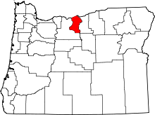 | |
| CDP | ||
| Other communities | ||