Kew, Victoria
| Kew Melbourne, Victoria | |||||||||||||
|---|---|---|---|---|---|---|---|---|---|---|---|---|---|
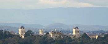
 Aerial view over northern residential parts of Kew looking southwest showing Studley Park (top); Kew Asylum (right) and Eastern Freeway Earl Street exit (bottom right) | |||||||||||||
 Kew | |||||||||||||
| Coordinates | 37°48′19″S 145°2′9″E / 37.80528°S 145.03583°ECoordinates: 37°48′19″S 145°2′9″E / 37.80528°S 145.03583°E | ||||||||||||
| Population | 23,876 (2011 census)[1] | ||||||||||||
| • Density | 2,274/km2 (5,889/sq mi) | ||||||||||||
| Postcode(s) | 3101 | ||||||||||||
| Area | 10.5 km2 (4.1 sq mi) | ||||||||||||
| Location | 6 km (4 mi) from Melbourne | ||||||||||||
| LGA(s) | City of Boroondara | ||||||||||||
| State electorate(s) | Kew | ||||||||||||
| Federal Division(s) | Kooyong | ||||||||||||
| |||||||||||||
Kew is a suburb of Melbourne, Australia, 6 km east from Melbourne's Central Business District. Its local government area is the City of Boroondara. At the 2011 Census, Kew had a population of 23,876.[2] Kew used to be a city in its own right. But in 1994 the cities of Kew, Hawthorn and Camberwell were amalgamated to form the City of Boroondara. The suburb borders the Yarra River to the west and north, with Hawthorn to its south and Balwyn to its east.
History

Prior to the establishment of Melbourne, the area was inhabited by the Wurundjeri peoples. In the 1840s European settlers named it the Parish of Boroondara – meaning "a place of shade" in the Woiwurrung language. In 1838 Dight travelled down the Yarra from Heidelberg and decided to locate a water-powered mill on a site adjacent to the falls; the impressive three-storey mill opened in 1840.[3]
John Hodgson established a squatters run at Studley Park, on the eastern bank of the Yarra River, in 1840. Studley House, also known as Burke Hall, built in 1857, was named after Hodgson's birthplace of Studley, Yorkshire and the house is now on the Register of the National Estate.[4] The house was built in the Victorian Period Italianate Revival style. Modifications were made to the house in 1875 and 1919. The house was also owned by former bookmaker, ALP lobbyist, influential Irish-Catholic and millionaire, John Wren and was donated to Xavier College by the land developer T. M. Burke. It illustrates the importance of a residence in indicating success and status in nineteenth and early twentieth century Melbourne society. The nearby Villa Alba, built before 1863,[5] is open to the public.[6]
In 1851, Crown land sales occurred in the area. One of the purchasers, Nicholas Fenwick, subdivided his land (which was just further out from the center of the colony of Melbourne than the area known as Richmond) and named the region Kew, based on the thought that Kew in England was near Richmond. He also notably named its streets after British statesmen. The area quickly became a sought-after suburb for the well-to-do in Melbourne. Access to Kew was originally via Bridge Road in Richmond, crossing the Hawthorn Bridge to Burwood Road, until the privately owned Studley Park Bridge (nicknamed the Penny Bridge) opened in 1857,[7] connecting Church Street Richmond with Studley Park.
The commercial precinct known as Kew Junction began to take shape in the 1850s. The first store was opened by Mr. J. J. French in August 1853 and the first post office on 6 October 1856,[8] however, it was not till towards the end of the decade that many shops appeared in High Street. The Kew Hotel opened in 1855, the Prospect Hill Hotel (now the Dan Murphy's liquor store) in 1857, the Council Hotel about 1860, the Clifton (now Hotel Kew) in 1869 and the Greyhound (now the Skinny Dog Hotel) in 1874. The block of civic buildings comprising the former post office, the former court house and the former police station were built in 1888 as was the National Bank, at the corner of Walpole and High Streets.[9]
In 1856 a site was reserved for a mental asylum next to the river. By 1871 Kew Lunatic Asylum, now known as Willsmere Estate, was completed. The Kew Cottages for children were added in 1887. The hospital was built despite objections by residents and the Kew Borough Council[10] and provides an historical example of NIMBYism. Kew Cottages and Willsmere Hospital are listed on the Victorian Heritage Register.
Various churches opened in the 1850s, with the first school opened by the Anglican Church in 1856. In 1875 Sacred Heart Primary School was opened. More private schools were opened in 1878, including Ruyton Girls' School (non-denominational) and Xavier College (Catholic in Jesuit order). Other private schools soon followed, including Methodist Ladies' College (Methodist) in 1882, Genazzano FCJ College in 1889, Trinity Grammar School (Anglican) in 1903, and Carey Baptist Grammar School (Baptist) in 1923. Preshil, The Margaret Lyttle Memorial School, was opened in the early 1930s. By 1990, Kew had six government campuses and twenty-eight non-government campuses, the highest concentration of education institutions in the Western world.
A railway branch line to Kew from Hawthorn Station opened on 19 December 1887 and was officially closed on 13 May 1957.[11] Kew was proclaimed a town on 8 December 1910, and a city on 10 March 1921. The population of the area tripled between 1910 and World War II.
Raheen
Raheen is a historic 19th-century Italianate mansion, located at 92 Studley Park Road. It was built in the 1870s,[12] and its name means "little fort" in Irish.
Raheen was once the residence of Daniel Mannix, the former Catholic Archbishop of Melbourne[13] and was bequeathed to the Catholic Church by John Wren.
It was purchased in 1980 by the Australian businessman Richard Pratt and his family and is not currently open to the public. Pratt extensively renovated the house and gardens, including the addition of a new wing, designed by Glen Murcutt.[12]
Today
Kew has grown steadily since the early Bridge Road crossing development and is cited as one of the most prestigious suburbs in Melbourne.[14] As a consequence, many of these residences now attract some of the highest residential resale values in Melbourne.[15]
Streets in the Sackville Ward (bounded by Barkers, Burke, Cotham and Glenferrie Roads), such as Alfred, Rowland, Wellington, Grange and Sackville, have some exceptional examples of Edwardian, Victorian and contemporary architecture.
Kew has convenient access to public facilities and transport. The 109, 16 and 72 along with tram route 48 (North Balwyn – Victoria Harbour Docklands) tram routes pass through the suburb and the City/Lilydale/Belgrave train line is easily accessed at Hawthorn and Glenferrie Stations. Kew Station and the associated railway branch was last served by passenger trains in 1952,[11] with the station site now the headquarters of VicRoads.
There are also two Scout groups: 1st Kew and 4th Kew. In the mid-1900s there were up to seven, however only those two remained.
Demographics
67.6% of Kew residents were born in Australia. The most common countries of birth other than Australia are China (excluding SARs and Taiwan) 3.6%, England 3.3%, Malaysia 1.8%, India 1.7% and New Zealand 1.6%.
Education
- Kew Primary School
- Sacred Heart Primary School
- Carey Baptist Grammar School
- Genazzano FCJ College
- Methodist Ladies' College
- Preshil
- Ruyton Girls' School
- Trinity Grammar School
- Xavier College
- Kew High School
Sport
Golfers have the choice of membership at Green Acres Golf Club,[16] or Kew Golf Club, in Kew East,[17] or may play at the Studley Park Par 3 Golf Course, on Studley Park Road.[18]
Kew Football Club plays out of Victoria Park, on High Street.
Transport
Tram
- 16 Kew – St Kilda Beach – Melbourne University (via City and St Kilda)
- 48 North Balwyn (Doncaster Road / Balwyn Road) – City (Docklands).
- 72 Camberwell (Burke Road / Cotham Road) – Melbourne University.
- 109 Box Hill – Port Melbourne (via Collins Street).
Bus
- 200 – City (Queen St) – Bulleen, Victoria via Kew Junction
- 207 – City (Queen St) – Doncaster Shoppington via Kew Junction
- 302 - City (Lonsdale St) - Box Hill via Belmore Road and Eastern Freeway
- 304 - City (Lonsdale St) - Doncaster Shoppington via Belmore Road and Eastern Freeway
- 548 – Kew (Cotham Road) – La Trobe University Bundoora
- 609 – Hawthorn to Fairfield via Kew
- 624 – Kew – Oakleigh via Caulfield, Carnegie or Darling, and Chadstone
Notable people

- Gough Whitlam – 21st Prime Minister of Australia born at 'Ngara' 46 Rowland St.
- David Syme- owner of The Age and associated newspapers
- Michael Klinger – cricketer
- Graham Kinniburgh – Australian organised crime figure
- Kyrie Irving – NBA basketballer for the Cleveland Cavaliers
- Glenn Maxwell – cricketer
- Gustav Nossal – scientist and Australian of the Year
- MacFarlane Burnet – virologist and Nobel Laureate
- Jack Gervasoni – footballer and Mayor of Kew
- John Wren – businessman
- Rupert Hamer – Premier of Victoria
- Peter MacCallum – pathologist
- Peter Curran – footballer
- Robert DiPierdomenico – footballer
- Cecil Austen – footballer
- Phil Ryan (footballer born 1915) – footballer
- Irene Crespin – geologist
- Wendy Smith (politician) – politician
- Peter McIntyre (architect) – architect
- Clement Roy Nichols – Scouting
See also
- City of Kew – the former local government area
References
- ↑ Australian Bureau of Statistics (25 October 2007). "Kew (State Suburb)". 2006 Census QuickStats. Retrieved 22 July 2012.
- ↑ "2011 Census QuickStats – Kew (Vic.)". Australian Bureau of Statistics. Retrieved 16 March 2014.
- ↑ St. Paul's Anglican Church Online History
- ↑ "Studley House, Victorian Heritage Register (VHR) Number H0789, Heritage Overlay HO101". Victorian Heritage Database. Heritage Victoria.
- ↑ "Villa Alba, Victorian Heritage Register (VHR) Number H0605, Heritage Overlay HO134". Victorian Heritage Database. Heritage Victoria.
- ↑ http://www.villaalbamuseum.org/
- ↑ "OPENING OF STUDLEY PARK BRIDGE". The Argus. Melbourne: National Library of Australia. 6 June 1857. p. 6. Retrieved 3 January 2012.
- ↑ Premier Postal History. "Post Office List". Retrieved 11 April 2008.
- ↑ "The Jubilee History of Kew, Victoria : Its Origin and Progress". E.F.G. Hodges, "Mercury Office", 1910. Retrieved 20 June 2011.
- ↑ "And your petitioners humbly pray – Lunatic Asylum 1858". Public Records Office of Victoria. Retrieved 7 September 2008.
- 1 2 S.E. Dornan and R.G. Henderson. Electric Railways of Victoria. Australian Electric Traction Society. ISBN 0-909459-06-1.
- 1 2 ABC-TV, Gardening Australia – Raheen fact sheet
- ↑ James Kirby and Tony Stephens (obituary) "Tycoon with an immense, combative energy", Sydney Morning Herald, 29 April 2009
- ↑ "Melbourne's prestige house market bounces back on million-dollar property deals". The Age. 1 March 2014. Retrieved 16 March 2014.
- ↑ Tolhurst, Chris (14 April 2012). "Kew jumpers lead the dear hunters in finding a place in the dress circle". The Age. Retrieved 16 March 2014.
- ↑ Golf Select. "Green Acres". Retrieved 5 January 2012.
- ↑ Golf Select. "Kew". Retrieved 11 May 2009.
- ↑ Golf Select. "Studley Park". Retrieved 11 May 2009.
- "Kew, Victoria". Archived from the original on 24 August 2006. Retrieved 19 May 2008. (via Internet Archive)
- http://www.parkweb.vic.gov.au/resources/mresources/yarrabend_history.pdf
External links
| Wikimedia Commons has media related to Kew, Victoria. |