Kiama Downs, New South Wales
| Kiama Downs Wollongong, New South Wales | |||||||||||||
|---|---|---|---|---|---|---|---|---|---|---|---|---|---|
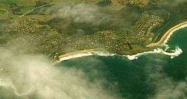 Aerial view: Kiama Downs to the left and centre, and Minnamurra to the right. | |||||||||||||
| Coordinates | 34°38.5′S 150°51.0′E / 34.6417°S 150.8500°ECoordinates: 34°38.5′S 150°51.0′E / 34.6417°S 150.8500°E | ||||||||||||
| Population | 5,209 (2006)[1] | ||||||||||||
| Postcode(s) | 2533 | ||||||||||||
| LGA(s) | Municipality of Kiama | ||||||||||||
| State electorate(s) | Kiama | ||||||||||||
| Federal Division(s) | Gilmore | ||||||||||||
| |||||||||||||
Kiama Downs is a coastal suburb of the town Kiama in the Illawarra region south of Sydney, Australia. Renowned for its picturesque beaches and seaside views, it is about 3 km (2 mi) north of Kiama and is bordered by the Minnamurra River to the northwest and Jones Beach to the east.
There is a bakery, cafe, pharmacy, supermarket, take away store and small general practice on Johnson Street.
The western part of the suburb, west of Riverside Drive, is informally known as Gainsborough.
Kiama Downs does not have a school or a railway station. The nearest public primary school is Minnamurra Public School and the nearest public high school is Kiama High School. The nearest railway stations are Minnamurra and Bombo.
References
- ↑ Australian Bureau of Statistics (25 October 2007). "Kiama Downs (State Suburb)". 2006 Census QuickStats. Retrieved 2010-01-08.
This article is issued from Wikipedia - version of the 7/2/2016. The text is available under the Creative Commons Attribution/Share Alike but additional terms may apply for the media files.