Illawarra escarpment
| Illawarra | |
|---|---|
|
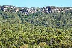
Lookout from the Illawarra Escarpment above Wombarra over the northern Illawarra plain viewing Austinmer, Thirroul, Bulli, Wollongong up to Port Kembla in the far distance. | |
| Highest point | |
| Peak | Bells Hill, New South Wales |
| Elevation | 803 m (2,635 ft) |
| Coordinates | 34°37′S 150°36′E / 34.617°S 150.600°E [1] |
| Dimensions | |
| Length | 92 km (57 mi) NNE [2] |
| Geography | |
| Country | Australia |
| State | New South Wales |
| Region | Illawarra |
| Range coordinates | 34°20′S 150°50′E / 34.33°S 150.83°ECoordinates: 34°20′S 150°50′E / 34.33°S 150.83°E [2] |
| Geology | |
| Orogeny | Sydney Basin |
| Age of rock | Tertiary |

The Illawarra escarpment, or officially the Illawarra Range,[2] is the fold-created cliffs and plateau-eroded outcrop mountain range west of the Illawarra coastal plain south of Sydney, in the state of New South Wales, Australia. The range encloses the Illawarra region which stretches from Stanwell Park in the north to Kiama, Gerringong and the Shoalhaven River in the south.
Bells Hill, west of Knights Hill, is the highest point in the range at 803 metres (2,635 ft) AHD on the range's plateau; with a number of other peaks on the escarpment ranging from 300 metres (980 ft) to a maximum of 768 metres (2,520 ft) at Mount Murray southwest of Dapto.
History


The escarpment or scarp was created between 225 to 280 million years ago and since eroded by creeks to its present height around 30 million years ago. Most of it is sandstone, with many Hawkesbury sandstone boulders and ledges visible in addition to the actual cliffs. Its maximum heights are reached in the south, west of Albion Park at Knights Hill, 709 metres (2,326 ft), and Mount Murray, 768 metres (2,520 ft). This forms the eastern edge of the Southern Highlands plateau, uplifted along with the Blue Mountains around 70 million years ago.
Many of the towns on the coastal plain adjacent to the escarpment were first founded to harvest the cedar trees on the slopes of the escarpment or the coal seams beneath it. With the original logging industry of the area came the need for passes over the escarpment, creating such ones as Rixons Pass, Bulli Pass, O'Briens Road and Macquarie Pass. The city of Wollongong is the central city in the Illawarra.
Fauna
The escarpment contains a wide variety of native flora and fauna and is a haven for many forms of wildlife. It is known for the Illawarra Flame Tree with its bright foliage, as well as rare surviving red cedar trees that haven't been logged. On Saddleback Mountain and at Minnamurra Rainforest and other places there are remnant localities of rainforest bushland, as well as, to the north, dry sclerophyll forests. The southern typical bush meets the northern at Mount Kembla, creating a unique effect. Many bird and animal species thrive here and the escarpment also contains many historic sites such as mine entrances and passes.
Geography
Geographically it stretches from the white cliffs of the Royal National Park and its northern hilly ridge formations like Bulgo and Otford Hills and Stony Batter, Undola Ridge and Bald Hill, south past the Otford Valley to the west and around an eroded valley containing Stanwell Park, then it goes south, featuring cliffs and running close to the coastal headlands, approximately 300 metres (980 ft) above sea level at Scarborough to the turn at Sublime Point at 415 metres (1,362 ft) near Thirroul, south to Brokers Nose at 440 metres (1,440 ft) promontory, south to Mount Keira, which juts out from the main cliffs, south to a similar eroded sandstone outcrop, Mount Kembla at 534 metres (1,752 ft), then southwest along the Dapto scarp cliffs including Mount Bong Bong to the turn inland at Macquarie Pass, then back east to the promontory at Knights Hill at 709 metres (2,326 ft), south including Jamberoo Mountain and east to Noorinan Mountain promontory at Barren Grounds Plateau, then along a ridge to its southern tip, Saddleback Mountain.
The Cambewarra Range is considered a separate, yet related, geological formation that continues around the Noorinan promontory and continues around Kangaroo Valley.
It ranges in height from the tops of Bald Hill and Stony Batter around 300 metres (980 ft) above sea level, to 440 metres (1,440 ft) at Brokers Nose, generally above 350 metres (1,150 ft) high south of Mount Ousley Road (between Keira and Brokers Nose) it reaches 464 metres (1,522 ft) at Mount Keira, 464 metres (1,522 ft) at Mount Warra, 469 metres (1,539 ft) at Mount Brisbane, 531 metres (1,742 ft) at Mount Burelli, 512 metres (1,680 ft) at Kembla West, 534 metres (1,752 ft) at Mount Kembla, 564 metres (1,850 ft) at Wanyambilli Hill on the plateau to the west and 709 metres (2,326 ft) at Knights Hill, just over 663 metres (2,175 ft) at Noorinan Mountain and about 600 metres (2,000 ft) at Saddleback Mountain.
It is mostly of hard sandstone, with outcrops like Mount Keira and Mount Kembla rising above 450 metres (1,480 ft). There are many tracks to the top of such summits including the southern tip of the escarpment, Saddleback Mountain and Noorinan Mountain promontory. The flora ranges from northern and southern eucalypts and at Mount Kembla fuses, providing an interesting phenomena. The range has much history, including Hoddles Track which used to go to Bowral from Kiama.

To the north the range is mostly a coastal ridge east of Otford, becoming a cliff at Mount Mitchell, and continuing to include an eroded cliff at its top until Bulli Pass where it becomes rounded, forming Woonona Mountain, until Brokers Nose where the cliff reappears, before appearing again on the edge of Mount Keira and Warra, disappearing until west of Dapto where it forms the famous southern escarpment and curves in for Macquarie Pass National Park and Mount Murray at 768 metres (2,520 ft) before turning into Knights Hill at 709 metres (2,326 ft) and then forming Noorinan promontory, its summit at 663 metres (2,175 ft), and Saddleback Mountains.
Passes
There are several passes over the escarpment:
- At Bald Hill, where Lawrence Hargrave Drive descends into Stanwell Park;
- At Bulli, where the road goes down from Bulli Pass Lookout near Sublime Point Lookout, around a tight bend and then down into the town of Thirroul;
- At Rixons Pass where the road descends around several tight curves just north of Brokers Nose promontory, and is now a management trail used for mountain biking;
- At Mount Ousley Road, now a freeway, the main route is used for the majority of vehicular traffic and is designed to accommodate slower-moving trucks and buses;
- At Mount Keira Road, built by convict labour and still, in a slightly changed form, used today;
- At O'Briens Road, now partially used by Harry Graham Drive, the Mount Nebo section now a walking and riding track;
- At Cordeaux Road, Mount Kembla, which climbs around Kembla West at 512 metres (1,680 ft), to reach the catchment area to the west;
- At Macquarie Pass, south of Dapto, protected by a national park; and
- At Jamberoo Mountain Road pass, east of the mountain of that name, which climbs through a winding pattern to the summit and along the escarpment to Knights Hill and beyond west.
- West of Albion Park is Callula Pass, passes below Knights Hill and descends to Yellow Rock west of Albion Park, a proposed alternate route to Macquarie Pass, Not used since WWII. Still walk-able
- Between Dapto and Albion Park, Johnsons Spur which has not been used since the establishment of Macquarie Pass. Was the main access route from the Illawarra to the Southern Tablelands, not only walk-able
Saddleback Mountain Road only reaches the summit after a short, steep, turnoff, but was once part of Hoddles Track, which is now only in existence in a small ridge track from the summit but used to extend west to the Southern Highlands.
Protected areas
Numerable areas are protected as part of the Illawarra Escarpment State Conservation Area or as state forests such as Kembla State Forest southwest of Wollongong. Much is however private property or owned by mining companies like BHP. Well known and popular lookouts such as at Mount Keira and Bald Hill are reserves or parks, the Mount Keira Summit Park is an annexe of the Wollongong Botanic Garden like Puckeys Estate Reserve on the plain.
Walking tracks
There are many walking tracks and lookouts with views of the surrounding countryside to the south, or suburbs to the north and coastal villages to the far north, and bushland and suburbs to the north. There are several well-known lookouts, such as Bald Hill, Bulli Pass, Sublime Point and Mount Keira, as well as lesser known tracks with views such as Hoddles Track west of Saddleback Mountain. Some tracks have gone into disrepair such as the Wodi Wodi track at Stanwell Park, but some such as the Mount Keira Ring Track have been upgraded. Weed infestation is a problem, with many areas invaded by lantana and other invasive weeds.
See also
References
- ↑ "Bells Hill". Geographical Names Register (GNR) of NSW. Geographical Names Board of New South Wales. Retrieved 29 December 2013.
- 1 2 3 "Illawarra Range". Geographical Names Register (GNR) of NSW. Geographical Names Board of New South Wales. Retrieved 29 December 2013.
- R.W. Young (1980-1984)"The Illawarra Escarpment", Wollongong Studies in Geography No. 2 Department of Geography, University of Wollongong
External links
| Wikimedia Commons has media related to Illawarra escarpment. |
- "Illawarra Coal" - An unofficial history of coal mining in the Illawarra
- Northern Illawarra Community Web Portal
- Ross, Graham (20 January 2013). "Exploring the Illawarra Escarpment". Off Track (Interview). Interview with Steve Allen. Australia: Australian Broadcasting Corporation – via Radio National.