Killington, Vermont
| Killington, Vermont | |
|---|---|
| Town | |
|
Killington town logo | |
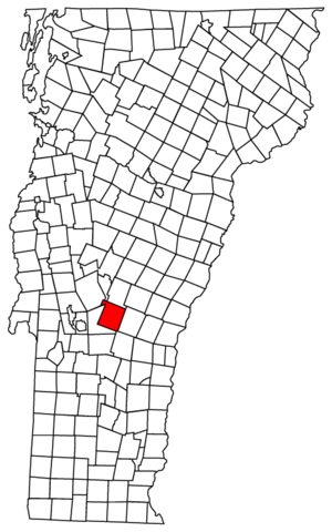 Killington, Vermont | |
| Coordinates: 43°39′53″N 72°47′36″W / 43.66472°N 72.79333°WCoordinates: 43°39′53″N 72°47′36″W / 43.66472°N 72.79333°W | |
| Country | United States |
| State | Vermont |
| County | Rutland |
| Area | |
| • Total | 46.9 sq mi (121.4 km2) |
| • Land | 46.6 sq mi (120.8 km2) |
| • Water | 0.2 sq mi (0.6 km2) |
| Elevation | 1,841 ft (561 m) |
| Population (2010) | |
| • Total | 811 |
| • Density | 17/sq mi (6.7/km2) |
| Time zone | Eastern (EST) (UTC-5) |
| • Summer (DST) | EDT (UTC-4) |
| ZIP code | 05751 |
| Area code(s) | 802 |
| FIPS code | 50-37685[1] |
| GNIS feature ID | 1462208[2] |
| Website | http://www.killingtontown.com/ |
Killington is a town in Rutland County, Vermont, United States. The population was 811 at the 2010 census. Killington Ski Resort and numerous vacation lodges are located here. The town was previously named Sherburne, but was renamed to its original name, "Killington," in 1999.
History
The town of Killington was chartered on July 7, 1761 by a New Hampshire grant. In 1800, it was renamed Sherburne[3] after landholder Colonel Benjamin Sherburne.[4] The town voted to revert to its original name of Killington on March 2, 1999; which was approved by the Vermont General Assembly, and became effective July 1, 1999.[5]
The 2007 town meeting considered a proposal to impose a three cent surcharge on every dollar of property tax revenue. The proceeds would have been used to fund a town economic development group. The surcharge was not approved by the voters.[6]
Killington was one of thirteen Vermont towns isolated by flooding caused by Hurricane Irene on August 28, 2011. Killington was cut off for 19 days.[7]
Secession referendums
Killington's voters have twice voted to secede from Vermont and join the state of New Hampshire, 25 miles (40 km) to the east. The movement stems from what some residents perceive as an inequity in taxes sent to the state of Vermont, for services received. The votes are largely symbolic, as secession would require the agreement of both states' legislatures.
Geography
According to the United States Census Bureau, the town has a total area of 46.9 square miles (121 km2), of which 46.6 square miles (121 km2) is land and 0.2 square miles (0.52 km2), or 0.47%, is water. The Ottauquechee River has its headwaters in the town.[8]
Demographics
| Historical population | |||
|---|---|---|---|
| Census | Pop. | %± | |
| 1790 | 32 | — | |
| 1800 | 90 | 181.3% | |
| 1810 | 116 | 28.9% | |
| 1820 | 154 | 32.8% | |
| 1830 | 452 | 193.5% | |
| 1840 | 498 | 10.2% | |
| 1850 | 578 | 16.1% | |
| 1860 | 525 | −9.2% | |
| 1870 | 462 | −12.0% | |
| 1880 | 450 | −2.6% | |
| 1890 | 451 | 0.2% | |
| 1900 | 402 | −10.9% | |
| 1910 | 409 | 1.7% | |
| 1920 | 336 | −17.8% | |
| 1930 | 298 | −11.3% | |
| 1940 | 266 | −10.7% | |
| 1950 | 283 | 6.4% | |
| 1960 | 266 | −6.0% | |
| 1970 | 558 | 109.8% | |
| 1980 | 891 | 59.7% | |
| 1990 | 738 | −17.2% | |
| 2000 | 1,095 | 48.4% | |
| 2010 | 811 | −25.9% | |
| Est. 2014 | 795 | [9] | −2.0% |
| U.S. Decennial Census[10] | |||
As of the census[1] of 2000, there were 1,095 people, 500 households, and 282 families residing in the town.[11] The population density was 23.5 people per square mile (9.1/km2). There were 2,528 housing units at an average density of 54.2 per square mile (20.9/km2). The racial makeup of the town was 97.63% White, 0.37% African American, 0.09% Native American, 0.64% Asian, and 1.28% from two or more races. Hispanic or Latino of any race were 0.91% of the population.
There were 500 households, out of which 25.2% had children under the age of 18 living with them; 48.6% were married couples living together; 5.6% had a female householder with no husband present; and 43.6% were non-families. 34.2% of all households were made up of individuals, and 5.8% had someone living alone who was 65 years of age or older. The average household size was 2.19, and the average family size was 2.80.
In the town the population was spread out with 20.5% under the age of 18, 5.8% from 18 to 24, 29.4% from 25 to 44, 33.3% from 45 to 64, and 11.1% who were 65 years of age or older. The median age was 42 years. For every 100 females there were 115.1 males. For every 100 females age 18 and over, there were 116.7 males.
The median income for a household in the town was $47,500, and the median income for a family was $60,125. Males had a median income of $36,618 versus $27,368 for females. The per capita income for the town was $32,066. About 6.4% of families and 7.0% of the population were below the poverty line, including 12.6% of those under age 18 and 1.7% of those age 65 or over.
Business
One of the area's major business ventures can be found in the Killington Ski Resort, the largest ski area in the Eastern U.S.
References
- 1 2 "American FactFinder". United States Census Bureau. Retrieved 2008-01-31.
- ↑ "US Board on Geographic Names". United States Geological Survey. 2007-10-25. Retrieved 2008-01-31.
- ↑ Virtual Vermont.com accessed March 8, 2008
- ↑ "Profile for Sherburne, Vermont". ePodunk. Retrieved 2010-05-10.
- ↑ 2000 Docs; Vermont Government, online; accessed .
- ↑ Aid?; Rutland Herald; accessed .
- ↑ Floodwaters from Storm Isolate 13 Vermont Towns; article; The New York Times online; accessed .
- ↑ DeLorme (1996); "Vermont Atlas & Gazetteer;" Yarmouth, Maine; DeLorme; ISBN 0-89933-016-9.
- ↑ "Annual Estimates of the Resident Population for Incorporated Places: April 1, 2010 to July 1, 2014". Retrieved June 4, 2015.
- ↑ "U.S. Decennial Census". United States Census Bureau. Retrieved May 16, 2015.
- ↑ "Profile of General Population and Housing Characteristics: 2010 Demographic Profile Data (DP-1): Killington town, Vermont". U.S. Census Bureau, American Factfinder. Retrieved November 3, 2011.
External links
Municipalities and communities of Rutland County, Vermont, United States | ||
|---|---|---|
| City | 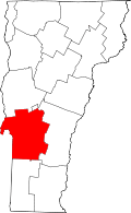 | |
| Towns | ||
| Village | ||
| CDPs | ||
| Other communities | ||