Kilmaleery
| Kilmaleery Cill Mhaoilfhithrigh | |
|---|---|
| Parish | |
|
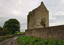
Clenagh Castle | |
 Kilmaleery | |
| Coordinates: 52°44′00″N 8°56′23″W / 52.733305°N 8.939639°WCoordinates: 52°44′00″N 8°56′23″W / 52.733305°N 8.939639°W | |
| Country | Ireland |
| Province | Munster |
| County | County Clare |
| Time zone | WET (UTC+0) |
| • Summer (DST) | IST (WEST) (UTC-1) |
Kilmaleery (Irish: Cill Mhaoilfhithrigh[1]) is a civil parish in County Clare, Ireland. It is part of the Catholic parish of Newmarket-on-Fergus.
Location
The parish lies on the western border of the barony of Bunratty Lower. It is 1.5 miles (2.4 km) southwest of Newmarket, County Clare. The parish is 2.75 by 1.75 miles (4.43 by 2.82 km) and covers 2,266 acres (917 ha). It forms part of the eastern seaboard of the River Fergus estuary, and generally is good farmland.[2]
Antiquities and history
The name of the parish implies an ecclesiastical origin, but nothing is known of the patron saint. As of 1897 the church was very dilapidated. There is one holy well, Tobar Mailiaraidh, and a lios or small ringfort called Knockadoon.[3] As of 1837 the parish was part of the Catholic union of Newmarket, and had a chapel at Carrigeary.[4] In 1841 the population was 737 in 104 houses.[2]
There were three castle, very well preserved in 1897. In 1580 Urlan was inhabited by Murtagh MacClancy and Bodavoher was the property of Donagh MacClancy. Clenagh is not mentioned in list of the Castles of Thomond for that year.[3] Clenagh Castle, still almost intact, was a high square tower that was once the residence of the MacMahons.[4]
Townlands
The townlands are Ballinooskny, Ballymacnevin, Breckinish, Carrow, Carrowbane, Clenagh, Islandmacnevin, Kilmaleery, Urlan Beg, Urlan More and Ing.[5]
References
Citations
Sources
- "Cill Mhaoilfhithrigh". Placenames Database of Ireland. Retrieved 2014-04-07.
- Frost, James (1897). "Tradraighe. Kilmaleery Parish". The History and Topography of the County of Clare. Retrieved 2014-04-07.
- Lewis, Samuel (1837). "Kilmaleery". County Clare: A History and Topography. Retrieved 2014-04-07.
- "Map of Kilmaleery Parish showing Townlands". Clare County Library. Retrieved 2014-04-07.
- "Kilmaleery". Parliamentary Gazeteer of Ireland 1845. Retrieved 2014-04-07.