Kingman, Alberta
| Kingman | |
|---|---|
| Hamlet | |
|
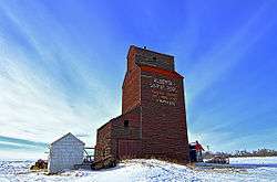
Former Kingman Alberta Wheat Pool elevator. Now located on a private farm south of Kingman. | |
 Location of Kingman in Alberta | |
| Coordinates: 53°12′48″N 112°44′58″W / 53.2133°N 112.7494°WCoordinates: 53°12′48″N 112°44′58″W / 53.2133°N 112.7494°W | |
| Country |
|
| Province |
|
| Census division | No. 10 |
| Municipal district | Camrose County |
| Established | 1909 |
| Government | |
| • Type | Unincorporated |
| • Governing body | Camrose County Council |
| Area[1] | |
| • Total | 0.41 km2 (0.16 sq mi) |
| Elevation | 740 m (2,430 ft) |
| Population (2011)[1] | |
| • Total | 90 |
| • Density | 220/km2 (570/sq mi) |
| • Dwellings | 45 |
| Time zone | MST (UTC-7) |
Kingman is a hamlet in central Alberta, Canada within Camrose County.[2] It is located approximately 27 kilometres (17 mi) north of Camrose and has an elevation of 740 metres (2,430 ft).
The hamlet is located in census division No. 10 and in the federal riding of Crowfoot.
As proclaimed on the entry signs for the hamlet, Kingman is known as the Lutefisk capital of Alberta.
Demographics
As a designated place in the 2011 Census, Kingman had a population of 90 living in 40 of its 45 total dwellings, a 3.4% change from its 2006 population of 87. With a land area of 0.41 km2 (0.16 sq mi), it had a population density of 220/km2 (570/sq mi) in 2011.[1]
The population of Kingman according to Camrose County's 2008 municipal census is 79.[3]
As of 2006, Kingman had a total population of 87 living in 34 dwellings. With a land area of 0.41 km2 (0.16 sq mi), it has a population density of 209.7/km2 (543/sq mi).[4]
See also
References
- 1 2 3 "Population and dwelling counts, for Canada, provinces and territories, and designated places, 2011 and 2006 censuses (Alberta)". Statistics Canada. 2012-02-08. Retrieved 2012-04-07.
- ↑ Alberta Municipal Affairs (2010-04-01). "Specialized and Rural Municipalities and Their Communities" (PDF). Retrieved 2010-06-20.
- ↑ Camrose County (2010-07-25). "Camrose County Census 2008" (PDF). Retrieved 2010-10-03.
- ↑ Statistics Canada (2007). "Population and dwelling counts, for Canada, provinces and territories, and designated places, 2006 and 2001 censuses". Retrieved 2010-01-31.
External links
 |
Miquelon Lake Provincial Park | Tofield | Beaverhill Lake |  |
| Hay Lakes | |
Ryley | ||
| ||||
| | ||||
| Armena | Camrose | Round Hill |
