Kingsland, Texas
| Kingsland, Texas | |
|---|---|
| CDP | |
|
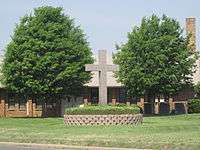
As part of the Antlers Hotel, the Grand Central Cafe Restaurant and Club Car Bar in Kingsland is built in the style of Queen Anne architecture. Before the structure was moved from Round Rock, Texas to Kingsland, it had been used as part of the set for the 1974 film The Texas Chain Saw Massacre. For additional information see: Texas Chainsaw House. | |
| Motto: "Where Any Time Is Lake Time..."[1] | |
 Location of Kingsland, Texas | |
 | |
| Coordinates: 30°40′2″N 98°26′41″W / 30.66722°N 98.44472°WCoordinates: 30°40′2″N 98°26′41″W / 30.66722°N 98.44472°W | |
| Country | United States |
| State | Texas |
| County | Llano |
| Area | |
| • Total | 9.8 sq mi (25.3 km2) |
| • Land | 9.0 sq mi (23.3 km2) |
| • Water | 0.8 sq mi (2.0 km2) |
| Elevation | 837 ft (255 m) |
| Population (2000) | |
| • Total | 4,584 |
| • Density | 509.4/sq mi (196.7/km2) |
| Time zone | Central (CST) (UTC-6) |
| • Summer (DST) | CDT (UTC-5) |
| ZIP code | 78639 |
| Area code(s) | 325 |
| FIPS code | 48-39304[2] |
| GNIS feature ID | 1360680[3] |
| Website | http://www.kingslandchamber.org/ |


Kingsland is a census-designated place (CDP) in Llano County, Texas, United States. The population was 6,030 at the 2010 census. Texas Ranch to Market Road 1431 runs through the community.
Geography
Kingsland is located at 30°40′02″N 98°26′41″W / 30.667102°N 98.444627°W (30.667102, -98.444627).[4] The town is at the confluence of the Colorado and the Llano rivers, which combine to form Lake Lyndon B. Johnson.
According to the United States Census Bureau, the CDP has a total area of 9.8 sq mi (25 km2), of which, 9.0 sq mi (23 km2) of it is land and 0.8 square miles (2.1 km2) of it (7.88%) is covered by water.
Demographics
As of the census[2] of 2000, 4,584 people, 2,103 households, and 1,343 families resided in the CDP. The population density was 509.4 people per square mile (196.7/km2). There were 2,803 housing units at an average density of 311.5/sq mi (120.2/km2). The racial makeup of the CDP was 95.66% White, 0.13% African American, 0.31% Native American, 0.52% Asian, 0.02% Pacific Islander, 2.31% from other races, and 1.05% from two or more races. Hispanics or Latinos of any race were 5.89% of the population.
Of the 2,103 households, 18.2% had children under the age of 18 living with them, 55.3% were married couples living together, 6.0% had a female householder with no husband present, and 36.1% were not families. About 32.4% of all households were made up of individuals, and 20.8% had someone living alone who was 65 years of age or older. The average household size was 2.13 and the average family size was 2.64.
In the CDP, the population was distributed as 17.4% under the age of 18, 5.3% from 18 to 24, 19.6% from 25 to 44, 24.9% from 45 to 64, and 32.9% who were 65 years of age or older. The median age was 51 years. For every 100 females, there were 91.0 males. For every 100 females age 18 and over, there were 87.4 males.
The median income for a household in the CDP was $29,615, and for a family was $33,679. Males had a median income of $27,264 versus $19,255 for females. The per capita income for the CDP was $18,220. About 6.8% of families and 12.2% of the population were below the poverty line, including 21.5% of those under age 18 and 9.6% of those age 65 or over.
Arts and culture
Among Kingsland's notable places is the 1901 Victorian-style Antlers Hotel, a railroad resort in Kingsland that fell into disrepair in the early 1900s, but was purchased and restored in the 1990s and reopened as the Antlers Hotel, with the Grand Central Cafe Restaurant in Queen Anne architecture and an historic railroad district.[5] The house where The Texas Chain Saw Massacre was filmed [6] (the Texas Chainsaw House) is located here and has been restored as a restaurant. It was moved here from Round Rock, Texas, from the site of what is now the La Frontera development in Williamson County in the 1998 by the owners of the hotel, and completely renovated to become an on-site restaurant.[7]
Also a favorite location is "The Slab", where the road traverses the clear Llano River as it crosses over granite slabs and boulders. Both residents and tourists come to the slab to bask in the warm sun and swim or wade in the clear water running over the granite.
Education
Kingsland is served by the Llano Independent School District, and is the location of Packsaddle Elementary School. Jr. High and High-school aged youth are bussed to Llano Jr. High and Llano High School, 18 miles away in Llano, TX.
See also
References
- ↑ "Kingsland Chamber of Commerce". Kingsland Chamber of Commerce. Retrieved October 3, 2012.
- 1 2 "American FactFinder". United States Census Bureau. Retrieved 2008-01-31.
- ↑ "US Board on Geographic Names". United States Geological Survey. 2007-10-25. Retrieved 2008-01-31.
- ↑ "US Gazetteer files: 2010, 2000, and 1990". United States Census Bureau. 2011-02-12. Retrieved 2011-04-23.
- ↑ Mike Cox (July 13, 2006). "TexasEscapes: The Antlers". TexasEscapes.com. Retrieved 3 February 2011.
- ↑ Tim Hardin. "Texas Chainsaw Massacre (FAQs)". Retrieved July 23, 2010.
- ↑ Pack, MM (2003-10-23). "The Killing Fields: A culinary history of 'The Texas Chainsaw Massacre' farmhouse". The Austin Chronicle. Retrieved 2011-02-02.
External links
| Wikimedia Commons has media related to Kingsland, Texas. |
- Kingsland from the Handbook of Texas Online
- Kingsland Current newspaper
- Kingsland Masonic Lodge #1424 Newsletter
- Kingsland Chamber of Commerce
- City-Data.com
Municipalities and communities of Llano County, Texas, United States | ||
|---|---|---|
| Cities | 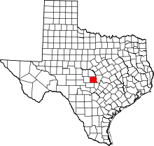 | |
| CDPs |
| |
| Other unincorporated communities | ||
| Ghost towns | ||
| Footnotes | ‡This populated place also has portions in an adjacent county or counties | |