Kinniya
| Kinniya | |
|---|---|
| Town | |
|
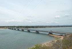
Bridge at Kinniya, Trincomalee District | |
 Kinniya | |
| Coordinates: 8°29′0″N 81°11′0″E / 8.48333°N 81.18333°E | |
| Country | Sri Lanka |
| Province | Eastern |
| District | Trincomalee |
| DS Division | Kinniya |
| Government | |
| • Type | Urban Council |
| • Special Commissioner | Secretary (UPFA) |
Kinniya (Tamil: கிண்ணியா, Sinhalese: කින්නියා) is a second town located in Trincomalee District of the Eastern province of Sri Lanka. It is located about 20 km from the town of Trincomalee and 240 km from the national capital Colombo.
With over 85,000 [1] inhabitants, 97% of Kinniya residents are ethnic Muslims with the remaining being Tamils.
It has marked as a first town surpassed with over 70,000 muslim inhabitants in sri lanka and also have three parliamentarian within kinniya.
Located in Sri Lanka's dry zone, the Kinniya region often experiences hot and dry weather with very little precipitation. Sri Lanka's longest bridge is situated in this town, which is a tourist attraction in the area.
Being located on the Trincomalee Harbor, Kinniya was badly devastated by the massive Tsunami that resulted from the 2004 Indian Ocean earthquake.
History Of Kinniya
Kinniya has an ancient footages of over 500 years history. A 400 years old Grand masjid in kinniya has reconstructed in 2002 by the Saudi Arabian government. The more Inhabitants from kinniya were the emigrand people from Morocco, Java, Pakistan and Afghanistan. Its name "Kinniya" defines the kinni tree which was the identity of the people of kinniya once upon a time.
Education
Kinniya has well educated structures from all streams such as, Medicine, Law, Engineering and academic staffs. Around 50 government schools are here. Government, private schools and higher education centers also situated for the education purposes. A few years ago, Due to the ethnic conflicts it had been suffered in education as unable to go to any places for higher studies.
See also
- Kinniya Urban Council
- Nilaveli
- Thiriyai
- sinna kinniya
References
- ↑ "City Population". www.citypopulation.de. Retrieved 2008-12-30.
External links
| ||
Coordinates: 8°29′N 81°11′E / 8.483°N 81.183°E