Kirrawee, New South Wales
| Kirrawee Sydney, New South Wales | |||||||||||||
|---|---|---|---|---|---|---|---|---|---|---|---|---|---|
 Oak Road, Kirrawee | |||||||||||||
| Coordinates | 34°02′05″S 151°04′16″E / 34.034722°S 151.071111°ECoordinates: 34°02′05″S 151°04′16″E / 34.034722°S 151.071111°E | ||||||||||||
| Population | 10,098 (2011 census)[1] | ||||||||||||
| • Density | 2,404/km2 (6,230/sq mi) | ||||||||||||
| Established | 1939 | ||||||||||||
| Postcode(s) | 2232 | ||||||||||||
| Area | 4.2 km2 (1.6 sq mi) | ||||||||||||
| Location | 25 km (16 mi) south of Sydney CBD | ||||||||||||
| LGA(s) | Sutherland Shire | ||||||||||||
| State electorate(s) | |||||||||||||
| Federal Division(s) | Hughes | ||||||||||||
| |||||||||||||


Kirrawee is a suburb in southern Sydney, in the state of New South Wales, Australia. Kirrawee is located 25 kilometres south of the Sydney central business district in the Sutherland Shire. Kirrawee lies between Sutherland, to the west, and Gymea and Grays Point, to the east. Kirrawee's southern border is formed by The Royal National Park, while Kareela and Jannali form the northern border.
Kirrawee is split between commercial and residential areas. Approximately 50% of the area to the north of the train line is occupied by commercial and industrial properties, while almost all of the area south of the train line is residential. South Kirrawee, which extends from the train line in the north to the Royal National Park in the south, has many houses on quiet roads with beautiful bush outlooks. North Kirrawee is predominantly a commercial/industrial zone containing small to medium-sized factories housing local businesses. It is also home to a number of petrol stations, car dealerships and a fast food chain outlet. However, the most northerly and western sections of this part of Kirrawee are residential, with some parts also with bush outlooks.
History
The Sutherland Shire Council website suggests two possible origins for the name, "Kirrawee".[2] The first possibility is that it derives from an Aboriginal word meaning 'lengthy'; the second is that it derives from a Dharawal word, "gi(a)rrawee(i)" (alternative spelling "garrawi"), which means 'place of white cockatoos' or 'sulphur-crested cockatoos'.[2][3] The current signage erected by the Council uses 'place of white cockatoos' as the accepted meaning for the suburb name.[4] The name was adopted in 1939 with the opening of the Sutherland-Cronulla railway line.[2] A postal receiving office in the locality was known as 'Bladesville'. It operated from the home of Mrs Louisa Blade, was opened in 1909 and closed in 1915 when a letter delivery service commenced from the post office at Sutherland.
Kirrawee, and all of southern Sydney, was inhabited by the Dharawal people for up to 8,000 years prior to European settlement.
Early non-indigenous development of the area was connected to the non-indigenous development of nearby Sutherland. It was not until the 1950s that Kirrawee became heavily settled, with many families looking to resettle after World War II. Some street names in Kirrawee commemorate colonial figures connected with the Rum Rebellion: Bligh Street and Putland Close were named after Governor William Bligh, and his daughter, Mary Putland, respectively;[2] Johnston Avenue was named after George Bain Johnston, a First Fleet lieutenant who arrested Governor Bligh;[2] Kemp Avenue was named after Anthony Fenn Kemp, a captain in charge of government stores who was also involved in Bligh's arrest.[2]
Commercial area
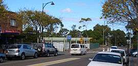
Kirrawee has a small shopping village on Oak Road, adjacent to the Kirrawee train station. It consists of a number of food outlets, newsagent, law firm, accountant, fruit shop and bike shop, among others. The train station and shopping village are located in the geographical centre of the suburb and are serviced by a 150 space carpark. A number of painted murals located around the shopping village and train station are an interesting feature in the suburb.
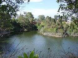
Kirrawee Brick Pit
Kirrawee's long-disused former brick pit is a 4.5ha site just north of the main shopping village, and its future has been the source of much debate by local residents, politicians, potential developers, and media in the locality.
Original development
Used for industrial purposes between 1912 and 1979, the land was owned by various brick manufacturers, including Sutherland Brick Co, Refractory Bricks, and Punchbowl Brick and Tile Co. Sydney Water Board acquired the land in 1974 for water-storage purposes, but instead it became an equipment storage facility.
Lagoon & wildlife habitat
Until recent development of the site, a deep pit covered approximately 50 - 60% of the total brick pit site and measured about 230 metres long by about 80 metres wide and was about 16 metres deep. The entire site was enclosed by a cyclone fence, preventing public access. Over many years, the pit had become half-filled with water, making a natural lagoon. The remainder of the site was covered with overgrown trees and plants and had become home to many diverse species of animals,[5] most notably bird life, which could be seen nesting and swimming on and around the water.[5]
Re-development and controversy
This site has been the subject of much controversy over recent years.
When it was evident Sydney Water had no further use for the site, the State Government proposed to sell the site to developers for use as a mix of apartments, business units, and a small park. Kirrawee Chamber of Commerce and a residents' group instead proposed that the site be turned into a performing arts centre and large park.
In 2001, a 20-month program commenced to consult with the community about the future use of the site. This project was a joint initiative between the local council, the Department of Infrastructure, Planning and Natural Resources (DIPNR), Sydney Water (the then-owner of the site), and the local community. The Local Environment Plan (LEP) produced a master plan for the Kirrawee shopping village and brick pit which involved rezoning the site to a mix of commercial, residential, and 20% open public space.
In April 2005, after the election of a new councillor, 45 amendments were passed with regards to the LEP. These amendments changed the zoning to make the Princes Highway frontage commercial and the remainder "special uses". It was specifically noted that "...educational establishments are a permissible use in both zones".
Sutherland Shire Council moved to change the plan, but NSW state government Planning Minister, Frank Sartor cemented the original proposal in a rewritten local environment plan.
In July 2007, a development group called Kirrawee Centre Pty Ltd, with directors including architect, George Revay, and brothers Stanley and John Roth, purchased the site from Sydney Water for $22.5million.
The State Government had previously said the buyer would have to develop it in accordance with a comprehensive master plan, which includes a mix of multi-storey apartments, business units and a one-hectare public park.[6]
In May 2008 a new development application was proposed for the site including a shopping centre with 2 supermarkets and 63 apartments.
The development tick-tacked between council and the developer and eventually a far more commercially-based development proposal was lodged with the Land and Environment Court of NSW and heard over February, April, June and July 2009, with a judgement made on 7 August 2009.
In the case of Restifa Pty Ltd v Sutherland Shire Council & Ors [2009] NSWLEC 1267, the developer appealed against the Council’s refusal of the development Master Plan for the site and of construction of Stage 1 for a mixed retail, commercial, residential development with a child care centre, basement car parking and open space recreation area. In the judgement, it was pointed out that, during the course of the hearing, there were many amendments and six sets of plans submitted. The retail component of the development was amended from the two supermarkets totalling about 7,000 square metres, with total retail 10,500 square metres, to a proposal of one 4,500 square metres supermarket and total retail of about 8,000 square metres. The development was ultimately rejected.
Most recent development proposals
In July 2010, the current owners, Henroth Investments Pty Ltd, bypassed Sutherland Shire Council, lodging a new development application with the NSW Planning Department for a $220 million, nine-storey development, including nearly 500 residential units, over 13,500 square metres of retail space and 1,378 car spaces.
The current application has 30 percent more units than the proposal refused by the Land and Environment Court in August 2009, which raised a number of concerns including the impact on retailers in Kirrawee and Sutherland, the design of the public open space, and the ecological impact.[7] Local retailer Supabarn was one of many to protest strongly, particularly after the group spent $18 million to develop a supermarket site in nearby Sutherland.[8]
On 28 August 2012 the re-development of Kirrawee Brick Pit was approved.[9][10][11]
Transport
Kirrawee railway station is on the Cronulla line which links Sydney's southern suburbs to the CBD. Kirrawee is approximately 40 minutes by train to the CBD. Kirrawee was one of the last remaining single platform stations in Sydney. Duplication of the train line from Sutherland to Cronulla commenced in May 2006 and was completed in 2010. See Government Website.
Kirrawee has bus services operated by Transdev NSW which run down President Avenue and Waratah Street. Princes Highway services do not stop in Kirrawee.
Schools and churches
Education facilities within Kirrawee include Kirrawee High School and Kirrawee Public School, along with a number of pre-schools and childcare centres. Gymea Technology High School also lies on Kirrawee's outskirts.
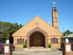
St. Mary, St. Bakhomious and St. Shenouda Coptic Orthodox Church, located in Bath Road, was consecrated in 1996.
Politics
Kirrawee is part of the Sutherland Shire Government Area in Southern Sydney. For local government purposes, the Sutherland Shire is split into 5 wards, A through to E. These wards are reviewed every 4 years. Kirrawee is split between Ward B and Ward C by the Princes Highway which runs east to west through the centre of the suburb.
In Federal parliament, Kirrawee is again split over 2 electorates, Hughes and Cook. All of Kirrawee, aside from a couple of streets, are within the Division of Cook . Both seats are presently held by the Liberal Party (2006).
At state level, Kirrawee is located within the seat of Miranda, which is held by the Australian Labor Party (2013)
References
- ↑ Australian Bureau of Statistics (31 October 2012). "Kirrawee (State Suburb)". 2011 Census QuickStats. Retrieved 21 April 2015.
- 1 2 3 4 5 6 "Sutherland Shire Council - Origin of Street Names" (PDF). Sutherland Shire Council website resources. 'Origin of Street Names'. Sutherland Shire Council. Retrieved 26 January 2016.
- ↑ Bursill, Les (et al). "Dharawal: The Story of the Dharawal People of Southern Sydney." (PDF). Dharawhal: The Story of the Dharawal Speaking People of Southern Sydney. University of Wollongong. Retrieved 26 January 2016.
- ↑ "'New Suburb Signage Acknowledges Shire's Aboriginal Heritage'". Retrieved 26 January 2016 – via Sutherland Shire Council website.
- 1 2 "'Brick Pit Ecological Disaster' - The St George and Sutherland Shire Leader". 18 September 2013. Retrieved 26 January 2016 – via St George and Sutherland Shire Leader website.
- ↑ trembath, murray (17 Sep 2007). "Kirrawee brickpit sold for $22.5m". Retrieved 7 Sep 2010.
- ↑ Gallasch, Rosita (22 Jul 2010). "Brick pit super-sized". The St George and Sutherland Shire Leader. Retrieved 6 Sep 2010.
- ↑ http://www.dpc.nsw.gov.au/__data/assets/pdf_file/0003/86331/Koundouris_Group.pdf
- ↑ http://www.theleader.com.au/news/local/news/general/kirrawee-brick-pit-development-approved/2655868.aspx
- ↑ http://www.theleader.com.au/news/local/news/general/brick-pit-plan-under-review/2086351.aspx
- ↑ http://www.theleader.com.au/news/local/news/general/brick-pit-plan-has-a-lot-of-issues/1934677.aspx
Footnotes
External links
| Wikimedia Commons has media related to Kirrawee, New South Wales. |