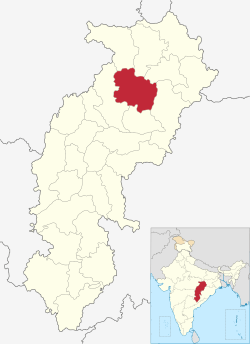
Korba district
| Korba district कोरबा जिला | |
|---|---|
| District of Chhattisgarh | |
 Location of Korba district in Chhattisgarh | |
| Country | India |
| State | Chhattisgarh |
| Administrative division | bilaspur |
| Headquarters | Korba, Chhattisgarh |
| Area | |
| • Total | 6,598 km2 (2,548 sq mi) |
| Population (2011) | |
| • Total | 1,206,640 |
| • Density | 180/km2 (470/sq mi) |
| Demographics | |
| • Literacy | 84.36 per cent |
| Website | Official website |
Korba District is an administrative district of Chhattisgarh state in central India. The city of Korba is the district headquarters.
Geography
The district is situated in the Northern Rocks of the state. Most of the land which has plateau from the Maikal ranges of the Satpura hills, is high and low and open. The biggest area of this open land is spread near Pasan. Hasdeo River has three tributaries: Gajechorai, Tan and Ahiran. On the banks of the rivers are small obstructions, thin forest area and bastties. The area's most important hill is Karela Hill with a height of 3,253 feet (992 m). To the north of Katghora, the slope of the valleys of the Hasdeo and Gage is very less and joins the Surguja District in the north. The Tan and Chorai Rivers joins the River Hasdeo from opposite directions - from the east and the west. Towards the northern banks are the Gurudwari Hill, Janta Hill, Matin and Dhajag Hills.
Korba is known for its coal mines such as Gevra Area (one of the biggest coal mines of Asia), Kusmunda Area and Dipka Area, all located in Korba Coalfield. It also has power plants such as NTPC, CSEB East - West and Balco Aluminium Plant.
Demographics
According to the 2011 census, Korba district has a population of 1,206,563,[1] roughly equal to the nation of Bahrain[2] or the US state of New Hampshire.[3] This gives it a ranking of 395th in India (out of a total of 640).[1] The district has a population density of 183 inhabitants per square kilometre (470/sq mi).[1] Its population growth rate over the decade 2001-2011 was 19.25%.[1] Korba has a sex ratio of 971 females for every 1000 males,[1] and a literacy rate of 73.22%.[1]
References
- 1 2 3 4 5 6 "District Census 2011". Census2011.co.in. 2011. Retrieved 2011-09-30.
- ↑ US Directorate of Intelligence. "Country Comparison: Population". Retrieved 2011-10-01.
Bahrain 1,214,705 July 2011 est.
- ↑ "2010 Resident Population Data". U. S. Census Bureau. Archived from the original on October 19, 2013. Retrieved 2011-09-30.
New Hampshire 1,316,470
External links
- Official website
- Korba government website
- List of places in Korba
- Power production in Korba, from the Chhattisgarh state website
 |
Koriya district | Surguja district |  | |
| Bilaspur district | |
Raigarh district | ||
| ||||
| | ||||
| Janjgir-Champa district |
Coordinates: 22°21′N 82°41′E / 22.350°N 82.683°E
