Mahasamund district
| Mahasamund district महासमुन्द जिला | |
|---|---|
| District of Chhattisgarh | |
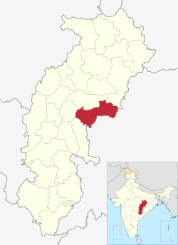 Location of Mahasamund district in Chhattisgarh | |
| Country | India |
| State | Chhattisgarh |
| Headquarters | Mahasamund |
| Government | |
| • Lok Sabha constituencies | Mahasamund Loksabha |
| Area | |
| • Total | 3,902 km2 (1,507 sq mi) |
| Population (2011) | |
| • Total | 1,032,275 |
| • Density | 260/km2 (690/sq mi) |
| Demographics | |
| • Literacy | 67.64 |
| Website | Official website |
Mahasamund District is an administrative district in Chhattisgarh state in eastern India. The city of Mahasamund is the district headquarters. Mahasamund District is bounded by Raipur District - Gariyaband District - Baloda Bazar District -Raigarh District of Chhattisgarh state and Bargarh District and Nuapada District of Odisa state.
Geography
Mahasamund District covers an area of 3902.39 km² in the central eastern part of the Chhattisgarh. The district lies between 20°47' to 21°31'30" latitude and 82°00' and 83°15'45" longitude, surrounded by Raigarh District and Raipur District of Chhattisgarh and Nuapara District and Bargarh District of Orissa.
Granite rocks can be found in the Bagbahra, Basna and Pithora region. Rocks are predominantly limestone of the Chhattisgarh group contemporary to the Cuddapah group of the Upper Pre-Cambrian age, consisting of limestone layers, shale, sandstone, or quartzite. Neo-granite, dolerite, and quartz in intrusive forms are also found in the district. Hence there is a great scope of intense mining activity.
Transportation
Mahasamund district has three National Highway which are National Highway 6 National Highway 217 National Highway 216. The construction of Four Lane road in National Highway 6 from Arang - Mahasamund to Saraipali up to Odisa is in progress.
Railway
Mahasamund railway station is an important station of the East Coast Railway zone. Mahasamund station is well connected to Raipur, Durg, Nagpur, Mumbai, Delhi, Bhopal, Gwalior, Sambalpur, Titilagarh, Vishakhapatnam, Tirupati, Puri, Bilaspur, Korba, Jodhpur, Ajmer, Ahemedabad, etc., through the Indian Railway system.
Demographics
According to the 2011 census Mahasamund district has a population of 10,32,275,[1] roughly equal to the nation of Cyprus[2] or the US state of Rhode Island.[3] This gives it a ranking of 438rd in India (out of a total of 640).[1] The district has a population density of 216 inhabitants per square kilometre (560/sq mi) .[1] Its population growth rate over the decade 2001-2011 was 20%.[1] Mahasamund has a sex ratio of 1018 females for every 1000 males,[1] and a literacy rate of 71.54%.[1]
The district has a tribal population of 28.9%. The tribes living in the district are Bhujia, Binjhwar, Dhanwar, Halba, Kamar, Kanwar, Kharai, Munda, Pardhi, Bahalia, Saur, Saharia, Sonar, Sanwara and Kharwar.[4]
Major languages spoken in this region are Chhattisgarhi, Hindi and Oriya.
Administration
Mahasamund District comprises five tehsil they are Mahasamund city - Saraipali -Bagbahra -Pithora - Basana which are further divided between twelwe Police Stations and five Out Posts.
Notes
- 1 2 3 4 5 6 "District Census 2011". Census2011.co.in. 2011. Retrieved 2011-09-30.
- ↑ US Directorate of Intelligence. "Country Comparison:Population". Retrieved 2011-10-01.
Cyprus 1,120,489 July 2011 est.
- ↑ "2010 Resident Population Data". U. S. Census Bureau. Retrieved 2011-09-30.
Rhode Island 1,052,567
- ↑ "Demographic Condition". Retrieved 2006-09-22.
External links
- Official website
- List of places in Mahasamund
 |
Raigarh district | | ||
| Raipur district | |
Bargarh district, Orissa | ||
| ||||
| | ||||
| Nuapada district, Orissa |
| Governance |  | |
|---|---|---|
| Topics | ||
| Districts | ||
| Cities | ||
| ||
Coordinates: 21°06′N 82°06′E / 21.100°N 82.100°E