Kosciuszko National Park
| Kosciuszko National Park New South Wales | |
|---|---|
|
IUCN category II (national park) | |
|
Kosciuszko National Park | |
| Nearest town or city | Cabramurra |
| Coordinates | 36°04′20″S 148°20′55″E / 36.07222°S 148.34861°ECoordinates: 36°04′20″S 148°20′55″E / 36.07222°S 148.34861°E |
| Established | 1 October 1967 |
| Area | 6,900 km2 (2,664.1 sq mi) |
| Visitation | 4,000 |
| Managing authorities | NSW National Parks & Wildlife Service |
| Website | Kosciuszko National Park |
| See also |
Protected areas of New South Wales |
Kosciuszko National Park /ˌkɒziˈʌskoʊ/[1] covers 6,900 square kilometres (2,700 sq mi) and contains mainland Australia's highest peak, Mount Kosciuszko, for which it is named, and Cabramurra the highest town in Australia. Its borders contain a mix of rugged mountains and wilderness, characterised by an alpine climate, which makes it popular with recreational skiers and bushwalkers.
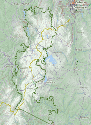
The park is located in the southeastern corner of New South Wales, 354 km (220 mi) southwest of Sydney, and is contiguous with the Alpine National Park in Victoria to the south, and the Namadgi National Park in the Australian Capital Territory to the north east. The larger towns of Cooma, Tumut and Jindabyne lie just outside and service the park.
The waters of the Snowy River, the Murray River, and Gungarlin River all rise in this park. Other notable peaks in the park include Gungartan, Mount Jagungal, Bimberi Peak and Mount Townsend.
On 7 November 2008, the Park was added to the Australian National Heritage List as one of eleven areas constituting the Australian Alps National Parks and Reserves.[2]
History


The Snowy Mountains region is thought to have had Aboriginal occupation for some twenty thousand years, though harsh winter weather made habitation of the snow country impossible. Large-scale intertribal gatherings were held in the High Country during summer for collective feasting on the Bogong moth. This practice continued until around 1864.[3]
The area was first explored by Europeans in 1835, and in 1840, Edmund Strzelecki ascended Mount Kosciuszko and named it after a Polish patriot. High-country stockmen followed, using the Snowy Mountains for grazing during the summer months. Banjo Paterson's famous poem The Man From Snowy River recalls this era. The cattle graziers have left a legacy of mountain huts scattered across the area.[4] Today these huts are maintained by the National Parks and Wildlife Service or volunteer organisations like the Kosciuszko Huts Association.[5] In the 19th century, gold was mined on the high plains near Kiandra.[6] At its height, this community had a population of about 4,000 people, and ran 14 hotels. It was here that Skiing in Australia commenced around 1861. Since the last resident left in 1974, Kiandra has become a ghost town of ruins and abandoned diggings.[7] In the 20th century, the focus of Skiing in New South Wales shifted south closer to the Kosciuszko Main Range.
The Kosciuszko National Park came into existence as the National Chase Snowy Mountains on 5 December 1906. In April 1944, following the passage of the Kosciusko State Park Act, the Kosciuszko State Park was proclaimed.[6][8][9] It then became the Kosciuszko National Park in 1967.[10] The name was misspelt as Kosciusko until 1997.[6]
The construction of the Snowy Mountains Scheme between 1949–74 saw much of the area explored, brought improvements to roads and resulted in the construction of several dams and tunnels across the Park in one of the world's largest engineering achievements
Climate
The higher regions of the park experience an alpine climate which is unusual on mainland Australia. However, only the peaks of the main range are subject to consistent heavy winter snow. The climate station at Charlotte Pass recorded Australia's lowest temperature of −23 °C (−9 °F) on 28 June 1994.[11]
Glaciation
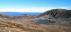
During the last ice age, which peaked about 20,000 years ago in the Pleistocene epoch, the highest peaks of the main range near Mount Kosciuszko experienced a climate which favoured the formation of glaciers, evidence of which can still be seen today. Cirques moraines, tarn lakes, roche moutonnées and other glacial features can all be seen in the area. Lake Cootapatamba, which was formed by an ice spilling from Mount Kosciuszko's southern flank, is the highest lake on the Australian mainland. Lake Albina, Club Lake, Blue Lake, and Hedley Tarn also have glacial origins.[12]
There is some disagreement as to exactly how widespread Pleistocene glaciation was on the main range, and little or no evidence from earlier glacial periods exists. The 'David Moraine', a one-kilometre-long ridge running across Spencers Creek valley seems to indicate a larger glacier existed in this area at some time, however the glacial origin of this feature is disputed.[13]
There is evidence of periglacial activity in the area. Solifluction appears to have created terraces on the northwest flank of Mount Northcote. Frost heave is also a significant agent of soil erosion in the Kosciuszko Area.
Ecology

The Kosciuszko National Park covers a variety of climatic regions which support several distinct ecosystems.
That which is most closely identified with the park, the alpine area above the tree line, is one of the most fragile and covers the smallest area. This area is a patchwork of alpine heaths, herbfields, feldmarks, bogs and fens. The windswept feldmark ecotope is endemic to the alpine region, and covers a mere 300,000 m2 (3,200,000 sq ft). It is most vulnerable to the wandering footsteps of unmindful tourists.
Fauna
Many rare or threatened plant and animal species occur within the boundaries of the park and nine separate wilderness areas have been identified in the latest management scheme.[14] The park is home to one of Australia's most threatened species: the corroboree frog. The endangered mountain pygmy possum and the more common dusky antechinus are located in the high country of the park.
There are also significant populations of feral animals in the park, including wild horses. Park authorities have coordinated their culling and relocation,[15] leading to public controversy over how to reduce their numbers. The actual number of horses within the park is also difficult to ascertain with estimates ranging from 1700 in 2008 increasing by 300 each year,[16] 7679 in 2009,[17] and from 2500 to 14,000 in 2013-2014.[18][19][20]
Flora
Much of the park is dominated by alpine woodlands, characterised by the snow gum. Montane and wet sclerophyll forest also occur across the ranges, supporting large stands of alpine ash and mountain gum. In the southern Byadbo wilderness area, dry sclerophyll and wattle forests predominate. Amongst the many different native trees in the park, the large Chinese elm has become naturalised.
Much of the tree cover in the lower sections of the park was seriously burned in bushfires in 2003. Fires are a natural feature of the park ecosystem, but it will take some time for the region to return to its pre 2003 condition.
Recreational uses

Winter
The mountains are typically covered by metre-deep snow for up to four months of the year.[6] The ski resorts of Thredbo, Selwyn snowfields, Perisher and Charlotte Pass lie within the park. The electric rack railway, called the Skitube Alpine Railway, connects the Alpine Way to the Perisher Valley.
Summer
The 655 kilometre Australian Alps Walking Track crosses almost the length of the park. Many thousands of people make the walk to Mount Kosciuszko during the summer. It is 9 kilometres from Charlotte Pass, or 6 kilometres from the Thredbo chairlift. Camping is permitted anywhere in the park except within sight of a road or near a watercourse. The lighting of fires is severely restricted in higher altitudes.[6]
Mountain biking is allowed on all management trails outside of wilderness areas, and on a small number within them: Grey Mare Trail, Round Mountain Trail, Valentine Trail, Hellhole Creek Trail, Cascade Trail, Ingegoodbee Trail and Nine Mile Trail.[21]
Canoeing and swimming in the rivers and lakes are popular in the warmer weather.[6] The rivers and dams are stocked with trout from nearby hatcheries. Seasonal trout fishing is allowed after a permit is obtained. Other attractions include the whitewater rafting, trail riding, Yarrangobilly Caves, Cooleman Caves, Tin Mine Falls, Australia's highest waterfall and Valentine Falls. Guided tours are conducted through several caves in the karst region of Yarrangobilly. Other tours are also available.
Sawpit Creek has a major campground with facilities for caravans and cabins available for rent.[6]
The Snowy Mountains Hydroelectric Scheme
The Snowy River originates in the park and flows south to Victoria. Many tunnels, dams, generators and other parts of the Snowy Mountains Scheme hydro-electric system are located within the park, including the Tantangara Reservoir.
The Snowy Scheme, constructed between 1949 and 1974, is a hydroelectricity and irrigation complex consisting of sixteen major dams; seven power stations; a pumping station; and 225 kilometres of tunnels, pipelines and aqueducts. The Chief engineer was Sir William Hudson. It is the largest engineering project undertaken in Australia.[22][23][24]
See also
- Australian Alps
- Australian Alps National Parks and Reserves
- Last Glacial Maximum
- National Parks in New South Wales
- Protected areas of New South Wales
- Snowy Mountains
- Tadeusz Kościuszko
- List of biosphere reserves in Australia
References
- ↑ Kosciuszko: Reflections on YouTube
- ↑ "Australian Alps National Parks information". Department of the Environment, Water, Heritage and the Arts. Retrieved 2010-06-10.
- ↑ Kiandra Historical Society
- ↑ http://www.kosciuskohuts.org.au/ Kosciuszko Huts Association
- ↑ Kosciuszko Huts Association
- 1 2 3 4 5 6 7 Hema Maps (1997). Discover Australia's National Parks. Milsons Point, New South Wales: Random House Australia. pp. 112—115. ISBN 1-875992-47-2.
- ↑ "DECC Kosciuszko National Park". DECC National Parks website. Retrieved 2009-04-24.
- ↑ "KOSCIUSKO STATE PARK.". The Sydney Morning Herald. National Library of Australia. 1 November 1944. p. 7. Retrieved 25 April 2014.
- ↑ "Kosciusko State Park Act 1944" (PDF). AustLit. p. 1. Retrieved 25 April 2014.
- ↑ "Top of Australia hosts park's centenary". ABC News Australia. 5 December 2006. Retrieved 25 April 2014.
- ↑ "1301.0 – Year Book Australia, 2008". Australian Bureau of Statistics. 7 February 2008. Retrieved 2008-04-30.
- ↑ West,D.,(1994) Kosciuszko Natural Heritage.
- ↑ Galloway, RW (1963), Glaciation in the Snowy Mountains: A Re-appraisal
- ↑ DECC | Kosciuszko National Park – plan of management
- ↑ "Environmentalists call for aerial brumby cull". ABC News. Retrieved 2008-01-16.
- ↑ "Environmentalists call for aerial brumby cull". ABC News. Retrieved 2015-01-03.
- ↑ Dawson, Michelle. "2009 Aerial Survey of feral Horses in the Australian Alps" (PDF). http://theaustralianalps.wordpress.com/. Retrieved 3 January 2015. External link in
|website=(help) - ↑ Thistleton, John (26 July 2014). "Kosciuszko wild horses should be culled, says activist". The Canberra Times. Retrieved 3 January 2015.
- ↑ Singhal, Pallavi; Elliot, Tim (3 January 2015). "Aerial culling of brumbies in Snowy Mountains: controversial ban to remain". The Canberra Times. Retrieved 3 January 2015.
- ↑ "Wild horses 'damaging alpine ecosystem'". The Canberra Times. AAP. 27 May 2013. Retrieved 3 January 2015.
- ↑ "Trails in Kosciuszko" (PDF).
- ↑ Australian Bureau of Statistics 1986 Special Article: The Snowy Mountains Hydro-Electric Scheme
- ↑ The Snowy Mountains Scheme
- ↑ Wendy Lewis, Simon Balderstone and John Bowan (2006). Events That Shaped Australia. New Holland. pp. 189–194. ISBN 978-1-74110-492-9.
External links
| Wikimedia Commons has media related to Kosciuszko National Park. |
| Townships and Villages | |
|---|---|
| Localities and rural places |
|
| National parks and other natural features | |
| Rivers and other watercourses | |
| Dams and/or associated reservoirs |
|
| Mountain ranges |
|
| Attractions | |
Main Article: Local government areas of New South Wales | |