Sydney Harbour National Park
| Sydney Harbour National Park New South Wales | |
|---|---|
|
IUCN category V (protected landscape/seascape) | |
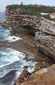 The Gap bluff in the national park at South Head. | |
 Sydney Harbour National Park | |
| Nearest town or city | Sydney |
| Coordinates | 33°47′48″S 151°17′30″E / 33.79667°S 151.29167°ECoordinates: 33°47′48″S 151°17′30″E / 33.79667°S 151.29167°E |
| Established | 4 April 1975[1] |
| Area | 3.92 km2 (1.5 sq mi)[1] |
| Managing authorities | NSW National Parks and Wildlife Service |
| Website | Sydney Harbour National Park |
| See also |
Protected areas of New South Wales |
The Sydney Harbour National Park is a protected national park comprising parts of Sydney Harbour, its foreshores and various islands. The 392-hectare (970-acre) national park lies within the Sydney metropolitan area and was created progressively, from 1975.[1]
The national park protects the landforms of Bradleys Head, Clark Island, Dobroyd Head, Fort Denison, Georges Head, Goat Island, Middle Head, Nielsen Park, Rodd Island, Shark Island, Sydney Heads including the Quarantine Station at North Head and The Gap bluff at South Head. The national park also protects the waterway between North Head and Dobroyd Head, defined as the North Sydney Harbour Aquatic Reserve. Parts of the national park lie outside the harbour and face the Tasman Sea.[2]
The national park is managed by the NSW National Parks and Wildlife Service.
Features
The national park is renowned for its sheltered beaches, tranquil picnic spots, rich Aboriginal, colonial and military heritage, aquatic reserves and harbour islands.[3]
The Guringai Resting Places, at both Reef Beach and Quarantine Station, are Aboriginal reburial sites where ancestral remains have been returned to Country. Access to the Aboriginal burial sites is restricted at the request of the Aboriginal community.[4][5]
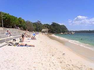
Military fortifications, at the Georges Head Battery, Fort Denison, and North and South Heads stretch back to the early years of the colony. At the Quarantine Station there are archaeological features and over a thousand engravings. Historic sites include Greycliffe House, erected at Shark Bay by the Wentworth family in neo-Gothic style during the 1850s; and the mast of the first HMAS Sydney at Bradleys Head. There is also a swimming beach at Nielsen Park, a restaurant and a cafe.[2]
History
Residential development has impacted a significant amount of the harbour foreshores over many years. Much of what remained was preserved partly due to the presence of military bases, and partly because of the work of conservationists. Early conservationists were responsible for stopping mining at Ashton Park in the 19th Century. Other places were saved because of people such as Neil Nielsen, who became the New South Wales Minister for Lands and a strong advocate of a public reserve around Sydney Harbour.
Nielsen was ahead of his time when he used the phrase "national park" in regard to the harbour foreshores, but Sydney eventually caught up with him. It was not possible to undo all the damage done in past decades, but there was still much that could be preserved, and the 1960s were a particularly active time in this regard. In 1965 the Government of New South Wales began buying land around the foreshores, and the National Trust suggested a national park in 1968. In the following year, the NSW Government announced a plan whereby it would buy Commonwealth land around the harbour. The Sydney Harbour National Park was finally gazetted in 1975, with Nielsen Park at Shark Bay being added in 1978. Extra land was transferred from Commonwealth to State Government control, and added to the national park in 1979; the historically important quarantine station at Manly was added in 1984.
See also
References
- 1 2 3 "Sydney Harbour National Park: Park management". Office of Environment and Heritage. Government of New South Wales. Retrieved 3 October 2014.
- 1 2 "Sydney Harbour National Park: Plan of management" (PDF). NSW National Parks and Wildlife Service (PDF brochure). Government of New South Wales. December 2012. ISBN 978-1-74293-815-8. Retrieved 4 October 2014.
- ↑ "Sydney Harbour National Park". NSW National Parks and Wildlife Service (PDF brochure). Government of New South Wales. Retrieved 4 October 2014.
- ↑ "Atlas of Aboriginal Places: Guringai Resting Place: Reef Beach". Office of Environment and Heritage. Government of New South Wales. 21 May 2013. Retrieved 4 October 2014.
- ↑ "Atlas of Aboriginal Places: Guringai Resting Place: Quarantine Station". Office of Environment and Heritage. Government of New South Wales. 21 May 2013. Retrieved 4 October 2014.
External links
- "Sydney Harbour National Park". NSW National Parks and Wildlife Service. Government of New South Wales.
- "Sydney Harbour National Park". NSW National Parks and Wildlife Service (PDF brochure). Government of New South Wales.
- Picture of Sydney Harbour National Park (north).
- Picture of Sydney Harbour National Park (south).