Höga Kusten Airport
| Höga Kusten Airport Kramfors/Sollefteå Flygplats | |||||||||||
|---|---|---|---|---|---|---|---|---|---|---|---|
|
| |||||||||||
 | |||||||||||
| IATA: KRF – ICAO: ESNK | |||||||||||
| Summary | |||||||||||
| Airport type | Public and other municipalities | ||||||||||
| Owner | Kramfors Municipality and Sollefteå Municipality | ||||||||||
| Operator | Höga Kusten Airport AB | ||||||||||
| Serves | Kramfors, Sollefteå | ||||||||||
| Location | Nyland, Sweden | ||||||||||
| Elevation AMSL | 10 m / 33 ft | ||||||||||
| Coordinates | 63°02′55″N 017°46′08″E / 63.04861°N 17.76889°ECoordinates: 63°02′55″N 017°46′08″E / 63.04861°N 17.76889°E | ||||||||||
| Website | hogakustenairport.com | ||||||||||
| Map | |||||||||||
 KRF Airport in Västernorrland | |||||||||||
| Runways | |||||||||||
| |||||||||||
| Statistics (2012) | |||||||||||
| |||||||||||
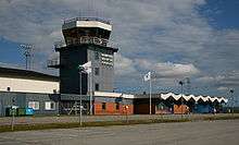
Höga Kusten Airport, translated High Coast Airport, by authorities such as IATA and Transportstyrelsen known as Kramfors-Sollefteå Airport, is an airport located between the towns of Kramfors and Sollefteå, Sweden (IATA: KRF, ICAO: ESNK). The airport is still named Kramfors on tickets and flight lists on other airports.
The number of passengers in 2012 was 18,455, dropping sharply from 62,000 in 2000. The reason for this is low price flights from larger relatively nearby airports like Örnsköldsvik Airport and Sundsvall-Härnösand Airport (travel has not been reduced overall during this period, but the Kramfors passengers have to a large extent chosen other routes). The figures were only 14,787 in 2008 due to the bankruptcy of the airline Nordic Regional.
Airlines and destinations
| Airlines | Destinations |
|---|---|
| NextJet | Lycksele,[1] Stockholm–Arlanda, Vilhelmina |
Transportation
Ground transport is by taxi, shared taxi, rental car or own car.
There is (since August 2012) a railway station on the Ådalen Line 1½ km (1 mile) from the airport. Taxi transfer is available, which should be prebooked.