Lärbro Church
| Lärbro Church | |
|---|---|
| Lärbro kyrka | |
 Lärbro Church, external view | |
 Lärbro Church | |
| 57°47′13″N 18°47′37″E / 57.78694°N 18.79361°E | |
| Country | Sweden |
| Denomination | Church of Sweden |
| Administration | |
| Diocese | Visby |
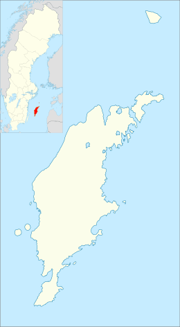
Lärbro Church (Swedish: Lärbro kyrka) is a medieval Lutheran church in Lärbro on the Swedish island of Gotland, in the Diocese of Visby.
History
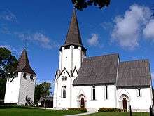
Lärbro Church is built at a formerly strategically important position, and the oldest part of the church ensemble is a defensive tower close to the church. The tower was erected at the end of the 12th century in five storeys, and is still intact. It is today used for temporary exhibitions.[1]
A Romanesque stone church was built at the site at approximately the same time as the tower, but of this first church only a few details, including a portal, have been preserved and incorporated into the presently visible, mainly Gothic church. Reconstruction works, transforming the Romanesque edifice to the one we see today, started during the end of the 13th century. The nave and choir were erected at almost the same time, the choir being only slightly older than the nave. The unusual, octagonal tower was built in the 1340s. The church was from the start richly decorated with both frescos and stone sculptures.[1][2]
The tower was originally twice its present size, but damaged in a storm in 1522 and never rebuilt to its former height. The church has been largely unaltered since.[2]
Architecture
The most unusual feature of the church in Lärbro is the octagonal tower, unique among the country-side churches of Gotland. Inspiration may have come from a now ruined church in Visby, as well as from Visby Cathedral. The tower is richly decorated with gargoyles and reliefs, and has an unusually grand western portal, decorated with sculptures of saints (including St. Olaf) and sculptures depicting the story of the childhood of Christ.[2] Scholars have speculated as to why the church received such an unusual tower. It may have been used as a chapel dedicated to St. Olaf, and inspiration for the unusual form may then have come from Nidaros Cathedral in Norway.[1]
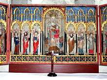
The nave and choir also have richly sculpted external portals. Inside, the church is large and airy. Fragments of originally rich fresco decorations survive, including uncommon combinations of sculpted and painted elements (e.g. in the form of a dragon with a sculpted stone head and a body painted onto the wall). Among the furnishings, a bishop's chair from the 13th century and the peculiar altarpiece, originally from circa 1400 but repainted in 1746, merit special mention. Most other furnishings are locally made, from the 17th and 18th centuries.[2]
Cemetery
Close to the church is a cemetery which belonged to a war-time hospital, active in Lärbro 1939–1946.[3] Although never extensively used by the Swedish army since Sweden did not take part in the fighting in World War II, the hospital admitted refugees with tuberculosis, including refugees from the Soviet occupation of the Baltic States, former concentration camp prisoners from Auschwitz and Bergen-Belsen and even fleeing Wehrmacht soldiers.[3][4] The hospital treated circa 500 patients from concentration camps, many Polish nationals.[3][4] Of these 45 did not survive, and they are buried in the cemetery.[3][4] Polish authorities have erected a memorial plaque in the cemetery in memory of those deceased.[3]
References
- 1 2 3 Andrén, Anders (2011). Det Medeltida Gotland. En arkeologisk guidebok (in Swedish). Lund: Historiska Media. pp. 179–181. ISBN 978-91-85873-83-8.
- 1 2 3 4 Svahnström, Gunnar (1973). Lagerlöf, Erland, ed. Gotlands kyrkor (in Swedish). Uddevalla: Rabén & Sjögren. pp. 208–211. ISBN 9129410355.
- 1 2 3 4 5 "Lärbro krigssjukhus museum" (in Swedish). Lärbro hembygdsmuseum (Lärbro local museum). Retrieved 31 August 2013.
- 1 2 3 Hedström, Katarina. "Mysteriet på Lärbro kyrkogård löst" (in Swedish). Sveriges radio (Radio Sweden). Retrieved 31 August 2013.
External links
| Wikimedia Commons has media related to Lärbro Church. |
- Official website (Swedish)

Coordinates: 57°47′13″N 18°47′37″E / 57.78694°N 18.79361°E