LaGrange, New York
| LaGrange, New York | |
|---|---|
| Town | |
|
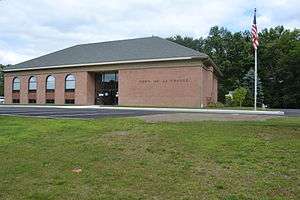
Town Hall | |
 Location of LaGrange, New York | |
| Coordinates: 41°40′23″N 73°48′24″W / 41.67306°N 73.80667°WCoordinates: 41°40′23″N 73°48′24″W / 41.67306°N 73.80667°W | |
| Country | United States |
| State | New York |
| County | Dutchess |
| Government | |
| • Type | Town Council |
| • Town Supervisor | Alan Bell (R) |
| • Town Council |
Members' List
|
| Area | |
| • Total | 40.3 sq mi (104.5 km2) |
| • Land | 39.9 sq mi (103.3 km2) |
| • Water | 0.5 sq mi (1.2 km2) |
| Elevation | 318 ft (97 m) |
| Population (2010) | |
| • Total | 15,730 |
| • Density | 394/sq mi (152.3/km2) |
| Time zone | Eastern (EST) (UTC-5) |
| • Summer (DST) | EDT (UTC-4) |
| ZIP code | 12540,12603, 12569 |
| Area code(s) | 845 |
| FIPS code | 36-40299 |
| GNIS feature ID | 0979126 |
| Website |
lagrangeny |
LaGrange /ləˈɡreɪndʒ/ is a town in Dutchess County, New York, United States. The population was 15,730 at the 2010 census.[1] The town was named after the ancestral estate of the wife of the Marquis de Lafayette.[2]
History
The town was originally established in 1821 as "Freedom" from parts of the towns of Beekman and Fishkill, but confusion with another location caused the name to be changed to "LaGrange" in 1828.
Geography
According to the United States Census Bureau, the town has a total area of 40.3 square miles (104.5 km2), of which 39.9 square miles (103.3 km2) is land and 0.46 square miles (1.2 km2), or 1.17%, is water.[1] The town of LaGrange is located within the Hudson Valley region of New York.
Roads
Three state highways bisect the town and connect it with other towns in Dutchess County and the surrounding area. The Taconic State Parkway is a north-south parkway through LaGrange. James Baird State Park, which provides a golf course, playground, sports fields, and hiking and cycling trails, is located in LaGrange along the Taconic Parkway. The parkway also serves as an important commuter road for LaGrange, connecting the town to points south, including New York City, 75 miles (121 km) distant.
New York State Route 55 is an east-west road that goes through the center of the town; Arlington High School, the Freedom Plains Presbyterian Church, and multiple shops and stores are located on a two-mile section of Route 55 in Freedom Plains, a hamlet of LaGrange. In the summer and fall of 2014, three traffic circles were added to this stretch of Route 55 in Freedom Plains in an effort to ease congestion and also to beautify this part of LaGrange. To the west, Route 55 connects LaGrange to the city of Poughkeepsie, the closest urbanized area to LaGrange; to the east, Route 55 connects LaGrange to the town of Pawling and the Route 22 corridor.
New York State Route 82 is a highway that goes southwest-northeast through the town, from Hopewell Junction to Moores Mills. Route 82 connects LaGrange with Millbrook to the north and Hopewell Junction to the south.
There are also several county roads that go in various parts of the town.
Parks and recreation
Freedom Park is the largest and most extensive park belonging to the town of LaGrange. At the park, there is a small, spring-fed lake in which patrons are permitted to swim under the supervision of Red-Cross-trained lifeguards. There is a set of eight 25-yard lap lanes that enables the town to support a swim team. There is a concession that sells snacks at the lake. Freedom Park also boasts a bandstand and a large, permanent, open-air pavilion; there is a small playground as well. Each summer, a day camp is offered by the town at Freedom Park.
Other parks in LaGrange include Stringham Park, an extensive complex of soccer fields located on Stringham Road in the west of the town, and James Baird State Park, which provides a golf course, playground, and cycling and hiking trails.
Demographics
| Historical population | |||
|---|---|---|---|
| Census | Pop. | %± | |
| 1830 | 2,044 | — | |
| 1840 | 1,851 | −9.4% | |
| 1850 | 1,941 | 4.9% | |
| 1860 | 1,850 | −4.7% | |
| 1870 | 1,774 | −4.1% | |
| 1880 | 1,745 | −1.6% | |
| 1890 | 1,463 | −16.2% | |
| 1900 | 1,304 | −10.9% | |
| 1910 | 1,350 | 3.5% | |
| 1920 | 1,132 | −16.1% | |
| 1930 | 1,210 | 6.9% | |
| 1940 | 1,638 | 35.4% | |
| 1950 | 2,280 | 39.2% | |
| 1960 | 6,079 | 166.6% | |
| 1970 | 10,902 | 79.3% | |
| 1980 | 12,375 | 13.5% | |
| 1990 | 13,274 | 7.3% | |
| 2000 | 14,928 | 12.5% | |
| 2010 | 15,730 | 5.4% | |
| Est. 2014 | 15,750 | [3] | 0.1% |
As of the census[5] of 2000, there were 14,928 people, 5,085 households, and 4,103 families residing in the town. The population density was 376.0 people per square mile (145.2/km²). There were 5,240 housing units at an average density of 132.0 per square mile (51.0/km²). The racial makeup of the town was 91.98% White, 2.41% African American, 0.12% Native American, 2.94% Asian, 1.14% from other races, and 1.41% from two or more races. Hispanic or Latino of any race were 4.26% of the population.
There were 5,085 households out of which 40.6% had children under the age of 18 living with them, 71.2% were married couples living together, 6.5% had a female householder with no husband present, and 19.3% were non-families. 15.4% of all households were made up of individuals and 5.5% had someone living alone who was 65 years of age or older. The average household size was 2.93 and the average family size was 3.28.
In the town the population was spread out with 28.5% under the age of 18, 5.9% from 18 to 24, 29.9% from 25 to 44, 25.3% from 45 to 64, and 10.4% who were 65 years of age or older. The median age was 38 years. For every 100 females there were 97.5 males. For every 100 females age 18 and over, there were 96.0 males.
The median income for a household in the town was $74,881, and the median income for a family was $80,724. Males had a median income of $61,806 versus $36,955 for females. The per capita income for the town was $27,872. About 1.7% of families and 3.7% of the population were below the poverty line, including 4.2% of those under age 18 and 2.4% of those age 65 or over.
Notable people
- Pierre A. Barker, former mayor of Buffalo, New York
- John Gatins, Oscar-nominated screenwriter
- Isaac R. Harrington, former mayor of Buffalo, New York
- Anthony Van Wyck, former member of the Wisconsin State Senate
Communities and locations in LaGrange
- Arthursburg – A hamlet at the south town line.
- Billings – A hamlet north of LaGrangeville.
- Freedom Plains – A hamlet northwest of LaGrangeville.
- James Baird State Park – A state park in the north part of the town.
- LaGrangeville (or La Grangeville) – A hamlet in the southeast part of the town.[6]
- LaGrangeville is an area in LaGrange with the zip code of 12540. As of 2014, this area had a population of 8,221, which makes it the largest part of LaGrange.
- Manchester Bridge – A hamlet in the western part of the town.
- Moores Mill – A location in the northeast part of the town.
- Noxon – A location west of LaGrangeville.
- Rombout Ridge – A location near the west town line.
- Titus – A hamlet near the west town line.
Arlington High School and LaGrange Middle School of the Arlington Central School District are in LaGrange, as are several of the School District's primary, elementary and intermediate schools.
References
- 1 2 "Geographic Identifiers: 2010 Demographic Profile Data (G001): La Grange town, Dutchess County, New York". U.S. Census Bureau, American Factfinder. Retrieved November 12, 2015.
- ↑ Gannett, Henry (1905). The Origin of Certain Place Names in the United States. Government Printing Office. p. 179.
- ↑ "Annual Estimates of the Resident Population for Incorporated Places: April 1, 2010 to July 1, 2014". Retrieved June 4, 2015.
- ↑ "Census of Population and Housing". Census.gov. Retrieved June 4, 2015.
- ↑ "American FactFinder". United States Census Bureau. Retrieved 2008-01-31.
- ↑ "Lagrangeville". Geographic Names Information System. United States Geological Survey.
External links
| Wikimedia Commons has media related to LaGrange, New York. |
- Town of LaGrange official website
- LaGrange Association Library
- Trinity Methodist Church in LaGrange
- Freedom Plains Presbyterian Church in LaGrange
- Arlington Central School District
Municipalities and communities of Dutchess County, New York, United States | ||
|---|---|---|
| Cities |  | |
| Towns | ||
| Villages | ||
| CDPs | ||
| Other hamlets | ||
| Footnotes | ‡This populated place also has portions in an adjacent county or counties | |