La Morandière, Quebec
| La Morandière | |
|---|---|
| Municipality | |
 | |
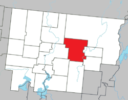 Location within Abitibi RCM. | |
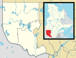 La Morandière Location in western Quebec. | |
| Coordinates: 48°37′N 77°38′W / 48.617°N 77.633°WCoordinates: 48°37′N 77°38′W / 48.617°N 77.633°W[1] | |
| Country |
|
| Province |
|
| Region | Abitibi-Témiscamingue |
| RCM | Abitibi |
| Constituted | January 1, 1983 |
| Government[2][3] | |
| • Mayor | Guy Lemire |
| • Federal riding | Abitibi—Témiscamingue |
| • Prov. riding | Abitibi-Ouest |
| Area[2][4] | |
| • Total | 421.70 km2 (162.82 sq mi) |
| • Land | 410.61 km2 (158.54 sq mi) |
| Population (2011)[4] | |
| • Total | 233 |
| • Density | 0.6/km2 (2/sq mi) |
| • Pop 2006-2011 |
|
| • Dwellings | 111 |
| Time zone | EST (UTC−5) |
| • Summer (DST) | EDT (UTC−4) |
| Postal code(s) | J0Y 1S0 |
| Area code(s) | 819 |
| Highways |
|
| Website |
www |
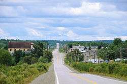
La Morandière is a municipality in the Canadian province of Quebec, located in the Abitibi Regional County Municipality.
In addition to La Morandière itself, the municipality also includes the hamlets of Castagnier (48°44′04″N 77°49′36″W / 48.73444°N 77.82667°W) and Lac-Castagnier (48°42′48″N 77°44′29″W / 48.71333°N 77.74139°W).
Demographics
Population trend:[5]
- Population in 2011: 233 (2006 to 2011 population change: -11.1%)
- Population in 2006: 262
- Population in 2001: 291
- Population in 1996: 295
- Population in 1991: 327
Mother tongue:[6]
- English as first language: 3.8%
- French as first language: 96.2%
- English and French as first language: 0%
- Other as first language: 0%
Municipal council
- Mayor: Guy Lemire
- Councillors: Léopold Carrier, André Desjardins, Solange Gagné, Bernard Meilleur, Lynda Plante, Georgette Rouisse-Coutu
References
- ↑ Reference number 133618 of the Commission de toponymie du Québec (French)
- 1 2 "La Morandière". Répertoire des municipalités (in French). Ministère des Affaires municipales, des Régions et de l'Occupation du territoire. Retrieved 2011-01-12.
- ↑ Parliament of Canada Federal Riding History: ABITIBI--TÉMISCAMINGUE (Quebec)
- 1 2 "La Morandière census profile". 2011 Census data. Statistics Canada. Retrieved 2011-01-12.
- ↑ Statistics Canada: 1996, 2001, 2006, 2011 census
- ↑ "La Morandière community profile". 2006 Census data. Statistics Canada. Retrieved 2011-01-12.
 |
Saint-Dominique-du-Rosaire | Lac-Despinassy | | |
| Amos | |
Rochebaucourt | ||
| ||||
| | ||||
| Landrienne | Barraute | Champneuf |
| Towns | |
|---|---|
| Municipalities | |
| Townships | |
| Parishes | |
| Unorganized territories | |
| |
This article is issued from Wikipedia - version of the 7/29/2016. The text is available under the Creative Commons Attribution/Share Alike but additional terms may apply for the media files.