Lae
| Lae | |
|---|---|
| City | |
|
Welcome signs on approach from Nadzab airport | |
 Lae Location within Papua New Guinea | |
| Coordinates: 6°44′S 147°0′E / 6.733°S 147.000°E | |
| Country |
|
| Province | Morobe Province |
| District | Lae District |
| LLG | Lae Urban LLG |
| Elevation | 8 m (26 ft) |
| Population (2012) | |
| • Total | 100,677 |
| • Rank | 2nd |
| Time zone | PGT (UTC+10) |
| Climate | Af |
Lae(/ˈlæɪ/)[1] is the capital of Morobe Province and is the second-largest city in Papua New Guinea. It is located near the delta of the Markham River and at the start of the Highlands Highway, which is the main land transport corridor between the Highlands region and the coast. Lae is the largest cargo port of the country and is the industrial hub of Papua New Guinea. The city is known as the Garden City and home of the University of Technology.[2]
History

Lucas (1972)[3] describes the history of Lae into four periods; the mission phase (1886–1920), the gold phase (1926 until World War II), the timber and agricultural phase (until 1965) and the industrial boom (from 1965 with the opening of the Highlands Highway[4]
Between 1884 and 1918 the German New Guinea Company established trading posts in Kaiser Wilhelmsland, German New Guinea and on 12 July 1886, a German missionary, Johann Flierl, a pioneer missionary for the Southern Australian Lutheran Synod and the Neuendettelsau Mission Society, sailed to Simbang in Finschhafen, Kaiser-Wilhelmsland and arrived at Lae shortly after.[5]
The mission society provided clergy and religious education for Lutheran settlements in Missouri, Iowa and Ohio, Australia, and anywhere else "free thinking" Lutherans had settled.[6]
After World War I, Eastern New Guinea came under British control (Australia) and many of the Germanic names were replaced by English or Indigenous ones. Adolf Haven was then referred to as Morobe Harbor.[7]
Australian Officials or Kiap's were stationed at various locations within the area [8] and in 1921 the military administration transitioned to a civilian administration, a gold prospector named Cecil John Levien was appointed District Officer (Kiap) of Morobe.


On 1 January 1923 Levien acquired a mining right for the area and shortly after formed a syndicate called Guinea Gold (No Liability).[9] The Guinea Gold syndicate formed Guinea Airways Limited in November 1927.[10] In 1927 Levien arranged for the construction of the airstrip at Lae to assist the gold mine productions around Wau.[11]
Lae was declared a town under the New Guinea Boundaries Ordinance on 31 March 1931 at the height of the gold rush era [12] and Lae became the prototype for New Guinean towns built up around airstrips.[4] The Europeans lived to the East of Lae Airfield while the New Guineans lived to the West.[4] Cargo arrived in Lae and then was transported by air to the goldfields in Wau.
In July 1937, Lae made world news when American aviator Amelia Earhart was last seen flying out of the airport on her way back to the United States. She was never seen again.
When the volcanic eruptions occurred in Rabaul in 1937, a decision was made to transfer the capital of the Territory of New Guinea to Lae. World War II impeded the transfer and the town was occupied by the Empire of Japan on 8 March 1942. Lae, Rabaul and Salamaua became the major Japanese bases in New Guinea.
The naval Battle of the Bismarck Sea in March 1943[13] was fought over the Japanese attempt to reinforce Lae with troops sent by sea from Rabaul, an attempt foiled by sustained Allied attack on the Japanese troop transports. In mid-1943, after defeats in the Kokoda Track campaign, the Battle of Buna–Gona and the Battle of Wau, the Japanese retreated to Lae and Salamaua. However, the Salamaua–Lae campaign involved many weeks of fierce fighting, before the town fell to the Allies on 16 September.
In 1971 the Australian Colonial Administration established the first properly constituted Local Government of Lae town and in 1972 Lae was proclaimed a city.[2] Lae's development after the war is directly linked to the development of the highlands. Coffee and tea were being grown and a port was needed. Later priority was given on road access, and the Highlands Highway came into existence. The mineral boom occurred in the 1980s and 1990s.
Geology
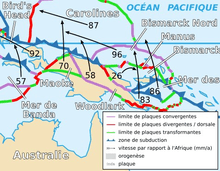
Lae is located on the Pacific Ring of Fire and geologic instability has produced numerous faults, resulting in earthquakes.[14][15]
Lae sits between the larger Indo-Australian Plate and the Pacific Plate on the South Bismarck Plate in the Ramu-Markham Fault Zone where the New Guinea Highlands Deforming Zone and South Bismarck tectonic plates are converging at up to 50 mm/yr. The city is caught in a giant geological vice and the seismic hazard is significant.[16]
More than 15 years of measurements have been analysed with results indicating how rapidly Lae city and its survey network is deforming.[16]
The Ramu-Markham Fault Zone, which follows the northern edge of the Markham Valley, is the active plate boundary between the South Bismarck Plate and tectonostratigraphic terranes within the New Guinea Highlands Deforming Zone. The Ramu-Markham Fault Zone has generated large thrust earthquakes (e.g. 6 April 1999 MW 6.4, 16 km North of Lae, near Hobu, and 22 November 2007 MW 6.8, 110 km North of Lae). Geological evidence suggests that major earthquakes in pre-historic times have occurred in the Lae area,[17] and that there is the potential for another large earthquake to occur anytime within the next 100 years [17][18] (in).[16]
The 1998 earthquake occurred near Vanimo resulting in 2200 casualties.[19]
Mount Lunaman
Mount Lunaman is 96 metres (315 ft) high and has a radio tower at the highest point marked by red fixed obstruction lights to assist navigation.[20] At the base of Mount Lunaman at the southern and south-eastern face are the suburbs of Voco Point and Chinatown. The terraces are located to the West of Mount Lunaman.
Mount Lunaman is known to the locals as Lo' Wamung, which means "first hill",[21] Hospital Hill[22] and Fortress Hill by the German settlers.[23]
Mount Lunaman and the Lae urban area have been the subject of several tectonic studies relating to plate shift.[24]
Mount Lunaman was an important landmark for both Japanese and the Allies:
- "The men of the South Australian battalion hammered and sawed vigorously at the top of the terrace. They were reconstructing, with captured Japanese tools, the skeleton of the cottage formerly used as the Japanese commander's sanctum. A hole beneath the door led by an underground tunnel to a labyrinth of passages and apertures which honeycombed Mount Lunaman".[25]
After the war it was believed that Mount Lunaman contained the remains of many Japanese soldiers who defended Lae using tunnels:
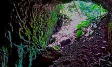
- A Japanese tomb believed to contain bodies of hundreds of Lae defenders was bought by two South Australian men for 1 pound. The tomb lies under Mount Lunaman which is said to house a hospital and when the Japanese in tunnels refused to surrender to the Australian 7th Division and 9th Division troops in 1943 all entrances were sealed.[26]
Government
The Lae City Council is also known as Lae Urban Local-Level Government. It is an Urban Municipal Authority, responsible for the policy decisions, management and administration of the City, by way of providing the municipal services to the residents of the City.[2]
- Lae City Aims to become one of the Garden Cities of Asia Pacific Region by 2012, by creating a modern, safe, vibrant City, with a strong economy, whilst enhancing its cultural heritage, and by developing a Healthy, well Educated, Harmonious Community, which will enjoys a good living environment.[2]
The Lae Urban Local-Level Government is a third-tier Government. The political structure consists of the Lord Mayor as the head, who is elected by the people, with five elected, and three nominated Councilors. The six elected Councilors representing the six Wards in the City. The nominated Councilors represented the Chamber of Commerce, the Workers Federation Union, and the Women, Youth and Churches. The Council makes decisions on the policy issues relating to the City, and the Council Management implement the decisions.[2]
Roads
The Lae City has 137 kilometers of roads, which the National Government is responsible for the maintenance of the Independence Drive, the Markham Road, and the Milford Haven Road, while the Lae City Council maintains the rest of the roads in the City. Due to lack of funding, almost all the roads have deteriorated over the years.[2]
Climate
| Climate data for Lae | |||||||||||||
|---|---|---|---|---|---|---|---|---|---|---|---|---|---|
| Month | Jan | Feb | Mar | Apr | May | Jun | Jul | Aug | Sep | Oct | Nov | Dec | Year |
| Average high °C (°F) | 31.5 (88.7) |
31.5 (88.7) |
31.0 (87.8) |
30.5 (86.9) |
29.8 (85.6) |
28.8 (83.8) |
28.1 (82.6) |
28.0 (82.4) |
28.7 (83.7) |
29.6 (85.3) |
30.5 (86.9) |
31.1 (88) |
29.9 (85.8) |
| Average low °C (°F) | 24.3 (75.7) |
24.2 (75.6) |
24.2 (75.6) |
23.9 (75) |
23.6 (74.5) |
23.0 (73.4) |
22.4 (72.3) |
22.3 (72.1) |
22.6 (72.7) |
23.2 (73.8) |
23.7 (74.7) |
23.9 (75) |
23.4 (74.1) |
| Average rainfall mm (inches) | 241.6 (9.512) |
239.9 (9.445) |
281.1 (11.067) |
347.4 (13.677) |
348.9 (13.736) |
502.8 (19.795) |
477.9 (18.815) |
516.9 (20.35) |
360.9 (14.209) |
442.4 (17.417) |
334.9 (13.185) |
338.2 (13.315) |
4,432.9 (174.524) |
| Average rainy days | 16 | 17 | 18 | 21 | 21 | 21 | 24 | 24 | 22 | 22 | 21 | 19 | 246 |
| Source: World Meteorological Organisation[27] | |||||||||||||
Economy
Industry
Lae is strategically located in that it can supply the highlands, islands, Southern and Momase regions. Large businesses include;
- Paradise Foods Limited
- Halla Cement
- HBS PNG Limited
- iPi Group
- Trukai Rice
- SP Brewery
- Bismark Maritime
- South Pacific Steel
- Papindo Group Of Companies
- Prima Smallgoods
- Lae Biscuit Factory
- Citylink Motel
- MMK Transport
- Barlow Industries Ltd
- Mapai Transport
- PNG Metal Fabricators Ltd _PPS
- Araweld Ltd_PPS
Markets
Lae City boasts of having the best food market in Papua New Guinea. This is due to the fact that the Morobe Province produces the best taros, bananas, sweet potatoes, yams, fruits and vegetables etc., which have been sought after by many Papua New Guineans as well as expatriates. The Lae Main Market also receives and sells foodstuff and vegetables from the Highlands Provinces. Apart from Lae Main Market, wards and mini-markets are also available to cater for the needs of the growing population of the city.[2]
Notable landmarks

University of Technology
The Papua New Guinea University of Technology is based 8 kilometres (5.0 mi) outside of Lae and is the second largest university in PNG after its 'sister' university the University of Papua New Guinea in Port Moresby. While University of Papua New Guinea concentrates on the arts, pure sciences, law and medicine, the University of Technology focuses on research in technological or applied sciences. It is the only technological university in the South Pacific, outside of Australia and New Zealand.[28]
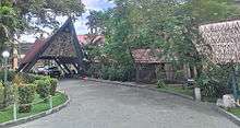
Lae International Hotel
Lae International Hotel is an important conference centre and has hosted some notable political figures over the years.[29] Lae International Hotel (6°43′50″S 147°0′21″E / 6.73056°S 147.00583°E) has 100 rooms, furnished with wooden furnitures and 4 luxury suites. It contains the Vanda Restaurant, Luluai's Italian Restaurant and Kokomo Coffee Shop.[30]
Lae War Cemetery
Lae War Cemetery was established in 1944, and is located adjacent to the Botanical Gardens in the center of the city. The cemetery holds the remains of over 2,800 soldiers, many of whom died in the Salamaua–Lae campaign, but also those who died in Japanese detention on the Island. It is also the resting place of two Victoria Cross recipients.
Lae Botanic Gardens
Lae Botanic gardens are beautifully maintained but not always open to the public. There is an old Australian Aeroplane (circa World War II) in the center of the gardens.
Bumbu river
The Bumbu river starts at the Adzera Mountain range, through Taraka to Kamkumung, Butibam, Bumbu and to the Huon Gulf. Following a flood in 1992, the population was relocated to a temporary settlement called Tent Siti (City).[2]
Angau General Hospital
Angau General Hospital is located in the central Lae area next to the old Lae Airfield. It is a main referral hospital for the general Morobe Province area, as well as the other provinces connected by road link . It contains the only Radiotherapy facility in the country and thus serves as the main referral center for cancer patients.
Lae (Nadzab) Airport
Nadzab Airport is located 56 kilometres (35 mi) outside of Lae City, along the Highlands Highway, next to the Markham River. There are local buses that will take you to Lae, and also escorted secured transfers can transfer you from Nadzab Airport to your accommodation in Lae City.
From Port Moresby, Lae is accessible only by domestic flights. Air Niugini, Airlines of Papua New Guinea (also known as "Airlines PNG") and Travel Air "Mangi lo Ples" services the Port Moresby-Lae route.
Other significant locations

- Sir Ignatius Kilage Stadium
- Lae Golf Course,
- Lae Technical College,
- Lae City Hotel,
- Hotel Morobe,
- Lae Yacht Club,
- Lae Showgrounds
Health care
Visitors must ensure that they have proper health insurance. Lae International Hospital is of good developing world standard. It is a 19-bed facility with 1 emergency bed. It has 6 doctors, one General Practitioner, an Anesthesiologist, a Surgeon, a Radiologist and two Obstetricians. All doctors are from the Philippines and all nurses are local nationals.
The other private hospital is Tusa Private Hospital (corner of Huon Rd and 13th St). There is also a public hospital called Angau Memorial Hospital located on Markham Road.
For travelers to Lae, they should seek expert medical advice regarding malaria prophylaxis as well as Hepatitis A, Hepatitis B, Japanese Encephalitis and Typhoid vaccinations. Of note there was a significant outbreak of Cholera based in the Morobe District in 2009 and consideration of vaccination would be prudent.[31]
Twin town
 Cairns, Australia (Queensland) since 1984
See also
References
- ↑ "lae.". Random House, Inc. Retrieved 26 February 2014.
- 1 2 3 4 5 6 7 8 "Lae City Council". morobepng.com.
- ↑ Lucas, John (June 1972). "Lae – A Town in Transition". Oceania. 4. 42: 260–275. JSTOR 40330020.
- 1 2 3 Suzanne Romaine (1992). Language, Education, and Development: Urban and Rural Tok Pisin in Papua New Guinea. Oxford University Press. pp. 114–. ISBN 978-0-19-823966-6. Retrieved 16 February 2014.
- ↑ "History - Evangelical Lutheran Church of Papua New Guinea". elcpng.org.pg.
- ↑ Garrett, p. 3–4; Löhe, Johann Konrad Wilhelm (New Schaff-Herzog Encyclopedia of Religious Knowledge, Vol. VII)
- ↑ Wurm, S. Mühlhäusler, P, Tyron, D & de Gruyter, W 1996, Intercultural communication in Atlas of Languages of Intercultural Communication in the Pacific, Asia, and the Americas, Volume 1 to GoogleBooks
- ↑ "Website Changes Fall 2014 - The Library". ucsd.edu.
- ↑ Kernot, C, 1999, Valuing Mining Companies: A Guide to the Assessment and Evaluation of Assets, Performance, and Prospects in Business and Economics CRC Press
- ↑ Australian Dictionary of Biography, Volume 10, (MUP), 1986 Levien, Cecil John (1874–1932)
- ↑ Lipscomb, A, McKinnon, R & Murray, J 1998 Lonely Planet
- ↑ Mason, L, & Hereniko, P, 1987 In Search of a Home , University of the South Pacific. Institute of Pacific Studies, 982010016X, 9789820100169
- ↑ "Battle of the Bismarck Sea, 2-4 March 1943". awm.gov.au.
- ↑ USGS. "Seismic Hazard Map". Retrieved 28 February 2014.
- ↑ Earthquake Track. "Recent Earthquake Near New Guinea, Papua New Guinea". Retrieved 28 February 2014.
- 1 2 3 43rd Association of Surveyors PNG Congress, Lae; Richard Stanaway; Laura Wallace; Zebedee Sombo; Johnson Peter; Trevor Palusi; Ben Safomea; John Nathan (12–15 August 2009). "Lae, a City caught between two plates – 15 years of Deformation Measurements with GPS" (PDF). Focus On Challenges; Society-Space-Surveyors. Retrieved 28 February 2014.
- 1 2 Crook, Keith A.W. (June 1989). "Quaternary uplift rates at a plate boundary, Lae urban area, Papua New Guinea" (PDF). Tectonophysics. 163 (1–2): 105–118. doi:10.1016/0040-1951(89)90121-2. Retrieved 28 February 2014.
- ↑ Ripper, I.D.; Anton, L. (1987). "Seismic hazard, Lae". Papua New Guinea Geological Survey Report. 95/2.
- ↑ "Tidal wave kills 'thousands'". BBC News. 1998-07-20. Retrieved 2 April 2007.
- ↑ Prostar Sailing Directions 2004 New Guinea Enroute. ProStar Publications. 1 January 2004. p. 164. ISBN 978-1-57785-569-9.
- ↑ "Mt Lunaman". Lonely Planet. Retrieved 9 February 2014.
- ↑ John Laffin (1956). Return to Glory. Angus and Robertson. p. 77.
- ↑ Fodor's Australia, New Zealand, and the South Pacific. D. McKay. 1989. p. 574. Retrieved 21 February 2014.
- ↑ Crook, Keith A.W (10 June 1989). "Quaternary uplift rates at a plate boundary, Lae urban area, Papua New Guinea". Tectonophysics. 163 (1,2): Pages 105–118. doi:10.1016/0040-1951(89)90121-2. Retrieved 9 February 2014.
- ↑ Semmler, edited by Clement (1987). The war dispatches of Kenneth Slessor, official Australian correspondent, 1940–1944 (1. publ. ed.). St. Lucia, Qld., Australia: University of Queensland Press. p. 382. ISBN 0702220760.
- ↑ "Odd Deal at Lae Sales". The Advertiser (Adelaide, SA : 1931 – 1954). Adelaide, SA: National Library of Australia. 26 November 1946. p. 7. Retrieved 9 February 2014.
- ↑ "World Weather Information Service — Lae City". World Meteorological Organisation. Retrieved 15 December 2015.
- ↑ University of Technology website\Papua_New_Guinea_University_of_Technology
- ↑ Australian foreign affairs and trade, Volume 63, Dept. of Foreign Affairs and Trade, Australia. (1992)
- ↑ Tony Wheeler, Jon Murray (1993). Papua New Guinea: a travel survival kit (5 ed.). Lonely Planet. p. 82. ISBN 0-86442-190-7.
- ↑ Clonal Origins of Vibrio cholerae O1 El Tor Strains, Papua New Guinea, 2009–2011
External links
| Wikimedia Commons has media related to Lae. |
Provincial capitals of Papua New Guinea | ||
|---|---|---|