Lake City, Michigan
| Lake City, Michigan | |
|---|---|
| City | |
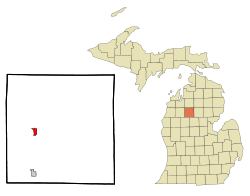 Location of Lake City, Michigan | |
| Coordinates: 44°19′57″N 85°12′47″W / 44.33250°N 85.21306°W | |
| Country | United States |
| State | Michigan |
| County | Missaukee |
| Area[1] | |
| • Total | 1.05 sq mi (2.72 km2) |
| • Land | 1.05 sq mi (2.72 km2) |
| • Water | 0 sq mi (0 km2) |
| Elevation | 1,250 ft (381 m) |
| Population (2010)[2] | |
| • Total | 836 |
| • Estimate (2012[3]) | 849 |
| • Density | 796.2/sq mi (307.4/km2) |
| Time zone | Eastern (EST) (UTC-5) |
| • Summer (DST) | EDT (UTC-4) |
| ZIP code | 49651 |
| Area code(s) | 231 |
| FIPS code | 26-44480[4] |
| GNIS feature ID | 0629968[5] |
Lake City is a city in the U.S. state of Michigan. As of the 2010 census, the city population was 836. Known as the "Christmas Tree Capital", it is the county seat of Missaukee County.[6]
Geography
According to the United States Census Bureau, the city has a total area of 1.05 square miles (2.72 km2), all land.[1] Lake City derives its name from the three inland lakes in or at the edge of the town, which are Lake Missaukee, Lake Sapphire and Crooked Lake. Each is less than a mile from the other.
Transportation
Demographics
| Historical population | |||
|---|---|---|---|
| Census | Pop. | %± | |
| 1880 | 61 | — | |
| 1890 | 663 | 986.9% | |
| 1900 | 816 | 23.1% | |
| 1910 | 740 | −9.3% | |
| 1920 | 582 | −21.4% | |
| 1930 | 610 | 4.8% | |
| 1940 | 693 | 13.6% | |
| 1950 | 719 | 3.8% | |
| 1960 | 718 | −0.1% | |
| 1970 | 704 | −1.9% | |
| 1980 | 843 | 19.7% | |
| 1990 | 858 | 1.8% | |
| 2000 | 923 | 7.6% | |
| 2010 | 836 | −9.4% | |
| Est. 2015 | 843 | [7] | 0.8% |
2010 census
As of the census[2] of 2010, there were 836 people, 337 households, and 216 families residing in the city. The population density was 796.2 inhabitants per square mile (307.4/km2). There were 489 housing units at an average density of 465.7 per square mile (179.8/km2). The racial makeup of the city was 95.2% White, 1.2% African American, 1.7% Native American, 0.7% Asian, and 1.2% from two or more races. Hispanic or Latino of any race were 2.9% of the population.
There were 337 households of which 28.8% had children under the age of 18 living with them, 45.4% were married couples living together, 12.2% had a female householder with no husband present, 6.5% had a male householder with no wife present, and 35.9% were non-families. 32.0% of all households were made up of individuals and 17% had someone living alone who was 65 years of age or older. The average household size was 2.35 and the average family size was 2.89.
The median age in the city was 40.5 years. 23.4% of residents were under the age of 18; 8.6% were between the ages of 18 and 24; 21.2% were from 25 to 44; 27.5% were from 45 to 64; and 19.3% were 65 years of age or older. The gender makeup of the city was 51.2% male and 48.8% female.
2000 census
As of the census[4] of 2000, there were 923 people, 381 households, and 238 families residing in the city. The population density was 854.9 per square mile (330.0/km²). There were 493 housing units at an average density of 456.6 per square mile (176.2/km²). The racial makeup of the city was 97.72% White, 0.11% African American, 0.43% Native American, 0.76% Asian, 0.43% from other races, and 0.54% from two or more races. Hispanic or Latino of any race were 1.63% of the population.

There were 381 households out of which 29.1% had children under the age of 18 living with them, 46.7% were married couples living together, 12.9% had a female householder with no husband present, and 37.3% were non-families. 33.1% of all households were made up of individuals and 15.7% had someone living alone who was 65 years of age or older. The average household size was 2.32 and the average family size was 2.93.
In the city the population was spread out with 24.1% under the age of 18, 9.6% from 18 to 24, 22.5% from 25 to 44, 23.6% from 45 to 64, and 20.2% who were 65 years of age or older. The median age was 41 years. For every 100 females there were 89.9 males. For every 100 females age 18 and over, there were 86.4 males.
The median income for a household in the city was $28,864, and the median income for a family was $34,286. Males had a median income of $27,361 versus $19,044 for females. The per capita income for the city was $17,067. About 10.7% of families and 13.1% of the population were below the poverty line, including 13.7% of those under age 18 and 17.2% of those age 65 or over.
References
- 1 2 "US Gazetteer files 2010". United States Census Bureau. Retrieved 2012-11-25.
- 1 2 "American FactFinder". United States Census Bureau. Retrieved 2012-11-25.
- ↑ "Population Estimates". United States Census Bureau. Retrieved 2013-06-03.
- 1 2 "American FactFinder". United States Census Bureau. Retrieved 2008-01-31.
- ↑ "US Board on Geographic Names". United States Geological Survey. 2007-10-25. Retrieved 2008-01-31.
- ↑ "Find a County". National Association of Counties. Retrieved 2011-06-07.
- ↑ "Annual Estimates of the Resident Population for Incorporated Places: April 1, 2010 to July 1, 2015". Retrieved July 2, 2016.
- ↑ "Census of Population and Housing". Census.gov. Retrieved June 4, 2015.
Municipalities and communities of Missaukee County, Michigan, United States | ||
|---|---|---|
| Cities | 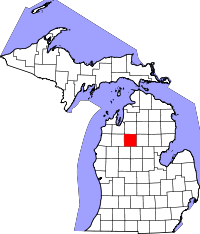 | |
| Townships | ||
| CDP | ||
Coordinates: 44°20′07″N 85°12′54″W / 44.33528°N 85.21500°W