Lake Stevens, Washington
| Lake Stevens, Washington | |
|---|---|
| City | |
|
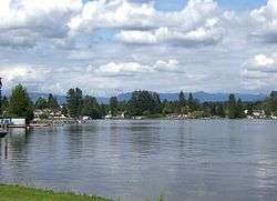
Northeast shore of lake on which the city is located | |
| Motto: "One community, around the lake" | |
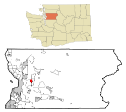 Location of Lake Stevens, Washington | |
| Coordinates: 48°1′11″N 122°3′58″W / 48.01972°N 122.06611°WCoordinates: 48°1′11″N 122°3′58″W / 48.01972°N 122.06611°W | |
| Country | United States |
| State | Washington |
| County | Snohomish |
| Area[1] | |
| • Total | 8.90 sq mi (23.05 km2) |
| • Land | 8.88 sq mi (23.00 km2) |
| • Water | 0.02 sq mi (0.05 km2) |
| Elevation | 217 ft (66 m) |
| Population (2010)[2] | |
| • Total | 28,069 |
| • Estimate (2015)[3] | 30,886 |
| • Density | 3,160.9/sq mi (1,220.4/km2) |
| Time zone | Pacific (PST) (UTC-8) |
| • Summer (DST) | PDT (UTC-7) |
| ZIP code | 98258 |
| Area code | 425 |
| FIPS code | 53-37900 |
| GNIS feature ID | 1512695[4] |
| Website | www.lakestevenswa.gov |
Lake Stevens is a city in Snohomish County, Washington, United States named after the lake that it is built around. It is southeast of Marysville, north of the city of Snohomish, and east of Everett. The population as of the 2010 census was 28,069, with much of the growth due to annexation.
History
Believed to be named after Governor Isaac I. Stevens, the shores of Lake Stevens were first settled in 1886, on a 160-acre (0.65 km2) homestead along the east shore. By 1890 the first town in the area, "Ferry", was established. Its name was later changed to "Hartford", and it served as the main link from the famed Monte Cristo timber and mining resources to the world.
In 1905 a railroad spur was built by the Rucker Brothers Timber Company, linking Hartford with Lake Stevens. Two years later Rucker Mill was opened, located along and in the north cove of the lake (original pilings can still be seen in the old lake outflow area just south of the boat launch). In 1919, the mill, which became known as the "world's largest sawmill", burned and was partially rebuilt. When it burned a second time in 1925 the mill was dismantled and Lake Stevens lost the very industry which caused its founding. However, by then a flourishing town was established and continued under its own momentum.
From the 1920s to the 1950s Lake Stevens was primarily a resort community, with many public and private resort beaches scattered around the shore. On November 29, 1960, Lake Stevens incorporated as a City with a population of 900. Soon, its popularity and natural beauty, combined with changing commuter habits, attracted more and more residents, changing its character to that of a suburban community. By 2000 the City had grown to a population of 6,361 in approximately 1.8 square miles (4.7 km2). The lake remains the focal point of the greater Lake Stevens community for recreation and as "a symbol of our need to provide for a sustainable existence that will protect our natural environment".
Geography
Lake Stevens is located at 48°1′11″N 122°3′58″W / 48.01972°N 122.06611°W (48.019782, -122.066089).[5]
According to the United States Census Bureau, the city has a total area of 8.90 square miles (23.05 km2), of which, 8.88 square miles (23.00 km2) is land and 0.02 square miles (0.05 km2) is water.[1]
The lake itself is the largest and deepest lake in Snohomish County, with an area of 1,040 acres (4.2 km2) and an average depth of 64 feet (20 m).[6] It is fed by Lundeen, Mitchell, Kokanee, and Stitch Creeks and drained by Catherine Creek, which ultimately flows to the Pilchuck River. The small size of the surrounding watershed compared to the lake minimizes the effects of upstream pollution. This combined with an artificial aeration system allows for a generally good water quality.[6] Much of the shoreline is heavily developed, so few wetlands exist adjacent to the lake. Recreational activities include boating, fishing, and swimming.
Demographics
| Historical population | |||
|---|---|---|---|
| Census | Pop. | %± | |
| 1950 | 2,586 | — | |
| 1960 | 1,538 | −40.5% | |
| 1970 | 1,283 | −16.6% | |
| 1980 | 1,660 | 29.4% | |
| 1990 | 3,380 | 103.6% | |
| 2000 | 6,361 | 88.2% | |
| 2010 | 28,069 | 341.3% | |
| Est. 2015 | 30,886 | [7] | 10.0% |
| U.S. Decennial Census[8] 2015 Estimate[3] | |||
2010 census
As of the census[2] of 2010, there were 28,069 people, 9,810 households, and 7,250 families residing in the city. The population density was 3,160.9 inhabitants per square mile (1,220.4/km2). There were 10,414 housing units at an average density of 1,172.7 per square mile (452.8/km2). The racial makeup of the city was 85.1% White, 1.7% African American, 0.9% Native American, 3.6% Asian, 0.4% Pacific Islander, 3.2% from other races, and 5.1% from two or more races. Hispanic or Latino of any race were 8.6% of the population.
There were 9,810 households of which 45.1% had children under the age of 18 living with them, 56.3% were married couples living together, 11.9% had a female householder with no husband present, 5.8% had a male householder with no wife present, and 26.1% were non-families. 19.1% of all households were made up of individuals and 5.2% had someone living alone who was 65 years of age or older. The average household size was 2.86 and the average family size was 3.26.
The median age in the city was 32.5 years. 29.9% of residents were under the age of 18; 8.5% were between the ages of 18 and 24; 32.2% were from 25 to 44; 23% were from 45 to 64; and 6.5% were 65 years of age or older. The gender makeup of the city was 49.9% male and 50.1% female.
2000 census
As of the census of 2000, there were 6,361 people, 2,139 households, and 1,683 families residing in the city. The population density was 2,951.8 people per square mile (1,142.3/km²). There were 2,234 housing units at an average density of 1,036.7 per square mile (401.2/km²). The racial makeup of the city was 92.31% White, 0.60% African American, 0.91% Native American, 1.10% Asian, 0.31% Pacific Islander, 0.90% from other races, and 3.87% from two or more races. Hispanic or Latino of any race were 3.55% of the population.
There were 2,139 households out of which 49.9% had children under the age of 18 living with them, 65.5% were married couples living together, 9.3% had a female householder with no husband present, and 21.3% were non-families. 15.7% of all households were made up of individuals and 5.0% had someone living alone who was 65 years of age or older. The average household size was 2.96 and the average family size was 3.30.
In the city the age distribution of the population shows 33.9% under the age of 18, 6.5% from 18 to 24, 36.3% from 25 to 44, 17.6% from 45 to 64, and 5.7% who were 65 years of age or older. The median age was 32 years. For every 100 females there were 101.6 males. For every 100 females age 18 and over, there were 97.0 males.
The median income for a household in the city was $65,231, and the median income for a family was $68,250. Males had a median income of $51,536 versus $30,239 for females. The per capita income for the city was $22,943. About 3.8% of families and 4.4% of the population were below the poverty line, including 3.9% of those under age 18 and 9.0% of those age 65 or over.
City government
Mayor and council
Lake Stevens government operates under the mayor-council system. The mayor serves as the executive of the city, while the council serves as the legislative body of the city.
Voters elect a mayor and seven councilmembers to serve, each to four-year terms. All positions are non-partisan. Elections for the mayoral and council positions are held in staggered cycles, meaning that not all positions are up for election in the same year. The cycles are as follows:
- Mayor; council positions three, four, and five - last held in 2011; next cycle is 2015
- Council positions one, two, six, and seven - last held in 2013
In instances of vacation of a seat, the city council has the authority to fill the seat, including that of the mayor. This most recently occurred in November 2009, when position one became vacant in the final two months of that term, and was subsequently filled by the current office holder (who won that seat in the November 2009 election for the current term). Elections for appointed positions may be held for the unexpired portion of the term outside that position's normal election cycle. This occurred in the 2007 election cycle for position six.
The table shown below details the make up of the council since 1996:
| Served | Mayor | Position 1 | Position 2 | Position 3 | Position 4 | Position 5 | Position 6 | Position 7 |
|---|---|---|---|---|---|---|---|---|
| 1996 | Jay Echols | Neal DooleyA - 1991 | Larry Wagner | Genevieve Moore | Lynn Walty | Glenn McLoughlin | ||
| 1997 | ||||||||
| 1998 | Jack Blackwell | Richard Maddalena | ||||||
| 1999 | ||||||||
| 2000 | Lynn WaltyD | Rich EstepB | Dan ReichenbergD | |||||
| 2001 | ||||||||
| 2002 | Larry WagnerD | |||||||
| 2003 | ||||||||
| 2004 | Steve BrooksD | Karen AlessiB | Vern LittleB | |||||
| 2005 | ||||||||
| 2006 | Walty / LittleA-Nov. | Heather ColemanB | Arnie ClarkE | Tom HartwellB | ||||
| 2007 | Vern LittleF | Suzanne QuigleyA-Jan, F | Clark / HolderA-Feb, F | |||||
| 2008 | John SpencerC, E | Mark SomersB | Kathy Holder | |||||
| 2009 | Coleman / DaughtryA-Nov. | |||||||
| 2010 | Kim DaughtryD | Marcus TageantD | ||||||
| 2011 | ||||||||
| 2012 | Todd WelchD | |||||||
| 2013 | ||||||||
| 2014 | ||||||||
| 2015 |
- Table key:
|
|
- Color-coded year corresponds to election held in that year for said position. See section above regarding elections for unexpired terms (position six, for 2007 election cycle).
- Source: Snohomish County Elections
Non-elected positions
Prominent (non-elected) positions for the city include: city administrator, city clerk, police chief, planning director, public works director, and community programs planner.
Boards and commissions
The city has several boards and commissions whose role is to advise the council on a variety of issues specific to that board or commission. Members of each board or commission are volunteers from the community, either as residents or property owners from within the urban growth area. They are appointed by the mayor with council approval. The exception is with the civil service commission, which all members, who must reside inside the city limits, are appointed by the mayor exclusively. These boards and commissions include:
- Arts commission
- Civil service commission
- Design review board (made up of members of the planning commission)
- Library board
- Parks board
- Planning commission
- Zoning board (made up of city council members)
More information
Annexation and the unincorporated "Urban Growth Area"
Since 2005, the population of the City of Lake Stevens has nearly quadrupled from 7,400 to 28,069 currently. This has been primarily due to an effort called "One Community Around the Lake" to bring the unincorporated areas within the Urban Growth Area into the city limits. The table shown below details these efforts:
| Area Annexed | Method | Month & Year | Ordinance | Acres / Square Miles | Population | New City Population | % Increase |
|---|---|---|---|---|---|---|---|
| Northlake | Direct Petition | January 2006 | 719 | 855 / 1.34 | 2,300 | 9,700 | 31.1% |
| Frontier Village | Direct Petition | December 2006 | 729 | 708 / 1.11 | 3,600 | 13,300 | 37.1% |
| Soper Hill | Direct Petition | May 2007 | 742 | 292 / 0.46 | 1,200 | 14,500 | 9.0% |
| Southwest | Election (56.38% FOR) | December 2009 | 801 | 2,374 / 3.71 | 10,874 | 25,674 | 73.5% |
Additionally, two small annexations have taken place during this time. The Fire District Annexation, the 1.02-acre (4,100 m2) Station 82 property on the southwest corner of Chapel Hill Road and 99th Ave NE, occurred in October 2007 (Ordinance 745), and the Corniche Annexation, the 2.91-acre (11,800 m2) commercially zoned vacant parcel on the southwest corner of Market Place and 91st Ave NE, occurred in March 2008 (Ordinance 768). Neither added to the city's population.
School district
Lake Stevens consists of one high school (Lake Stevens High School and one mid-high school (Cavelero, grades 8-9), two middle schools (Lake Stevens and North Lake) and six elementary schools (Mt. Pilchuck, Sunnycrest, Hillcrest, Glenwood, Skyline, and Highland) with a seventh elementary and a new early learning center opening during the 17-18 school year.
Community newspaper
The Lake Stevens Journal is the community newspaper and is circulated weekly.
Parks, trails, and ballfields
Highlighted by the lake itself, Greater Lake Stevens is home to numerous parks, trails, and ballfields, including:
- Bond Field
- Bonneville Field
- Catherine Creek Park
- Cavalero Park (off-leash dog park)
- Centennial Trail
- City Beach
- City Boat Launch
- Eagle Ridge Park
- Hartford Field
- Kid's Oasis Playground
- Lake Stevens Community Park
- Lochsloy Fields
- Lundeen Park
- North Cove Park
- Sunset Park
- Wyatt Park (Davies Beach)
Notable people
- Chris Pratt, actor[9]
- Cory Kennedy, professional skateboarder[10]
- Jacob Eason, University of Georgia football quarterback
- Katie Snyder, actor in the show Little Women: NY, currently lives here
- Paramedic Dudder, Paramedic Jones, Lake Stevens Fire, A Shift
References
- 1 2 "US Gazetteer files 2010". United States Census Bureau. Retrieved 2012-12-19.
- 1 2 "American FactFinder". United States Census Bureau. Retrieved 2012-12-19.
- 1 2 "Population Estimates". United States Census Bureau. Retrieved June 18, 2016.
- ↑ "US Board on Geographic Names". United States Geological Survey. 2007-10-25. Retrieved 2008-01-31.
- ↑ "US Gazetteer files: 2010, 2000, and 1990". United States Census Bureau. 2011-02-12. Retrieved 2011-04-23.
- 1 2 "Integrated Aquatic Plant Control Plan" (PDF). City of Lake Stevens. January 2011. Retrieved 13 June 2011.
- ↑ "Annual Estimates of the Resident Population for Incorporated Places: April 1, 2010 to July 1, 2015". Retrieved July 2, 2016.
- ↑ "U.S. Decennial Census". Census.gov. Retrieved June 6, 2013.
- ↑ Sandy Ringer (14 February 2011). "Lake Stevens wrestlers try to pin down storybook ending for documentary". The Seattle Times. Retrieved 30 March 2014.
- ↑ crailtap (4 May 2010). "Mini Top 5 with Cory Kennedy concerning his big move to California.". crailtap on YouTube. Google Inc. Retrieved 30 March 2014.
External links
| Wikimedia Commons has media related to Lake Stevens, Washington. |
Municipalities and communities of Snohomish County, Washington, United States | ||
|---|---|---|
| Cities |  | |
| Towns | ||
| CDPs |
| |
| Other unincorporated communities | ||
| Ghost town | ||
| Indian reservation | ||
| Footnotes | ‡This populated place also has portions in an adjacent county or counties | |