Eichstätt (district)
| Kreis Eichstätt | |
|---|---|
| District | |
 | |
| Country |
|
| State | Bavaria |
| Adm. region | Oberbayern |
| Capital | Eichstätt |
| Area | |
| • Total | 1,214 km2 (469 sq mi) |
| Population (31 December 2015)[1] | |
| • Total | 128,805 |
| • Density | 110/km2 (270/sq mi) |
| Time zone | CET (UTC+1) |
| • Summer (DST) | CEST (UTC+2) |
| Vehicle registration | EI |
| Website | landkreis-eichstaett.de |
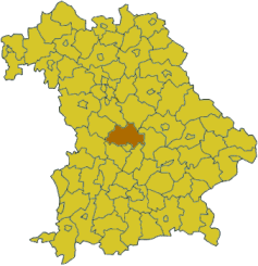
Eichstätt is a district in Bavaria, Germany. It is bounded by (from the south and clockwise) the districts of Neuburg-Schrobenhausen, Donau-Ries, Weißenburg-Gunzenhausen, Roth, Neumarkt, Kelheim and Pfaffenhofen, and by the city of Ingolstadt.
History
The district of Eichstätt in its present form was established in 1972 by merging the former district of Eichstätt with parts of the dissolved districts of Ingolstadt, Beilngries, Riedenburg and Hilpoltstein. The city of Eichstätt lost its status as a district-free city and became the capital of the new district. Today the Eichstätt district has powerful economic structures. The rate of jobless people is only 1.2% (June 2011).
Geography
The district is located in the southern part of the Frankish Alb. 80% of the district are situated in the Altmühltal Nature Park. In the southeast the Danube forms a short part of the border.
Coat of arms
 |
The coat of arms displays:
|
Towns and municipalities
| Towns | Municipalities | |
|---|---|---|
References
- ↑ "Fortschreibung des Bevölkerungsstandes". Bayerisches Landesamt für Statistik und Datenverarbeitung (in German). June 2016.
External links
| Wikimedia Commons has media related to Landkreis Eichstätt. |
- Official website (German)
- Altmühltal Nature Park (German, English)
Coordinates: 48°55′N 11°20′E / 48.92°N 11.33°E