Würzburg (district)
| Würzburg | |
|---|---|
| District | |
 | |
| Country |
|
| State | Bavaria |
| Adm. region | Unterfranken |
| Capital | Würzburg |
| Area | |
| • Total | 968.4 km2 (373.9 sq mi) |
| Population (31 December 2015)[1] | |
| • Total | 160,427 |
| • Density | 170/km2 (430/sq mi) |
| Time zone | CET (UTC+1) |
| • Summer (DST) | CEST (UTC+2) |
| Vehicle registration | WÜ, OCH |
| Website | landkreis-wuerzburg.de |
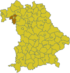
Würzburg is a Kreis (district) in the northwestern part of Bavaria, Germany. Neighboring districts are (from the north, clockwise) Main-Spessart, Schweinfurt, Kitzingen, Neustadt (Aisch)-Bad Windsheim, and the district Main-Tauber in Baden-Württemberg. The city Würzburg is not part of the district, although it is completely enclosed by it.
History
In 1852, districts were created in the region, including the two precursor districts of Würzburg and Ochsenfurt. In 1972 the previous district Würzburg was merged with the former district Ochsenfurt, and several municipalities from the districts Marktheidenfeld, Karlstadt, Kitzingen and Gerolzhofen were added to form the district with today's borders.
Partnerships
The district has sister city-like partnerships with these regions:
-
 - Matte Yehuda Regional Council, Israel
 -
 - Olomouc Region, Czech Republic
Coat of arms
The district coat of arms might be described thus: Per fess in chief gules dancetty of three argent, in base per pale argent two lions passant guardant sable armed and langued of the first and azure a fleur-de-lis Or.
 |
In chief (the upper part of the coat of arms) is the "Franconian Rake", the symbol of the former Electoral State of Würzburg. In base, on the dexter (armsbearer’s right, viewer’s left) side, the fleur-de-lis is the symbol of the St. Burkhard monastery in Würzburg, while the lions on the sinister (armsbearer’s left, viewer’s right) side derive from the coat of arms of the former Ochsenfurt district. |
Towns and municipalities
| Towns | Verwaltungsgemeinschaften | Municipalities | |
|---|---|---|---|
|
|||
| ¹ administrated inside a Verwaltungsgemeinschaft | |||
References
- ↑ "Fortschreibung des Bevölkerungsstandes". Bayerisches Landesamt für Statistik und Datenverarbeitung (in German). June 2016.
External links
| Wikimedia Commons has media related to Landkreis Würzburg. |
Coordinates: 49°40′N 10°00′E / 49.66°N 10.0°E