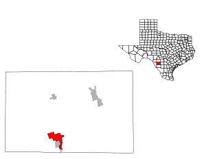
Las Colonias, Texas
| Las Colonias, Texas | |
|---|---|
| CDP | |
 | |
| Coordinates: 28°42′44″N 99°49′10″W / 28.71222°N 99.81944°WCoordinates: 28°42′44″N 99°49′10″W / 28.71222°N 99.81944°W | |
| Country | United States |
| State | Texas |
| County | Zavala |
| Area | |
| • Total | 13.6 sq mi (35.2 km2) |
| • Land | 13.5 sq mi (35.1 km2) |
| • Water | 0.0 sq mi (0.1 km2) |
| Elevation | 600 ft (183 m) |
| Population (2000) | |
| • Total | 283 |
| • Density | 20.9/sq mi (8.1/km2) |
| Time zone | Central (CST) (UTC-6) |
| • Summer (DST) | CDT (UTC-5) |
| FIPS code | 48-41563[1] |
| GNIS feature ID | 1852725[2] |
Las Colonias is a census-designated place (CDP) in Zavala County, Texas, United States. The population was 283 at the 2000 census.
Geography
Las Colonias is located at 28°42′44″N 99°49′10″W / 28.71222°N 99.81944°W (28.712295, -99.819576).[3]
According to the United States Census Bureau, the CDP has a total area of 13.6 square miles (35.2 km²), of which, 13.6 square miles (35.1 km²) of it is land and 0.04 square miles (0.1 km²) of it (0.29%) is water.
Demographics
As of the census[1] of 2000, there were 283 people, 76 households, and 68 families residing in the CDP. The population density was 20.9 people per square mile (8.1/km²). There were 95 housing units at an average density of 7.0/sq mi (2.7/km²). The racial makeup of the CDP was 78.09% White, 20.14% from other races, and 1.77% from two or more races. Hispanic or Latino of any race were 91.52% of the population.
There were 76 households out of which 51.3% had children under the age of 18 living with them, 80.3% were married couples living together, 7.9% had a female householder with no husband present, and 10.5% were non-families. 9.2% of all households were made up of individuals and 2.6% had someone living alone who was 65 years of age or older. The average household size was 3.72 and the average family size was 4.00.
In the CDP the population was spread out with 36.7% under the age of 18, 8.5% from 18 to 24, 27.6% from 25 to 44, 14.5% from 45 to 64, and 12.7% who were 65 years of age or older. The median age was 28 years. For every 100 females there were 106.6 males. For every 100 females age 18 and over, there were 98.9 males.
The median income for a household in the CDP was $9,583, and the median income for a family was $15,568. Males had a median income of $11,146 versus $0 for females. The per capita income for the CDP was $11,754. About 65.5% of families and 66.2% of the population were below the poverty line, including 85.7% of those under the age of eighteen and 52.9% of those sixty five or over.
Education
Las Colonias is served by the Crystal City Independent School District.
References
- 1 2 "American FactFinder". United States Census Bureau. Retrieved 2008-01-31.
- ↑ "US Board on Geographic Names". United States Geological Survey. 2007-10-25. Retrieved 2008-01-31.
- ↑ "US Gazetteer files: 2010, 2000, and 1990". United States Census Bureau. 2011-02-12. Retrieved 2011-04-23.
Municipalities and communities of Zavala County, Texas, United States | ||
|---|---|---|
| City | 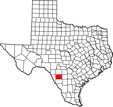 | |
| CDPs |
| |