Lastours
| Lastours | ||
|---|---|---|
 | ||
| ||
 Lastours | ||
|
Location within Occitanie region  Lastours | ||
| Coordinates: 43°20′06″N 2°22′47″E / 43.335°N 2.3797°ECoordinates: 43°20′06″N 2°22′47″E / 43.335°N 2.3797°E | ||
| Country | France | |
| Region | Occitanie | |
| Department | Aude | |
| Arrondissement | Carcassonne | |
| Canton | Mas-Cabardès | |
| Intercommunality | Haut Cabardès | |
| Government | ||
| • Mayor (2008–2014) | Max Brail | |
| Area1 | 2.80 km2 (1.08 sq mi) | |
| Population (2008)2 | 165 | |
| • Density | 59/km2 (150/sq mi) | |
| Time zone | CET (UTC+1) | |
| • Summer (DST) | CEST (UTC+2) | |
| INSEE/Postal code | 11194 / 11600 | |
| Elevation |
163–383 m (535–1,257 ft) (avg. 180 m or 590 ft) | |
|
1 French Land Register data, which excludes lakes, ponds, glaciers > 1 km² (0.386 sq mi or 247 acres) and river estuaries. 2 Population without double counting: residents of multiple communes (e.g., students and military personnel) only counted once. | ||
.svg.png)
Lastours (Occitan: Las Tors) is a commune in the Aude department in southern France.
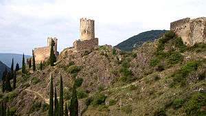
Lastours is located 12 km (7.5 mi) outside Carcassonne, in the valley of the Orbiel. There are four small castles each built on a large 300 m high rocky ridge. The castles were built to control the access to Montagne Noire and the Cabardes region. These are some of the few original Cathar castles left.
Population
| Historical population | ||
|---|---|---|
| Year | Pop. | ±% |
| 1962 | 439 | — |
| 1968 | 444 | +1.1% |
| 1975 | 300 | −32.4% |
| 1982 | 248 | −17.3% |
| 1990 | 159 | −35.9% |
| 1999 | 163 | +2.5% |
| 2008 | 165 | +1.2% |
See also
References
| Wikimedia Commons has media related to Lastours. |
This article is issued from Wikipedia - version of the 2/22/2013. The text is available under the Creative Commons Attribution/Share Alike but additional terms may apply for the media files.