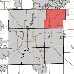
Lawrence Township, Marion County, Indiana
| Lawrence Township Marion County | |
|---|---|
| Township | |
 | |
| Coordinates: 39°52′48″N 86°00′37″W / 39.88000°N 86.01028°WCoordinates: 39°52′48″N 86°00′37″W / 39.88000°N 86.01028°W | |
| Country | United States |
| State | Indiana |
| County | Marion |
| Government | |
| • Type | Indiana township |
| Area | |
| • Total | 48.51 sq mi (125.64 km2) |
| • Land | 46.92 sq mi (121.53 km2) |
| • Water | 1.59 sq mi (4.11 km2) |
| Elevation[1] | 751 ft (229 m) |
| Population (2010) | |
| • Total | 118,447 |
| • Density | 2,400/sq mi (940/km2) |
| FIPS code | 18-42444[2] |
| GNIS feature ID | 453545 |
Lawrence Township is one of nine townships in Marion County, Indiana, United States. The population was 118,447 at the 2010 census.[3] Lawrence Township was organized in 1822.[4][5]
The Metropolitan School District of Lawrence Township provides services to students in portions of Lawrence Township and the City of Lawrence.
Oaklandon
The Oaklandon Historic District is located in the northeast corner of Lawrence Township in northeastern Marion County, and encompasses a portion of the mid-19th century settlement known as Oaklandon. Located approximately 14 miles northeast of downtown Indianapolis, the Oaklandon area is currently a part of the city of Lawrence, which after a six-year court battle annexed it, Indian Lake and other unincorporated parts of Lawrence Township in 1976.[6]
When Oaklandon was established in 1849 along the route of the Indianapolis and Bellefontaine Railroad, it was surrounded by farms and vacant land; now it is enveloped by the urban sprawl of Indianapolis and Lawrence. Late 20th century housing developments, many of them planned using winding streets or cul de sacs, can be seen to the south, west, and north of the community.
Just north of the district is the railroad right-of-way established in the late 1840s, and currently used by CSX Transportation. To the south is Pendleton Pike, once a toll road which passed directly through Oaklandon, running north along present day Oaklandon Road, and then west along what is now Broadway Street. Pendleton Pike was rerouted in the early 20th century so that it passed along the southern edge of the community, and is now a busy six lane thoroughfare lined with strip malls and other commercial activities. The district’s building stock is composed of small and medium-sized residences and outbuildings dating from the late 19th and early 20th centuries, along with two church buildings from the same era.[7]
Oaklandon never incorporated, and therefore had no official town limits, but appears never to have developed south of present-day Pendleton Pike. Until its demolition in the early 1940s, the community’s two story brick school stood at the northwest corner of Oaklandon Road and Pendleton Pike and would have alerted travelers of the small town just to the north. Today a modern retail development occupies the school’s site, but that development’s sign includes a panel bearing the words “Oaklandon Community established 1849.” Upon passing that sign and heading into the historic district, one immediately notices that the area differs from the surrounding commercial and residential area. The feeling of a small town is engendered by the relative narrowness of the streets and the older housing stock. That atmosphere is further reinforced by the small lots and modest setbacks that characterize the housing stock on Oaklandon Road, the older part of the district. This section of Oaklandon Road (from Pendleton Pike north to Broadway) is also the only street in the area with streetlights, curbs and sidewalks. The latter were initially installed for the benefit of the community’s children, who once walked along Oaklandon Road to the aforementioned school.[7]
References
- ↑ "US Board on Geographic Names". United States Geological Survey. 2007-10-25. Retrieved 2008-01-31.
- ↑ "American FactFinder". United States Census Bureau. Retrieved 2008-01-31.
- ↑ "Profile of General Population and Housing Characteristics: 2010 Demographic Profile Data (DP-1): Lawrence township, Marion County, Indiana". U.S. Census Bureau, American Factfinder. Retrieved February 13, 2012.
- ↑ Bodenhamer, David J.; Barrows, Robert G. (22 November 1994). The Encyclopedia of Indianapolis. Indiana University Press. p. 900. ISBN 0-253-11249-4.
- ↑ Sulgrove, Berry Robinson (1884). History of Indianapolis and Marion County, Indiana. L.H. Everts & Company. p. 536.
- ↑ http://www.polis.iupui.edu/RUC/neighborhoods/LawrenceGeist/LawrenceTimeline.htm
- 1 2 http://www.in.gov/dnr/historic/files/hp-oaklandon.pdf