Le Havre – Octeville Airport
| Le Havre - Octeville Airport Aéroport du Havre - Octeville Advanced Landing Ground (ALG) Y-30 | |||||||||||
|---|---|---|---|---|---|---|---|---|---|---|---|
| IATA: LEH – ICAO: LFOH | |||||||||||
| Summary | |||||||||||
| Airport type | Public | ||||||||||
| Operator | SNC-Lavalin Aéroports | ||||||||||
| Serves | Le Havre | ||||||||||
| Location | Octeville-sur-Mer, Seine-Maritime, France | ||||||||||
| Elevation AMSL | 312 ft / 95 m | ||||||||||
| Coordinates | 49°32′02″N 000°05′17″E / 49.53389°N 0.08806°E | ||||||||||
| Website | www.lehavre.aeroport.fr | ||||||||||
| Maps | |||||||||||
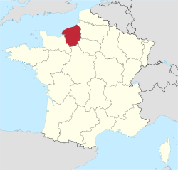
 Location of Haute-Normandie region in France | |||||||||||
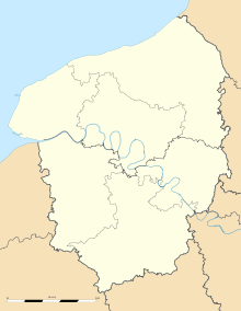
 LFOH Location of airport in Haute-Normandie region | |||||||||||
| Runways | |||||||||||
| |||||||||||
Le Havre – Octeville Airport (French: Aéroport du Havre - Octeville[2]) (IATA: LEH, ICAO: LFOH) is an airport serving the city of Le Havre in France.[1] The airport is located in Octeville-sur-Mer, 5 km (3 NM) north-northwest of Le Havre,[1] both communes in the Seine-Maritime department in the Haute-Normandie region in northern France.
Facilities
The airport resides at an elevation of 312 feet (95 m) above mean sea level. It has one paved runway designated 05/23 which measures 2,300 by 40 metres (7,546 ft × 131 ft).[1]
Airlines and destinations
After Twin Jet left, there are currently no scheduled services to or from Le Havre.
References
- 1 2 3 4 LFOH – Le Havre Octeville. AIP from French Service d'information aéronautique, effective 10 November 2016.
- 1 2 (French) Aéroport du Havre - Octeville (LEH / LFOH) at Union des Aéroports Français
- ↑ Airport information for LFOH from DAFIF (effective October 2006)
- ↑ Airport information for LEH at Great Circle Mapper. Source: DAFIF (effective October 2006).
External links
- (French) Aéroport du Havre-Octeville, official site
- Current weather for LFOH at NOAA/NWS
- Accident history for LEH at Aviation Safety Network
This article is issued from Wikipedia - version of the 2/8/2015. The text is available under the Creative Commons Attribution/Share Alike but additional terms may apply for the media files.