Leatherwood Creek (Wills Creek)
| Leatherwood Creek | |
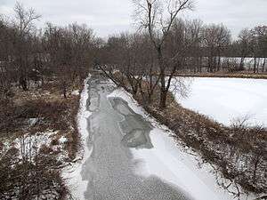 Leatherwood Creek in Cambridge in December 2010 | |
| Country | United States |
|---|---|
| State | Ohio |
| Counties | Belmont, Noble, Guernsey |
| Cities | Quaker City, Salesville, Lore City, Cambridge |
| Source | |
| - location | near Barnesville in Warren Township, Belmont County |
| - elevation | 1,139 ft (347 m) [1] |
| - coordinates | 39°59′25″N 81°11′21″W / 39.9903483°N 81.1892745°W [2] |
| Mouth | Wills Creek |
| - location | Cambridge |
| - elevation | 778 ft (237 m) [2] |
| - coordinates | 40°00′36″N 81°34′36″W / 40.0100720°N 81.5767893°WCoordinates: 40°00′36″N 81°34′36″W / 40.0100720°N 81.5767893°W [2] |
| Length | 28.6 mi (46 km) |
| Basin | 91.6 sq mi (237 km2) |
| Discharge | for near Kipling |
| - average | 82.9 cu ft/s (2 m3/s) [3] |
| - max | 10,100 cu ft/s (286 m3/s) |
| - min | 0 cu ft/s (0 m3/s) |
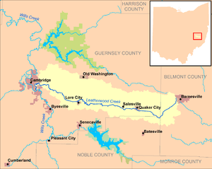 Leatherwood Creek and its watershed | |
Leatherwood Creek is a tributary of Wills Creek, 28.6 miles (46.0 km) long,[4] in eastern Ohio in the United States. Via Wills Creek and the Muskingum and Ohio rivers, it is part of the watershed of the Mississippi River, draining an area of 91.6 square miles (237 km2)[4] on the unglaciated portion of the Allegheny Plateau.
Leatherwood Creek rises just outside the western boundary[5] of the village of Barnesville in Warren Township in Belmont County and flows generally westward, first through a small portion of northeastern Beaver Township in Noble County, and into Guernsey County where it flows through Millwood, Richland, Wills, Center, and Cambridge townships, and through the villages of Quaker City, Salesville, and Lore City. It flows into Wills Creek in the southern part of the city of Cambridge.[6]
Leatherwood Creek was named for the leatherwood which grew along its course.[7]
Flow rate
At the United States Geological Survey's stream gauge near the community of Kipling, the annual mean flow of the creek between 2000 and 2011 was 82.9 ft³/s (2 m³/s). The highest recorded flow during the period was 10,100 ft³/s (286 m³/s) on September 18, 2004. A reading of no flow was recorded on September 2, 2003.[3]
See also
- List of rivers of Ohio
- Joseph C. Dylkes, the "Leatherwood God"
References
- ↑ The National Map elevation query for GNIS source coordinates. Retrieved on 2013-05-14.
- 1 2 3 Geographic Names Information System. "Geographic Names Information System entry for Leatherwood Creek (Feature ID #1066352)". Retrieved 2013-05-14.
- 1 2 "Water resources data for the United States, Water Year 2011: U.S. Geological Survey Water Data Report 2011, 03141870 Leatherwood Creek near Kipling, OH" (PDF). United States Geological Survey. 2012. Retrieved 2013-05-15.
- 1 2 Ohio Department of Natural Resources (August 2001). "Gazetteer of Ohio Streams" (PDF). p. 77. Archived from the original on 2013-03-21. Retrieved 2013-05-14.
- ↑ The National Map query for GNIS source coordinates. Retrieved on 2013-05-14.
- ↑ Ohio Atlas & Gazetteer. Yarmouth, Me.: DeLorme. 1991. pp. 61, 71–72. ISBN 0-89933-233-1.
- ↑ Sarchet, Cyrus Parkinson Beatty (1911). History of Guernsey County, Ohio, Volume 1. B.F. Bowen & Company. p. 29.